
 United Kingdom
 France
 Germany
 Netherlands
 Sweden
 USA
USA
 Italy
Italy
 Spain
Spain
More From Contributor


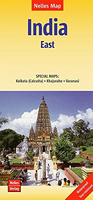
India East Nelles
Eastern India at 1:1, 500, 000 in a series of double-sided maps from Nelles, with their slightly smaller size offering a convenient format for use when travelling. The map includes an enlargement showing in greater detail the environs of Kolkata/Calcutta as well as street plans of central Kolkata and Varanasi, plus a site map of Khajuraho group of temples.Maps in the Nelles regional series of India present the country’s road and rail networks on a base with relief shading to show the topography. National parks and nature or game reserves are highlighted, as are numerous places of interest. Also shown are the country’s internal administrative boundaries with names of the states. Each map includes enlargements for most visited areas and/or street plans of main cities. Latitude and
longitude are shown by margin ticks at 2°. None of the maps are indexed. Map legend includes English.To see other titles in this series please click on the series link.
longitude are shown by margin ticks at 2°. None of the maps are indexed. Map legend includes English.To see other titles in this series please click on the series link.

Product Description
Reviews/Comments
Add New
Vouchers
No voucher codes found.
Do you know a voucher code for this product or supplier? Add it to Insights for others to use.
Do you know a voucher code for this product or supplier? Add it to Insights for others to use.
 Denmark