
 United Kingdom
 France
 Germany
 Netherlands
 Sweden
 USA
USA
 Italy
Italy
 Spain
Spain
More From Contributor


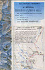


K2 & Baltoro Glacier
Stunning satellite image of the Karakoram, centred on K2 and the Baltoro Glacier, produced by the Polish Mountaineering Association and annotated with names of peaks and glaciers, numerous spot heights, passes, trekking and approach routes, base camps and seasonal settlements. The image, derived from data gathered by Spot 4 and Landsat 7 in 2001, was published in 2004 to celebrate the 100th anniversary of the Association and the 50th anniversary of the first ascent of K2.-The map has margin ticks showing latitude and longitude at intervals of 10
Product Description
Reviews/Comments
Add New
Intelligent Comparison
Archived Product

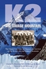
K2 And Baltoro Glacier Stanfords
£16.50
Archived Product

K2 And Baltoro Glacier Wall Map Stanfords
£19.99
Archived Product

Batura Glacier Stanfords
£20.00
Vouchers
No voucher codes found.
Do you know a voucher code for this product or supplier? Add it to Insights for others to use.
Do you know a voucher code for this product or supplier? Add it to Insights for others to use.
 Denmark