
 United Kingdom
 France
 Germany
 Netherlands
 Sweden
 USA
USA
 Italy
Italy
 Spain
Spain
More From Contributor


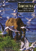
Kamchatka
A double-side map presenting the Kamchatska oblast in two halves: the northern portion (from Ust-Kamchatsk to the northern border) is at the smaller scale of 1:1, 200, 000, the rest is at 1:800, 000. The Commander Islands are displayed in an inset.Road detail distinguishes paved and unpaved roads, and shows intermediate driving distances. Topographic details portrayed include swamps, waterfalls, glaciers, gullies, lava fields & volcanoes. General relief is shown by elevation tinting and spot heights for selected peaks. District boundaries are marked, also nature reserves and national parks. A range of symbols denote various features eg. hotels, post offices, campgrounds, archeological sites, natural curiosities, hospitals & helicopter excursion centes. Various recreational and
wildlife observing localities are also indicated eg. fishing, rafting, seal colonies, diving sites. Latitude and longitude lines are drawn at 1
wildlife observing localities are also indicated eg. fishing, rafting, seal colonies, diving sites. Latitude and longitude lines are drawn at 1
Product Description
Reviews/Comments
Add New
Intelligent Comparison
Archived Product

Kamchatka Stanfords
£8.99
Vouchers
No voucher codes found.
Do you know a voucher code for this product or supplier? Add it to Insights for others to use.
Do you know a voucher code for this product or supplier? Add it to Insights for others to use.
 Denmark