More From Contributor

£6.95
Wallpaper* City Guides present a tightly edited, discreetly packaged list of the best a location has to offer the design conscious traveller. Here is a precise, informative, insider`s checklist of all you need to know about the world`s most intoxicating cities. Whether you are staying for 48 hours or five days, visiting for business or a vacation, we`ve done the hard work for you, from finding the best restaurants, bars & hotels (including which rooms to request) to the most extraordinary stores & sites, & the most enticing architecture & design. Wallpaper* City Guides enable you to come away from your trip, however brief, with a real taste of the city`s landscape & the satisfaction you`ve seen all that you should. In short, these guides act as a passport to the best the world has to offer. ...
Archived Product
£10.99
Kyoto, Osaka & Kobe in the Michelin Red Guides series; hotel & restaurant guides that have an unparalleled reputation for reliability & consistency, making extensive use of keyed information to provide detailed & concise reviews. Guides are predominantly intended for the markets they are reviewing &, as such, are more often than not written in the native language (s) of their featured destination, that said, most foreign language guides do come with a range of English language introductory & explanatory information such as thorough details on how to use the guide & a description of its symbol classifications. The obvious exceptions to this structure are locations which already have English as their official language. Guides feature hundreds of hotels and/or restaurants & rate them according to the time honoured Michelin standards. Reviews are arranged alphabetically by location & introduce places & establishments, providing you with details of other relevant Michelin publications, situating the businesses & detailing facilities & services, as well as the all important price range. Establishment descriptions look at the atmosphere, d ...
Archived Product
£16.99
Deep within central Asia, Kyrgyzstan`s beautiful mountainscapes, dreamlike rock formations & semi-nomadic culture are gloriously unspoiled. A trip here can be as adventurous as you please: admire 5, 000-year-old petroglyphs at Saimaluu-Tash, gallop on horseback through the rugged Ala-Archa Canyon, visit Bishkek`s Soviet-era statues or simply laze on the shores of the vast Lake Issyk-Kul. Now in its third edition, this remains the only English-language guide dedicated solely to Kyrgyzstan. It offers in-depth coverage of historical background, health, safety & transport, plus author recommendations on the best yurt camps & chaikhanas. You can join Laurence Mitchell on a magnificent journey through the country`s remote Silk Road villages, ancient conifer forests & rolling alpine meadows. ...
Archived Product
£15.99
Following the break-up of the USSR, Kyrgyzstan soon earned a reputation as the most hospitable & least repressive of the newly emerged central Asian republics. Unlike some of its neighbours, it has actively encouraged foreign tourism & has pursued a policy of supporting community projects with an emphasis on adventure tourism. The Bradt guide details all the services & experiences the country offers including trekking, mountaineering, horseriding & wildlife-watching. Historical sites, cultural activities & background on the Kyrgystan people are all covered by this definitive guide. ...
Archived Product
£9.99
Kyrgyzstan at 1:750, 000 from Gizi Map with excellent presentation of the country’s mountainous terrain through bold altitude colouring & plenty of names of mountain ranges, etc, road network indicating routes of the old Silk Road, plus a street plan of Bishkek & an administrative map of the country. All place names are in the Latin alphabet. Topography is vividly shown by bold elevation colouring, with spot heights & graphics for swamps, salt flats & deserts, plus plenty of names of mountain ranges, peaks, valleys, etc. National parks are highlighted. The map shows internal provincial boundaries & also clearly indicates the country’s Uzbek & Tadjik enclaves. Road network

Includes::
selected local tracks & highlights routes which used to the part of the old Silk Road. Railway lines are included & local airports are marked. Symbols indicate various places of interest, locations with tourist accommodation including yurt camps, etc. Latitude & longitude lines are drawn at 30’ intervals. The map has on the reverse two separate but cross-referenced indexes, in Latin & Cyrillic script. Map legend

Includes::
English. Two panels provide a street plan of central Bishkek annotated with important buildings, selected hotels & places of interest, plus a small administrative map of the country. This title is also available as a wall map.


...
Archived Product
£14.95
Kyrgyzstan in the Odyssey Guides series; aimed at travellers particularly interested in the culture & history of their destination; the guides focus on the atmosphere, customs, & distinctive character of a country, region or city. As the only English language publisher based in China, Odyssey Guides specialize in Asian destinations, relying on the expertise of local writers. This gives readers more of an insider’s perspective, in companion with the practicalities of navigating through remote Asian landscapes. Each title is heavily dedicated to the culture of the destination, all with accompanying colour photography. The guides also showcase a range of literary excerpts which are taken from travel writers together with translations from the work of indigenous writers & poets, creating a distinctive tone unique to the publisher. There are also basic overview location maps & concise practical advice for visitors, including information on getting there & around, itineraries, climate, health, clothing & equipment, money, photography, communications, security, shopping, media, food & drink, holidays & behavior, customs & etiquette. ...
Archived Product
£13.50
Kyrgyzstan Wall Map at 1:750, 000 from Gizi Map, size 124 x 70cm (49” x 27.5” approx), with excellent presentation of the country’s mountainous terrain through bold altitude colouring & plenty of names of mountain ranges, etc, road network indicating routes of the old Silk Road, plus a street plan of Bishkek & an administrative map of the country. All place names are in the Latin alphabet. Topography is vividly shown by bold elevation colouring, with spot heights & graphics for swamps, salt flats & deserts, plus plenty of names of mountain ranges, peaks, valleys, etc. National parks are highlighted. The map shows internal provincial boundaries & also clearly indicates the country’s Uzbek & Tadjik enclaves. Road network

Includes::
selected local tracks & highlights routes which used to the part of the old Silk Road. Railway lines are included & local airports are marked. Symbols indicate various places of interest, locations with tourist accommodation including yurt camps, etc. Latitude & longitude lines are drawn at 30’ intervals. The map has on the reverse two separate but cross-referenced indexes, in Latin & Cyrillic script. Map legend

Includes::
English. Two panels provide a street plan of central Bishkek annotated with important buildings, selected hotels & places of interest, plus a small administrative map of the country. This title is also available as a folded map.


...
Archived Product
£23.99
Map No. 10089, Kyrksæterøra, in the new topographic survey of Norway at 1:50, 000 covering the country on 195 double-sided sheets & first published by Nordeca in 2011
- 2012; fully GPS compatible, indicating waymarked footpaths, campsites, tourist huts, illuminated ski runs, etc. The maps, now published by Nordeca, the successors to Statens Kartverk & its subsequent owners the Ugland Group, are printed on light, waterproof & tear-resistant synthetic paper. Each map covers an area of 62x 45 kilometres (39 x 28 miles approx.), with a 2-km overlap between the sheets. The maps have contours at 20m intervals (10m glacier contours), plus colouring & graphics to show cultivated areas, bogs, forests, etc. In addition to all the information expected of topographic mapping at this scale the maps distinguish between waymarked & unmarked footpaths & show campsites, tourist huts (serviced/self service/no supplies), country hotels & restaurants, & illuminated ski trails. The series uses EUREF89 (WGS84) datum & the maps have a 1-km UTM grid. Map legend is in Norwegian & English. Each title comes in a sturdy protective card envelope.
...
Archived Product
£9.95
Kythera with Antikythera & Elafonisos in the Mc Gilchrist’s Greek Islands series focuses primarily on cultural tourism for the visitor who wishes to understand more about the art, history & architecture of the islands. The series contains no photographs, but has specially drawn maps for each island (66 in total) & site plans for every major site (57 in total), together with thoroughly comprehensive textual information. Each guide also recommends a small number of places to stay & eat selected for their simplicity & unpretentiousness. ...
Archived Product

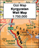
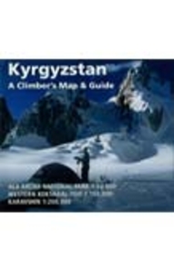
Kyrgyzstan Climbers Map

Detailed maps of 3 selected mountainous regions, noted for their appeal to climbers.1:200, 000 map of the Karavshin Valley, near the tangled borders of south-eastern Kyrgyzstan and Tijikistan.1:150, 000 map of the Western Kokshaal-Too, in the Tien Shan range. (Shown in cartography sample below).1:50, 000 map of the Ala-Archa National Park, south of Bishkek.The maps have been compiled from Russian topographic maps, satellite imagery and ground data. Relief is shown by hill-shading, contours and spot heights. Detail includes passes, peak names, base camps, huts, villages, tracks, roads, borders. Latitude and longitude margin ticks are included, also UTM grid lines on the two larger scale maps.The maps are complemented with information on geography, climbing opportunities and
practical advice for visitors.
RIP - This product is no longer available on our network. It was last seen on 25.09.2019

This page now acts as a permanent archive for this product. Add more information using the comments box below to ensure it can still be found by future generations.

Use our search facility to see if it is available from an alternative contributor.
  • External links may include paid for promotion
  • Availability: Out Of Stock
  • Supplier: Stanfords
  • SKU: 9781933056005
Availability: In Stock
£11.99

Product Description

Detailed maps of 3 selected mountainous regions, noted for their appeal to climbers.1:200, 000 map of the Karavshin Valley, near the tangled borders of south-eastern Kyrgyzstan & Tijikistan.1:150, 000 map of the Western Kokshaal-Too, in the Tien Shan range. (Shown in cartography sample below).1:50, 000 map of the Ala-Archa National Park, south of Bishkek. The maps have been compiled from Russian topographic maps, satellite imagery & ground data. Relief is shown by hill-shading, contours & spot heights. Detail

Includes::
passes, peak names, base camps, huts, villages, tracks, roads, borders. Latitude & longitude margin ticks are included, also UTM grid lines on the two larger scale maps. The maps are complemented with information on geography, climbing opportunities & practical advice for visitors.

Reviews/Comments

Add New

Price History

Vouchers

No voucher codes found.
Do you know a voucher code for this product or supplier? Add it to Insights for others to use.

Facebook

Jargon Buster

Practical - Weather a task is easy to carry out and realistically succeed.
Borders - A line that sometimes can be built up separating off an area, e.g. countries "the welsh boarder"

Supplier Information

Stanfords
Stanfords was established in 1853 and opened their iconic Covent Garden flagship store in 1901. They have become the top retailer of maps, travel books and accessories in the UK and arguably offer the largest selection of maps and travel books worldwide. Famous names such as Captain Robert Falcon Scott, Ranulph Fiennes and Michael Palin have purchased from Stanfords. They now have a shop in Bristol and both stores together with other venues operate a calendar of events including talks, book signings and exhibitions. As a specialist map retailer, the map selection is comprehensive and includes road maps, street maps and walking maps from worldwide destinations, as well as a selection of world atlases and wall maps. Books include travel guides and travel literature. Stanfords also stock globes, from miniatures made of blue marble to magnificent floor-standing globes. The website features a selection of interesting articles on travel topics.
Page Updated: 2023-11-12 20:15:36

Community Generated Product Tags

Oh No! The productWIKI community hasn't generated any tags for this product yet!
Menu