
 United Kingdom
 France
 Germany
 Netherlands
 Sweden
 USA
USA
 Italy
Italy
 Spain
Spain
More From Contributor

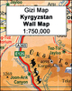

Kyrgyzstan Gizi Map
Kyrgyzstan at 1:750, 000 from Gizi Map with excellent presentation of the country’s mountainous terrain through bold altitude colouring and plenty of names of mountain ranges, etc, road network indicating routes of the old Silk Road, plus a street plan of Bishkek and an administrative map of the country. All place names are in the Latin alphabet.Topography is vividly shown by bold elevation colouring, with spot heights and graphics for swamps, salt flats and deserts, plus plenty of names of mountain ranges, peaks, valleys, etc. National parks are highlighted. The map shows internal provincial boundaries and also clearly indicates the country’s Uzbek and Tadjik enclaves. Road network includes selected local tracks and highlights routes which used to the part of the old Silk
Road. Railway lines are included and local airports are marked. Symbols indicate various places of interest, locations with tourist accommodation including yurt camps, etc. Latitude and longitude lines are drawn at 30’ intervals. The map has on the reverse two separate but cross-referenced indexes, in Latin and Cyrillic script. Map legend includes English.Two panels provide a street plan of central Bishkek annotated with important buildings, selected hotels and places of interest, plus a small administrative map of the country.This title is also available as a wall map.
Road. Railway lines are included and local airports are marked. Symbols indicate various places of interest, locations with tourist accommodation including yurt camps, etc. Latitude and longitude lines are drawn at 30’ intervals. The map has on the reverse two separate but cross-referenced indexes, in Latin and Cyrillic script. Map legend includes English.Two panels provide a street plan of central Bishkek annotated with important buildings, selected hotels and places of interest, plus a small administrative map of the country.This title is also available as a wall map.

Product Description
Reviews/Comments
Add New
Vouchers
No voucher codes found.
Do you know a voucher code for this product or supplier? Add it to Insights for others to use.
Do you know a voucher code for this product or supplier? Add it to Insights for others to use.
 Denmark