
 United Kingdom
 France
 Germany
 Netherlands
 Sweden
 USA
USA
 Italy
Italy
 Spain
Spain
More From Contributor


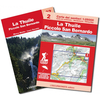


La Thuile – Haute Tarentaise L`Escursionista Editore 01
La Thuile – Haute Tarentaise, map No. 01, in a series of detailed, GPS compatible hiking maps of the Italian Alps from L’Escursionista Editore, highlighting walking routes including the Via Ferrata climbing paths, campsites, refuges, shelters, etc. The map, printed on light waterproof and tear-resistant synthetic paper, is double-sided to provide a wider coverage of the area already presented in this series on sheet No. 2 (La Thuile – Piccolo San Bernardo); cartography and the markings for waymarked trails are the same, but the accompanying booklet contains only colour photos.Maps in this L’Escursionista Editore series have clear, easy to read cartography based on the Italian topographic survey with contours at 25m intervals, enhanced by relief shading, graphic relief
and colouring for glaciers and woodlands. They show numerous spot heights and names of peaks, ridges, glaciers, valleys, etc, with boundaries of national parks or other protected areas prominently marked. The overprint highlighting waymarked hiking trails gives their names and/or official numbers and indicates difficult passages and Via Ferrata climbing paths. The maps also show climbing sites and highlight locations of organized campsites, mountain refuges, bivouac places, hotels and inns/restaurants. Other information includes local unmarked tracks and footpaths, detailed classification of the road network according to widths and surface, roads closed to motorized traffic, railways and mountain transports (cable car lines, chair lifts, etc), car parks, etc. The maps have a
1-km UTM grid, plus latitude and longitude lines at intervals of 5’. Map legend includes English.To see all the titles in this series please click on the series link.

Product Description
Reviews/Comments
Add New
Vouchers
No voucher codes found.
Do you know a voucher code for this product or supplier? Add it to Insights for others to use.
Do you know a voucher code for this product or supplier? Add it to Insights for others to use.
 Denmark