More From Contributor

£9.99
Large, indexed street plan Lagos, with more detailed coverage of Ikeja district, Victoria Island & Lagos isl&. On the main map at 1;35, 000 coverage extends from Victoria Island in the south-east to Abule-Egba district in the north-west & thus comfortably

Includes::
the international airport. Main roads are named, as are districts, & selected locations are indicated e.g. hospitals, estates & markets. The map is indexed for streets & districts. The inset of Ikeja at 1:21, 000 shows access to the airport &, like the Victoria & Lagos Islands, Lekki & Ikoyi map on the reverse,

Includes::
symbols indicating various government offices & other public buildings, embassies, police stations, hospitals & clinics, taxi ranks, shopping centres & markets, hotels, restaurants & petrol stations. The islands area map (1:20, 000, see cartography sample) is indexed for streets & various other locations, e.g. commercial premises, federal offices, hotels & restaurants, police stations, hospitals & petrol stations.


...
Archived Product
£10.99
Road map of the Araucania region covering both sides of border between Argentina & Chile. Coverage extends from the Chilean coast across the border to beyond the main road connecting the towns of Alumine, Junin de Los Andes, San Martin de los Andes, San Carlos de Bariloche & El Boston. The region

Includes::
many national parks & protected areas: on the Chilean side Conguillio, Lago Gualletue, Alto Bio Bio, China Muerta, Villarrica, Huerquehue, Mocho-Choshuenco, Puyehue, Vicente Perez Rosales, & Alerce Andino, & in Argentina Lanin & Nahuel Huapi. The map uses satellite imagery, enhanced with colours & hill-shading to give a vivid representation of the relief. Many local peaks are marked & named. Road network

Includes::
unpaved roads & dirt tracks, with locations of petrol stations & intermediate driving distances on major routes. Railways are marked & symbols show border crossings, hot springs, ranger stations, etc. Latitude & longitude lines are drawn at 30` intervals. Map legend is in Spanish & English. This title is part of the publishers’ series of maps of Patagonia & its most visited regions.


...
Archived Product
£12.00
Lagos is one of the fastest growing cities in the world, expected in some projections to have a population of 25 million by 2025. This will make it the biggest metropolis in sub-Saharan Africa & possibly the world`s third largest city. This phenomenal & continuing growth gives it a heady turbulence, especially as it only took on the form of a coherent urban entity in the eighteenth century. After Nigeria`s independence Lagos remained both trading hub &, for thirty years, a federal capital & political vortex. Now its driving sense of `can-do`, its outreach & vitality, make it a fulcrum & a channel for commercial & cultural talent. Kaye Whiteman explores a city that has constantly re-invented itself, from the first settlement on an uninhabited island to the creation of the port in the early years of the twentieth century. Lagos is still defined by its curious network of islands & lagoons, where erosion & reclamation lead to a permanently shifting topography, but history has thrust it into the role of a burgeoning mega-city, overcoming all nature`s obstacles. The city`s melting-pot has fertilised a unique literary & artistic flowering that is only now beginning to be appreciated by a world that has only seen slums & chaos. COLONIAL CITY: Portuguese influences; the 1861 Treaty of Cession & the British colonialists; architectural traces: schools & government buildings; the move towards independence. CITY OF ENTREPRENEURS: trading through the centuries: Sierra Leoneans & Brazilians; traditional markets & modern malls; the Central Business District. THE CITY OF WORDS & MUSIC: a counterpoint to the alleged philistinism of its businessmen; the views of writers Wole Soyinka & Chinua Achebe; artist & sculptor Ben Enwonwu; the musical genius Fela Kuti. ...
Archived Product
£17.99
The 1:50 000 topographic map gives a more general picture of the ground features than a basic map. It shows settlements, houses, roads, cultivated areas, waterways, cutting areas, mires, rock exposures, & relief. One map sheet covers an area of 30 x 40 km & one centimetre corresponds to 500 metres on the ground. The 1:50, 000 topographic map is also an ideal complement to nautical charts as it provides useful information about the land areas adjacent to waterways. For example, all Finnish sea areas are covered by 1:50 000 topographic map sheets. ...
Archived Product
£12.99
Topographic survey of France at 1:25, 000 in IGN`s excellent TOP25 / Série Bleue series. All the maps are GPS compatible, with a 1km UTM grid plus latitude & longitude lines at 5’ intervals. Contours are at 5m intervals except for mountainous areas where the maps have contours at 10m intervals, vividly enhanced by hill shading & graphics for rocky terrain. Colouring with graphics indicates different types of vegetation or land use (deciduous or coniferous forests, moors, orchards, vineyards, etc). PLEASE NOTE: coverage of France at this scale is currently being revised – the format & the presentation of each title are indicated by the letters at the end of its Sheet Reference number (e.g. 0416ET, 3531ETR, 1923SB, etc.)MAPS WITH FULL TOURIST OVERPRINT & AN ENGLISH MAP LEGEND: all TOP25 maps & the SB editions of Série Bleue have an overprint highlighting waymarked walking trails including long-distance GR routes &, where appropriate, ski routes. Symbols indicate campsites, gîtes d’etape, refuges, equestrian centres & other recreational facilities or sites, tourist information centres, cultural heritage, etc. Towns & locations of particular interest are highlighted.- ET or OT = single-sided TOP25 map covering approx. 29x 21 km / 18x 13 miles.- ETR or OTR = waterproof & tear resistant TOP25 map covering the same area as the corresponding ET or OT number, but double-sided, printed on a smaller size sheet with a good overlap between the sides.- SB = Série Bleue map with full tourist overprint; these maps, first introduced in summer 2014, each cover approx. 29x 24km / 18x 15 miles.SÉRIE BLEUE maps with numbers ending in E (Est) or O (Ouest): most editions now indicate the GR routes, but do not show any other tourist information. Map legend is in French only. Each map covers approx. 14x 20km / 9x 12 miles. ...
Archived Product
£12.50
A 235km long cycle route along the river Lahn from its source to the Rhine. Detailed maps show the route & its variants & extensive information is conveyed by symbols, indicating road surface, campsites & other accommodation, repair workshops, recreational facilities, places of interest, etc. A list of various types of accommodation facilities is included.IMPORTANT
- PLEASE NOTE: ALL THE TEXT IN THIS TITLE IS GERMAN ONLY. MAP LEGEND

Includes::
ENGLISH, please see our sample image, & the information provided on the maps is sufficient to use this title without any knowledge of German, particularly in the absence of a similar product in English from other publishers. There is currently no English edition this title available in this series. About the series: All the titles have been meticulously researched & are highly regarded in their native Germany. Most titles, as indicated in their individual descriptions, also include a separate section listing selected accommodation, from hotels to campsites, youth hostels & rooms in private houses, all with addresses, telephone numbers & price range. Information on towns along each route

Includes::
a list of places of interest, with opening hours, etc. Several of the guides also have street plans.


...
Archived Product
£17.50
Lahn Valley Cycle Route, a 247km long cycle route from the source to the Rhine presented by the Verlag Esterbauer in a guide with maps at 1:50, 000 showing the route & its variants. Extensive information is conveyed by symbols, indicating road surface, campsites & other accommodation, repair workshops, recreational facilities, places of interest, etc. A list of various types of accommodation facilities is included.IMPORTANT
- PLEASE NOTE BEFORE ORDERING
- ALL THE TEXT IN THIS TITLE IS GERMAN ONLY. MAP LEGEND

Includes::
ENGLISH (please see our sample image) & the information provided on the maps is sufficient to use this title without any knowledge of German.ABOUT THE BIKELINE SERIES: all the titles have been meticulously researched & are highly regarded in their native Germany. Most titles, as indicated in their individual descriptions, also include a separate section listing selected accommodation, from hotels to campsites, youth hostels & rooms in private houses, all with addresses, telephone numbers & price range. Information on towns along each route

Includes::
a list of places of interest, with opening hours, etc. Several of the guides also have street plans. To see the list of other titles in the Bikeline series please click on the series link.


...
Archived Product
£11.50
One of the titles in a series of topographic tourist maps covering selected areas in the Rhinel&-Palatinate. All the maps have cartography identical to the standard topographic survey of Germany, with extensive overprint highlighting local footpaths, long-distance paths, & cycle routes, indicating their waymarking. A wide range of symbols show various types of accommodation (campsites, youth hostels, etc), sport & recreational facilities, & places of interest. All maps, unless indicated to the contrary in the individual description, have a UTM grid. Map legend is in German only. Several titles also include descriptions, in German only, of the area covered by the map & its main places of interest, contact details, & coloured photos. Map legend in this title

Includes::
English translation.

...
Archived Product
£10.99
Lahntal on a waterproof, tear-resistant, GPS compatible cycling map at 1:75, 000 from the ADFC (Allgemeiner Deutscher Fahrrad-Club
-
...
Archived Product
£20.95
Unfortunately, the supply of these map has been severely restricted by the Pakistan authorities. When our stocks run out we will not be able to get any more. Main roads & many connecting streets are named on this map but there is no street index. However the map clearly depicts the city's layout of roads & railways, & built-up areas & parks are distinguished. Coverage

Includes::
Shadhara Town. Districts are named & symbols depict mosques, tombs, churches, post offices, some hotels, filling stations & graveyards. Many other notable buildings & public institutions are identified eg.schools, hospitals & cinemas.

...
Archived Product

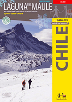
Laguna Del Maule - Winter Trails

Laguna del Maule at 1:35, 000 on a contoured, GPS compatible map form Trekkingchile, printed on light, waterproof and tear-resistant synthetic paper. This is the first map with information on avalanche risks to be published in South America.This ski and snowshoe map shows the area around the Laguna del Maule east of Talca and was developed by the Institute for Cartography at the Dresden Technical University. Using special software which considers key factors as slope, land cover and prevailing wind directions, danger areas have been designated. The 10 snowshoe tours shown in the map are briefly described on the back, a QR code links to the detailed route description in the App Trekkingchile. GPS compatible, with snow-hiking routes, level curves every 50 m, mountain huts,
landscape pictures and drawings of the local fauna. Legend in English and Spanish.Maps in this series features contours are at 50m intervals with colouring and graphics showing different types of vegetation. The map shows local roads, paths and trekking trails, as well as shipping routes on the lakes. Symbols highlight various accommodation facilities (hotels, campsites, refuges), eateries and grocery stores, sport and recreational sites, etc. The map has a 2-km UTM grid, plus margin ticks for latitude and longitude at 1’.Maps in the Trekkingchile series use satellite imagery as a base, with contour lines and colouring to indicate different types of terrain and habitats. Unless indicated to the contrary in the individual descriptions, the maps have a UTM grid, plus margin
ticks for latitude and longitude. The maps are annotated with tourist information and most titles include a street plan of the region’s main town. Many are illustrated with drawings of local fauna or flora. Map legends and other text include English.To see the other titles in this series please click on the series link.
RIP - This product is no longer available on our network. It was last seen on 25.09.2019

This page now acts as a permanent archive for this product. Add more information using the comments box below to ensure it can still be found by future generations.

Use our search facility to see if it is available from an alternative contributor.
  • Availability: Out Of Stock
  • Supplier: Stanfords
  • SKU: 9789568925383
Availability: In Stock
£9.99

Product Description

Laguna del Maule at 1:35, 000 on a contoured, GPS compatible map form Trekkingchile, printed on light, waterproof & tear-resistant synthetic paper. This is the first map with information on avalanche risks to be published in South America. This ski & snowshoe map shows the area around the Laguna del Maule east of Talca & was developed by the Institute for Cartography at the Dresden Technical University. Using special software which considers key factors as slope, land cover & prevailing wind directions, danger areas have been designated. The 10 snowshoe tours shown in the map are briefly described on the back, a QR code links to the detailed route description in the App Trekkingchile. GPS compatible, with snow-hiking routes, level curves every 50 m, mountain huts, landscape pictures & drawings of the local fauna. Legend in English & Spanish. Maps in this series features contours are at 50m intervals with colouring & graphics showing different types of vegetation. The map shows local roads, paths & trekking trails, as well as shipping routes on the lakes. Symbols highlight various accommodation facilities (hotels, campsites, refuges), eateries & grocery stores, sport & recreational sites, etc. The map has a 2-km UTM grid, plus margin ticks for latitude & longitude at 1’. Maps in the Trekkingchile series use satellite imagery as a base, with contour lines & colouring to indicate different types of terrain & habitats. Unless indicated to the contrary in the individual descriptions, the maps have a UTM grid, plus margin ticks for latitude & longitude. The maps are annotated with tourist information & most titles include a street plan of the region’s main town. Many are illustrated with drawings of local fauna or flora. Map legends & other text include English. To see the other titles in this series please click on the series link.

Reviews/Comments

Add New

Intelligent Comparison

Oooops!
We couldn't find anything!
Perhaps this product's unique.... Or perhaps we are still looking for comparisons!
Click to bump this page and we'll hurry up.

Price History

Vouchers

No voucher codes found.
Do you know a voucher code for this product or supplier? Add it to Insights for others to use.

Facebook

Jargon Buster

GPS - Global Positioning System - Global position using satellites
Paper - A thin sheet mainly used for writing. Available in a variety of colours. Made mainly from wood pulp.
Hiking - An outdoor activity envolving walking in nature
Spanish - The main language spoken in Spain and Latin America.
Key - A physical or virtual device or code used for opening something
Graphics - A general term for visual aspects of an item/display
Waterproof - Resistant to water, usualy specified by depth in metres
Km - Kilometre. A unit of measurement equal to 1000 metres.
Resistant - Something that can repel against something.
Snow - Water and vapour in clouds that falls in a white crystal form leaving a white layer.
Accommodation - A room in which someone can live in, for example in a hotel
Winter - The fourth season of a year that comes between Spring and Autumn
technical - Something that relates to a good level of skill and methods.
Individual - A single separate item or person.

Supplier Information

Stanfords
Stanfords was established in 1853 and opened their iconic Covent Garden flagship store in 1901. They have become the top retailer of maps, travel books and accessories in the UK and arguably offer the largest selection of maps and travel books worldwide. Famous names such as Captain Robert Falcon Scott, Ranulph Fiennes and Michael Palin have purchased from Stanfords. They now have a shop in Bristol and both stores together with other venues operate a calendar of events including talks, book signings and exhibitions. As a specialist map retailer, the map selection is comprehensive and includes road maps, street maps and walking maps from worldwide destinations, as well as a selection of world atlases and wall maps. Books include travel guides and travel literature. Stanfords also stock globes, from miniatures made of blue marble to magnificent floor-standing globes. The website features a selection of interesting articles on travel topics.
Page Updated: 2023-11-12 20:15:36

Community Generated Product Tags

Oh No! The productWIKI community hasn't generated any tags for this product yet!
Menu