
 United Kingdom
 France
 Germany
 Netherlands
 Sweden
 USA
USA
 Italy
Italy
 Spain
Spain
More From Contributor


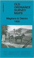
Maghera And District 1900
Maghera and District in 1900 in the Alan Godfrey Edition of historical Ordnance Survey mapping at one inch to one mile. The map is split between Counties Londonderry and Antrim, and covers the area from Maghera and Tobermore eastward to Gracehill and northward to Kilrea. Features include the towns or villages of Ahogill, Kilrea, Maghera, Portglenone and Tobermore, the Moravian settlement of Gracehill, the old Central Derry railway through Maghera, etc. On the reverse is a more detailed map of the centre of Maghera. On the reverse is a detailed village plan for Derrygonnelly, showing the houses lined along the main (only) street; also St Michael`s RC chapel, Fair Green, ruined church, creamery, plus a short directory of the village. The introduction by Séamas Mac Annaidh is in
both English and Irish. *About Alan Godfrey Editions of OS 1” to 1 mile maps of Ireland:*The maps provide an invaluable overview of a wider area, typically 18 x 12 miles (29 x 19kms approx.), and offer historical mapping for small villages not covered by the more detailed series for which the Godfrey Editions are better known. All the maps include historical notes and all, unless indicated in the individual description, also include a large scale map of a small town or village in the area.
both English and Irish. *About Alan Godfrey Editions of OS 1” to 1 mile maps of Ireland:*The maps provide an invaluable overview of a wider area, typically 18 x 12 miles (29 x 19kms approx.), and offer historical mapping for small villages not covered by the more detailed series for which the Godfrey Editions are better known. All the maps include historical notes and all, unless indicated in the individual description, also include a large scale map of a small town or village in the area.

Product Description
Reviews/Comments
Add New
Vouchers
No voucher codes found.
Do you know a voucher code for this product or supplier? Add it to Insights for others to use.
Do you know a voucher code for this product or supplier? Add it to Insights for others to use.
 Denmark