More From Contributor
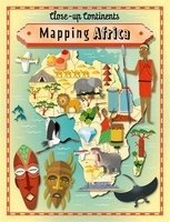
£12.99
Mapominoes Europe, the game that takes you to the edge of the world! This portable, educational, geography game, makes a great present for any family member interested in geography or travel. It’s a great game for 2-5 players that’s fun, easy to learn, educational & highly addictive; like dominoes but with maps, as you build a map of Europe, by connecting countries that share a common border. Stay one step ahead of your opponents, as you race to be the first player to play all your country cards on the table & win the game. Block your opponents by holding on to France or Germany or open up the Baltic States by playing Russia. Take a boat through the North Sea to the United Kingdom or transit by train through Spain to Portugal. Try not to get stuck with San Marino, or landlocked with Liechtenstein as you watch the country cards spread across the table. The excitement builds as you have fewer & fewer cards left to play, but less space to play them in as you reach the edge of the world- the table’s edge. Every country card is different due to their varying border connections & hence no two games are ever the same in this clever game that you will want to play again & again. A simple game with hidden strategic depth that gives it broad appeal to both children & adults. Suitable for age 8 to adult. ...
Archived Product
£12.99
Mapominoes UK is a portable game is fun, easy to learn, educational & highly addictive & makes a great present for any family member interested in geography or travel. It’s like dominoes but with maps, as you build a map of the UK, by connecting counties that share a common border. Stay one step ahead of your opponents, as you race to be the first player to play all your county cards on the table & win the game. Every country card is different due to their varying border connections & hence no two games are ever the same in this clever game that you will want to play again & again. Play as a stand alone game or combine with Mapominoes games for other continents to make to expand the game to cover the world.A simple game with hidden strategic depth that gives it broad appeal to both children & adults. ...
Archived Product
£12.99
MAPOMINOES USA – The game that takes you to the 4 corners of the country!A fantastic game for 2-5 players that’s fun, easy to learn, educational & highly addictive. It’s like dominoes but with maps, as you build a map of the USA, by connecting states that share a common border. Stay one step ahead of your opponents, as you race to be the first player to play all your state cards on the table & win the game. Block access to the Southern States by holding on to Virginia or Kentucky or open up New England by playing New York. Take a boat up through the Pacific Ocean to Alaska or transit by train through Texas to Louisiana. Try not to get cut off in California, marooned with Maine or stuck with South Carolina, as the state cards spread across the table. The excitement builds as you have fewer & fewer cards left to play, but less space to play them in as you reach the table’s edge! Every state card is different & hence no two games are ever the same in this clever game that you will want to play again & again. Contents: 51 State or Territory cards, 12 transit cards, sand timer, rules. Age 8 + ...
Archived Product
£17.95
The Mappa Mundi, arguably the most famous of all medieval world maps, is now on display in Hereford Cathedral. This book was commissioned to mark the map's display in a newly-built museum, & the map is seen here in context with other detailed maps of the 12th to the 14th centuries; at that period these were a peculiarly English genre, on which recent discoveries have thrown new light. The map's origins are examined, as well as the sources for its geographical outlines, & for the wealth of information it provides. This account, intended for a general audience, is of one of the most revealing artefacts surviving from the 13th century. The book

Includes::
new photography of the map itself.

...
Archived Product
£10.95
The Mappa Mundi, arguably the most famous of all medieval world maps, is now displayed in Hereford Cathedral. This book was commissioned to mark the map's display in a newly-built museum, & the map is here seen in context with other detailed maps of the 12th to the 14th centuries; at that period these were a peculiarly English genre, on which recent discoveries have thrown new light. The map's origins are examined, as well as the sources for its geographical outlines, & for the wealth of information it provides. This account, intended for a general audience, is of one of the most revealing artefacts surviving from the 13th century. The book

Includes::
new photography of the map itself.

...
Archived Product
£24.95
Following on from ” Mapping New York” & ” Mapping London, ” ” Mapping America: Exploring the Continent” takes a similar approach in its presentation, thematically arranging a vivid collection of historic, demographic, cultural & artistic maps to aid the reader on their journey. Featuring four centuries of maps that depict the changing landscape of North America, ” Mapping America” charts the continent through numerous landmark events & uprisings, including the Civil War, the Civil Rights Movement, & more recent concerns, such as the environment & terrorism. From early maps depicting the country`s colonial beginnings, through to contemporary maps depicting America today, the book presents the reader with a multi-faceted view of the North American physical & cultural landscape; from maps showing the electoral routes of Presidential campaigns, to the diminishing native communities shown in census maps, to maps charting the country`s health statistics. Alongside the historic, geographic, & political, the book also pays particular attention to the artistic & imaginative, documenting America`s rich & descriptive literary & artistic past. The journey taken by Jack Kerouac in the seminal book ” On the Road” is documented in a h&-drawn map, whilst numerous artists known for their interest in cartography will be featured, from the representational to the abstract, including Paula Scher with ” The United States” & Daniel Medina with ” Map Cube World.” Not just for cartography enthusiasts, ” Mapping America: Exploring the Continent” appeals to the general reader, as well as specialists in the areas of geography, art, architecture & design. The book`s breadth of material, with a variety of maps ranging from the historically accurate to the imaginative & entertaining, makes it accessible to all, & a perfect Christmas gift. ...
Archived Product
£21.50
There are two parts to this history of the British surveys of India. First the author presents a detailed survey of cartographic techniques in the 18th & early 19th centuries & the institutional structures of the East India Company. Then there is an analysis of the importance of mapping to the British Empire, not just to define it spatially but also to give it legitimacy. Draws extensively upon the records of the British East India Company & other primary sources.” There is much to be praised in this book. It is an excellent history of how India came to be painted red in the nineteenth century. But more importantly, mapping an Empire sets a new standard for books that examine a fundamental problem in the history of European imperialism.”
- D Graham Burnett Times Literary Supplement
...
Archived Product
£40.00
Almost thirty years after the Apollo missions, Tranquillity Base, Hadley Rille, or Taurus-Littrow are names still resonant with the enormous achievements represented by the lunar landings. But how did these places get their names? Who named Copernicus crater? Where did all those names on lunar maps come from, & what stimulated their selection? Ewen Whitaker traces the origins & evolution of the present-day systems for naming lunar features such as craters, mountains, valleys & dark spots. The connections between the prehistoric & historic names, & today's gazetteer are clearly described. Beautiful lunar maps spanning four centuries of progress wonderfully illustrate the unfolding of our ability to map the Moon. Rare, early photographs add to the sense of history. Comprehensive appendices & the bibliography make this delightful book a work of lasting reference & scholarship. ...
Archived Product
£12.99
This unique series gets close up to some amazing areas of our world, & allows readers the opportunity to explore key countries, topographical features & cities in a way that is both engaging & entertaining. In addition, each book highlights significant human, geographical, sporting & economic information. ...
Archived Product
£40.00
Mapping England shows, through a series of compelling maps
- both historic & contemporary
- how England has scrutinized itself,

...
Archived Product

Mapping Africa

This unique series gets close up to some amazing areas of our world, and allows readers the opportunity to explore key countries, topographical features and cities in a way that is both engaging and entertaining. In addition, each book highlights significant human, geographical, sporting and economic information.
RIP - This product is no longer available on our network. It was last seen on 25.09.2019

This page now acts as a permanent archive for this product. Add more information using the comments box below to ensure it can still be found by future generations.

Use our search facility to see if it is available from an alternative contributor.
  • Availability: Out Of Stock
  • Supplier: Stanfords
  • SKU: 9781445141114
Availability: In Stock
£12.99

Product Description

This unique series gets close up to some amazing areas of our world, & allows readers the opportunity to explore key countries, topographical features & cities in a way that is both engaging & entertaining. In addition, each book highlights significant human, geographical, sporting & economic information.

Reviews/Comments

Add New

Intelligent Comparison

Oooops!
We couldn't find anything!
Perhaps this product's unique.... Or perhaps we are still looking for comparisons!
Click to bump this page and we'll hurry up.

Price History

Vouchers

No voucher codes found.
Do you know a voucher code for this product or supplier? Add it to Insights for others to use.

Facebook

Jargon Buster

Key - A physical or virtual device or code used for opening something
Human - A highly developed and adapted mamal and deminant species on earth
World - A physical grouping, commonly used to describe earth and everything associated with ti

Supplier Information

Stanfords
Stanfords was established in 1853 and opened their iconic Covent Garden flagship store in 1901. They have become the top retailer of maps, travel books and accessories in the UK and arguably offer the largest selection of maps and travel books worldwide. Famous names such as Captain Robert Falcon Scott, Ranulph Fiennes and Michael Palin have purchased from Stanfords. They now have a shop in Bristol and both stores together with other venues operate a calendar of events including talks, book signings and exhibitions. As a specialist map retailer, the map selection is comprehensive and includes road maps, street maps and walking maps from worldwide destinations, as well as a selection of world atlases and wall maps. Books include travel guides and travel literature. Stanfords also stock globes, from miniatures made of blue marble to magnificent floor-standing globes. The website features a selection of interesting articles on travel topics.
Page Updated: 2023-11-12 20:15:36

Community Generated Product Tags

Oh No! The productWIKI community hasn't generated any tags for this product yet!
Menu