More From Contributor

£19.95
Illustrating the changing shape of the Americas as Renaissance cartographers (working from ancient & medieval sources) learned more of the New World, this collection is the third in a series produced by Scala, which showcases the core collections of the American Museum in Britain. Dr. Dallas Pratt, an American psychiatrist & collector, donated over 200 exquisitely detailed maps to the American Museum in Britain, until his death in 1994. This gift is acclaimed by map scholars as the finest private holding of pre-1600 printed world maps on this side of the Atlantic. Spurred on by thoughts of treasure
- particularly gold, silver, gems & spices
- European travellers changed the shape of the New World as they mapped the Americas from the 15th to the 17th centuries. Whereas medieval maps illustrated theology rather than geography, the Renaissance revived the classical discipline of scientifically mapping land mass. Such precision was entirely practical: only by exact measurement could the rich New World territories be claimed, plundered & ruled by its Old World conquerors.

...
Archived Product
£9.99
` Patsy, what are you going to be when you grow up? Well?` `A Royal Engineer, Daddy. A Royal Engineer!` Charles Drazin knew little about his mother`s father
- only that he had been a military surveyor who mapped great swathes of the British Empire. But when his mother was told that she was dying, it prompted recollections of her early life that she had never confided before: of the village in the west of Ireland where she had grown up, & of her father, whose death changed the life of an eight-year-old girl for ever. Soon afterwards her own death left her son to go through alone the relics of her life. They included a box of old photographs, a battered suitcase stamped with the initials of the grandfather he had never known, & the service records of Patrick`s brothers, who, like him, had all enlisted in the Royal Engineers as the nineteenth century became the twentieth. So began an extraordinary journey of discovery that took him from the age of Queen Victoria to the battlefields of the Western Front. Mapping the Past is the story of five brothers who, mapping the world, lived up to the Royal Engineers` motto of Everywhere. It is the story of Irel&, & of the Empire from which it broke away. It is the story of conflict, war & its aftermath. &, most of all, it is the story of memory, endlessly carrying the past, for better or worse, into our present & future. It is an imaginative, intimate & powerful work of history, by a writer of rare power.
...
Archived Product
£30.00
With “ Mapping the Railways” you can follow the development, decline & revival of Britain’s railways through a unique collection of old & new maps, commentaries & photographs. The story is traced from early ‘waggonways’ through the steam era to today’s diesel & electric railways. This lovely hardback book features over a hundred railway maps, with examples of almost every type of topographical map available throughout the nineteenth & twentieth centuries, including some of Stanfords own from our map-making heyday! Alongside each of the maps are a series of ‘milepost’ features which give a detailed description of key events, eras & personalities in the history of Britain’s railways. This an ideal read for lovers of trains, maps, & the past alike. ...
Archived Product
£16.99
Follow the development, decline & revival of Britain's railways through a unique collection of old & new maps, commentaries & photographs. Charting the rich history of Britain's railways from 1819 to the present day, this fascinating compendium shows how trains have played an essential part in British life for nearly 200 years. Throughout this engaging book is a series of 'milepost' features on key events, eras & personalities in the history of Britain's railways. From the enormous role the railways played in the World Wars to modern events, like the opening of the Channel Tunnel, this extensive book shows you how British history is firmly tied to the railways. The story is traced from early 'waggonways', through the steam era to today's diesel & electric railways. Mapping the Railways will appeal to railway enthusiasts, historians & general interest readers alike. Over 100 railway maps: Historical & modern rail network maps Extracts from Ordnance Survey sheets Plans for proposed railway schemes Track diagrams & official reports Pictorial maps, posters & ephemera Cartography by Bartholomew, Airey, Bradshaw & many others Pivotal events in railway history: The nineteenth century saw the foundations laid for our modern railway network, with huge building projects constructing thousands of miles of track, bridges & tunnels Expansion slowed in the early twentieth century as competition from the car & the lorry began to bite Railways made an enormous contribution to the World Wars, then underwent massive re-equipment after nationalization Drastic change followed the ' Beeching Report' of 1963, which advocated closure of underused rail lines The modern era has seen an expansion of the network again, with the building of the Channel Tunnel & the re-opening of a significant number of lines closed under the ' Beeching axe', many as heritage railways. ...
Archived Product
£25.00
A history of mapping Britain`s roads. The story of Britain`s road development
- graphically & beautifully illustrated on our maps
...
Archived Product
£30.00
Follow the conflict of the Second World War from 1939 to 1945 in this unique volume, published in association with Imperial War Museums, London, featuring historical maps & photographs from their archives, & fascinating commentary from an expert historian. Over 150 maps tell the story of how this global war was fought. Types of maps featured: Strategic maps showing theatres of war, frontiers & occupied territories. Maps covering key battles & offensives on major fronts. Planning & operations maps showing defences in detail. Propaganda & educational maps for the armed forces & general public. Maps showing dispositions of Allied & enemy forces. Bomber & V-weapon target maps Descriptions of key historical events accompany the maps, giving an illustrated history of the war from an expert historian. Key topics covered include:1939: Invasion of Pol&. 1940: German invasion of Low Countries & France.1940: Battle of Britain & German invasion threat. Dec 1941: Pearl Harbor.1942: Turning points: Midway, Alamein, Stalingrad.1941-45: Barbarossa & the Eastern Front. The War at Sea. The advances to Jerusalem, Damascus & Baghdad. The War in the Air.1944: Neptune & Overlord; D-Day & liberation of France. ...
Archived Product
£20.00
The Second World War was a watershed in world history: the seizing of power by Hitler & the Nazis, the slowly building crescendo of annexations that led to Blitzkrieg, the conquest of Europe, the U-boat war, the strategic bombing campaign, the invasion of Russia, Stalingrad & D-Day, & the long German retreat to unconditional surrender. Mapping the Second World War does not try to retell every point in the story of the war in Europe, rather it seeks to provide
- through contemporary documents
- a different view of the war & suggest avenues for further research. Presenting over 100 maps it looks both at the broad sweep of events
- such as the invasion of Europe in June 1944
- & at details
- the two-man X-craft attack on the battleship Tirpitz
- to provide a fascinating sample of how events during the war were mapped out. Charts & maps were vital to the conduct of the war: before each military event there was planning, the reconnaissance, the conjecture as to enemy dispositions: after the event there would be debriefing, analysis of success & failure, & a redrawing of maps to show new troop positions & boundaries. Many of the maps selected have been used in actual combat & are marked up accordingly. Such battlefield annotations add to this fascinating overview of some of the key events in the Second World War & are referenced in the extended accompanying map captions. The volume is complete with a detailed narrative introduction to the progress of the war.


...
Archived Product
£29.95
Mapping Asia presents an authoritative selection of the most important antique maps of Asia & the Middle East produced from the time of Alexander the Great to the early nineteenth century, by cartographers from Engl&, France, Portugal, Holl&, Turkey, Italy, & China. A fascinating visual chronicle of the maps & their makers, this book explores the history of Europe`s discovery of lands to the east, from Constantinople to present-day Alaska. It tells the stories of the thriving trade that linked east & west beginning with the ancient Silk Road, the explorers
- such as Magellan & Sir Francis Drake
- who continually searched for new lands & routes to reach the east beginning in the fifteenth century, & the indigenous peoples who struggled to retain their autonomy in the face of European missionary activity & influence. Mapping Asia reproduces in full color 80 beautifully rendered & rare maps, more than 40 of which have never been published for the general public. Each map is accompanied by an accessible essay that provides extensive background on the mapmaker & how the map was originally produced, & describes the geography, sites, & details on the map. Most

...
Archived Product
£19.95
Today the world is focusing unprecedented attention on Asia & the Middle East
- rediscovering a cultural, political, & geographical
...
Archived Product
£30.00
” Mapping the Universe: the Interactive History of Astronomy” is the story of man`s quest through the ages to unlock the secrets of our universe, understand where we come from & where we are going. Lavishly illustrated throughout, it follows this journey for knowledge from the first musings of Stone Age people on the position of the stars & planets in the sky, to Galileo`s first visions of Orion through a telescope, to our first steps on the moon, & right up to the photographs of our magnificent universe which are being sent back from the Plank telescope today. Beautifully reproduced documents make it possible for the reader to experience hands-on, & appreciate at each stage, what over ten thousand years of history astronomers were discovering, & how & why this was significant. ...
Archived Product

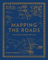
Mapping The Roads: Building Modern Britain

The story of Britain`s road development - graphically and beautifully illustrated on our maps - is also the story of its political, economic and social history. And the car, more than any other single factor, has shaped our landscape andchanged our maps. Busy, bustling, often creaking at the seams, most of us have a love-hate relationship with our roads. Like it or not, our modern lifestyles depend on them - not only for getting there from A to B, but for the distribution ofalmost everything we buy. Yet once upon a time, the building of roads was seen as a glorious and heroic enterprise. Britain`s motorways - `the cathedrals of the modern world` - are the ultimate expression of our modern age. From the old ways to the motorways, Mapping the Roads, charts the ambitions and hopes
of the nation through our maps.
RIP - This product is no longer available on our network. It was last seen on 25.09.2019

This page now acts as a permanent archive for this product. Add more information using the comments box below to ensure it can still be found by future generations.

Use our search facility to see if it is available from an alternative contributor.
  • Availability: Out Of Stock
  • Supplier: Stanfords
  • SKU: 9780749578237
Availability: In Stock
£14.99

Product Description

The story of Britain`s road development
- graphically & beautifully illustrated on our maps
- is also the story of its political, economic & social history. & the car, more than any other single factor, has shaped our landscape andchanged our maps. Busy, bustling, often creaking at the seams, most of us have a love-hate relationship with our roads. Like it or not, our modern lifestyles depend on them
- not only for getting there from A to B, but for the distribution ofalmost everything we buy. Yet once upon a time, the building of roads was seen as a glorious & heroic enterprise. Britain`s motorways
- `the cathedrals of the modern world`
- are the ultimate expression of our modern age. From the old ways to the motorways, Mapping the Roads, charts the ambitions & hopes of the nation through our maps.

Reviews/Comments

Add New

Intelligent Comparison

Oooops!
We couldn't find anything!
Perhaps this product's unique.... Or perhaps we are still looking for comparisons!
Click to bump this page and we'll hurry up.

Price History

Vouchers

No voucher codes found.
Do you know a voucher code for this product or supplier? Add it to Insights for others to use.

Facebook

Jargon Buster

History - Anything that happens in the past. An acedemic subject.
World - A physical grouping, commonly used to describe earth and everything associated with ti
Car - A machine used for transport which runs on roads
Love - Someone who shows deep affection for someone else.
Road - a manmade lane or a path that is used to speed up travel.

Supplier Information

Stanfords
Stanfords was established in 1853 and opened their iconic Covent Garden flagship store in 1901. They have become the top retailer of maps, travel books and accessories in the UK and arguably offer the largest selection of maps and travel books worldwide. Famous names such as Captain Robert Falcon Scott, Ranulph Fiennes and Michael Palin have purchased from Stanfords. They now have a shop in Bristol and both stores together with other venues operate a calendar of events including talks, book signings and exhibitions. As a specialist map retailer, the map selection is comprehensive and includes road maps, street maps and walking maps from worldwide destinations, as well as a selection of world atlases and wall maps. Books include travel guides and travel literature. Stanfords also stock globes, from miniatures made of blue marble to magnificent floor-standing globes. The website features a selection of interesting articles on travel topics.
Page Updated: 2023-11-12 20:15:36

Community Generated Product Tags

Oh No! The productWIKI community hasn't generated any tags for this product yet!
Menu