More From Contributor

£8.99
Guy Browning was weaned on, educated by & to this day remains utterly in love with maps, so it`s only right that the story of his life should also be the story of his favourite maps. In this little comic masterpiece, a series of quirky cartographic gems chart his unsteady progress from birthplace Chipping Norton, `the golden navel of the universe`, through his starting position as second son
- ` Second children are like second marriages: you know that in general they`re worth having but you`ve also learned from your first how messy & unpleasant they can be`
- & then round the world via the Alps, the American West & the heat & dust of El Salvador
- ` It is to that fine country I owe my abiding love for all things Hispanic & my deep dislike for porridge`.


...
Archived Product
£20.00
People everywhere share some kind of nostalgia for an innocence experienced at the beginning of history & look forward to a joy promised at the end of time, meanwhile searching for contemporary happiness. For two millennia, learned Christians have wondered where on earth could the primal paradise have been located? Where was the idyllic Garden of Eden that is described in the Bible? Where were Adam & Eve created in their unspoiled perfection? Scholars early rose to the challenge to identify the place on a map of the world, despite the certain knowledge that it was unreachable. Maps of Paradise charts the diverse ways in which they were led to depict the Garden of Eden on maps from Late Antiquity to the twenty-first century. It is the history of a paradox: the mapping of the unmappable. It is also a mirror to the universal dream of perfection & the yearning to find heaven on earth. ...
Archived Product
£10.99
Othman al-Sheikh is running away from the shadows of his past life in a small dusty village in the Libyan Desert. Tripoli, meanwhile, is a city in the process of transformation, moulded to the will of its Italian colonisers. Its decadent entertainments & extravagant riches conceal an underbelly of abject poverty & ruthless plotting. Othman falls for the city & its temptations. With a natural instinct for survival, he tries his luck in the capital, swept along by chance & opportunity. Set in the early 1930s, Maps of the Soul immerses the reader in a different Libya, a country emerging from fierce resistance wars & presided over by the charismatic colonialist Italo Balbo with his dreams of a new Rome on the Fourth Shore, the crowning glory of the fascist dream. Against this backdrop, the story unfolds, one of painful survival in the face of defeated dreams. This volume contains the first three books of Fagih`s monumental twelve part work, ending as Othman finally leaves Tripoli behind, a city at the mercy of political wrangling & war. ...
Archived Product
£17.99
Take a tour of the United Kingdom as you`ve never seen it before in this fully illustrated set of county maps. Travel through Engl&, Northern Irel&, Scotland & Wales & meet the incredible people born there, learn about its proud history, & discover ancient castles, modern feats of engineering & natural highlights while you revel in the nation`s curiosities, from the spectacular, to the quirky, to the downright strange! A fabulous introduction to Shakespeare`s Sceptre Isle, for readers young & old. ...
Archived Product
£17.99
Covering every continent, country, even outer space, MAPS OF THE WORLD is a vibrant & comprehensive atlas that children of all ages will love to explore. The dozens of colorful, detailed maps are filled with charming, educational icons representing the aboriginal people in Australia, giant tortoises in the Galapagos, the Gold Rush in California, traditional dress in Mali, & even James Bond in Engl&. Flip the next page in the book, & the corresponding icon key explains hundreds of these cultural, environmental, & societal illustrations. Organized by continent, the atlas also

Includes::
details on populations, language, agricultural, politics, & other bite-size facts. Each map

Includes::
a link allowing kids to download a version of them on computers & tablets to explore even further. Captivating & comprehensive, MAPS OF THE WORLD will entice even the most reluctant young explorer.


...
Archived Product
£30.00
There is little documented mapping of conflict prior to the Renaissance period, but, from the 17th century onwards, military commanders & strategists began to document the wars in which they were involved & later, to use mapping to actually plan the progress of a conflict. Using contemporary maps, this sumptuous new volume covers the history of the mapping of war on land & shows the way in which maps provide a guide to the history of war. Content
Includes:: The beginnings of military mapping up to 1600 including the impact of printing & the introduction of gunpowder The seventeenth century: The focus is on maps to illustrate war, rather than as a planning tool & the chapter considers the particular significance of maps of fortifications. The eighteenth century: The growing need for maps on a world scale reflects the spread of European power & of transoceanic conflict between Europeans. This chapter focuses in particular on the American War of Independence. The nineteenth century: Key developments included contouring & the creation of military surveying. Subjects include the Napoleonic Wars & the American Civil War The twentieth century including extended features on the First & Second World Wars including maps showing trench warfare & aerial reconnaissance. Much of the chapter focuses on the period from 1945 to the present day including special sections on the Vietnam War & the Gulf Wars.
...
Archived Product
£25.00
Explore the world with this lavish new edition of the bestselling Maps. Released to mark the 10th anniversary of the very first edition, this book features 16 brand new maps & has new material on every page. Each highly illustrated map details not only geographical features & political borders but also places of interest, iconic personalities, native animals & plants, local peoples, cultural events, & many more fascinating facts assorted with each region. It`s a celebration of the world, from its immense mountains to its tiny insects
- & everything in between!
...
Archived Product
£13.50
This assessment of the role of cartography in American journalism traces the use of news maps in newspapers & magazines & on television from the 18th century to the 1980s. Monmonier examines the technological innovations that have made possible the widespread use of maps, & assesses the political & economic factors that have inspired journalists to exploit the new technologies. ...
Archived Product
£9.99
PEPIN gift & creative paper books all contain 4 pages of introduction & 12 large sheets of very high-quality wrapping paper. They can easily be removed from the books by tearing them along a perforated line. The wrapping papers are folded to fit into the book; when removed & opened they measure 50 cm x 70 cm (19 inch x 27 inch; a standard size for gift wrapping papers). Depending on the theme, we have selected a suitable light-weight paper quality. For example, papers with designs in gold, silver or bronze are printed on silky art paper on which the inks show to their best advantage. Designs with an antique or h&-made feel are printed on high-quality creamy offset paper. PEPIN papers make your gift package look very special. In addition, our papers are suitable for scrap booking & all sorts of craft projects. Each volume contains 12 different, exceptional designs. ...
Archived Product

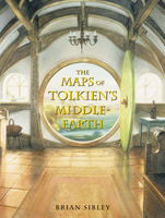
Maps Of Tolkien`s Middle-earth

Available together for the first time, Tolkien`s Maps of The Hobbit, Beleriend and Middle-earth are beautifully presented in an exquisite box-set illustrated by John Howe. This special edition includes a unique map of Numenor. Written by the writer and broadcaster Brian Sibley, a foremost expert on The Lord of the Rings (he adapted the novel for the award-winning BBC radio dramatisation in 1980), this slipcase features Tolkien`s Maps of The Hobbit, Beleriand and Middle-earth, available together for the first time. Each map is a real labour of love, presented in a box-set stunningly illustrated by world-renowned Tolkien artist John Howe, the conceptual artist employed by Peter Jackson to work on his $300 million Lord of The Rings film trilogy. The maps, presented with individual
books and wallets, are larger than those previously published, showing Tolkien`s mythical lands in perfect detail - they are also expertly bound with fewer folds, making them perfect for portfolios or framing.
RIP - This product is no longer available on our network. It was last seen on 25.09.2019

This page now acts as a permanent archive for this product. Add more information using the comments box below to ensure it can still be found by future generations.

Use our search facility to see if it is available from an alternative contributor.
  • Availability: Out Of Stock
  • Supplier: Stanfords
  • SKU: 9780007169702
Availability: In Stock
£30.00

Product Description

Available together for the first time, Tolkien`s Maps of The Hobbit, Beleriend & Middle-earth are beautifully presented in an exquisite box-set illustrated by John Howe. This special edition

Includes::
a unique map of Numenor. Written by the writer & broadcaster Brian Sibley, a foremost expert on The Lord of the Rings (he adapted the novel for the award-winning BBC radio dramatisation in 1980), this slipcase features Tolkien`s Maps of The Hobbit, Beleriand & Middle-earth, available together for the first time. Each map is a real labour of love, presented in a box-set stunningly illustrated by world-renowned Tolkien artist John Howe, the conceptual artist employed by Peter Jackson to work on his $300 million Lord of The Rings film trilogy. The maps, presented with individual books & wallets, are larger than those previously published, showing Tolkien`s mythical lands in perfect detail
- they are also expertly bound with fewer folds, making them perfect for portfolios or framing.

Reviews/Comments

Add New

Intelligent Comparison

Oooops!
We couldn't find anything!
Perhaps this product's unique.... Or perhaps we are still looking for comparisons!
Click to bump this page and we'll hurry up.

Price History

Vouchers

No voucher codes found.
Do you know a voucher code for this product or supplier? Add it to Insights for others to use.

Facebook

Jargon Buster

Radio - A device used for listening to audio transmissions
World - A physical grouping, commonly used to describe earth and everything associated with ti
Earth - A planet third from the sun. Similar size to Venus but rich in water and complex life.
Set - a group of items usually related to one another. Some objects cannot function without the complete set of items.
Love - Someone who shows deep affection for someone else.
Individual - A single separate item or person.

Supplier Information

Stanfords
Stanfords was established in 1853 and opened their iconic Covent Garden flagship store in 1901. They have become the top retailer of maps, travel books and accessories in the UK and arguably offer the largest selection of maps and travel books worldwide. Famous names such as Captain Robert Falcon Scott, Ranulph Fiennes and Michael Palin have purchased from Stanfords. They now have a shop in Bristol and both stores together with other venues operate a calendar of events including talks, book signings and exhibitions. As a specialist map retailer, the map selection is comprehensive and includes road maps, street maps and walking maps from worldwide destinations, as well as a selection of world atlases and wall maps. Books include travel guides and travel literature. Stanfords also stock globes, from miniatures made of blue marble to magnificent floor-standing globes. The website features a selection of interesting articles on travel topics.
Page Updated: 2023-11-12 20:15:36

Community Generated Product Tags

Oh No! The productWIKI community hasn't generated any tags for this product yet!
Menu