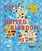
More From Contributor

£17.99
Take a tour of the United Kingdom as you`ve never seen it before in this fully illustrated set of county maps. Travel through Engl&, Northern Irel&, Scotland & Wales & meet the incredible people born there, learn about its proud history, & discover ancient castles, modern feats of engineering & natural highlights while you revel in the nation`s curiosities, from the spectacular, to the quirky, to the downright strange! A fabulous introduction to Shakespeare`s Sceptre Isle, for readers young & old. ...
Archived Product
£17.99
Covering every continent, country, even outer space, MAPS OF THE WORLD is a vibrant & comprehensive atlas that children of all ages will love to explore. The dozens of colorful, detailed maps are filled with charming, educational icons representing the aboriginal people in Australia, giant tortoises in the Galapagos, the Gold Rush in California, traditional dress in Mali, & even James Bond in Engl&. Flip the next page in the book, & the corresponding icon key explains hundreds of these cultural, environmental, & societal illustrations. Organized by continent, the atlas also

Includes::
details on populations, language, agricultural, politics, & other bite-size facts. Each map

Includes::
a link allowing kids to download a version of them on computers & tablets to explore even further. Captivating & comprehensive, MAPS OF THE WORLD will entice even the most reluctant young explorer.


...
Archived Product
£30.00
Available together for the first time, Tolkien`s Maps of The Hobbit, Beleriend & Middle-earth are beautifully presented in an exquisite box-set illustrated by John Howe. This special edition

Includes::
a unique map of Numenor. Written by the writer & broadcaster Brian Sibley, a foremost expert on The Lord of the Rings (he adapted the novel for the award-winning BBC radio dramatisation in 1980), this slipcase features Tolkien`s Maps of The Hobbit, Beleriand & Middle-earth, available together for the first time. Each map is a real labour of love, presented in a box-set stunningly illustrated by world-renowned Tolkien artist John Howe, the conceptual artist employed by Peter Jackson to work on his $300 million Lord of The Rings film trilogy. The maps, presented with individual books & wallets, are larger than those previously published, showing Tolkien`s mythical lands in perfect detail
- they are also expertly bound with fewer folds, making them perfect for portfolios or framing.


...
Archived Product
£30.00
There is little documented mapping of conflict prior to the Renaissance period, but, from the 17th century onwards, military commanders & strategists began to document the wars in which they were involved & later, to use mapping to actually plan the progress of a conflict. Using contemporary maps, this sumptuous new volume covers the history of the mapping of war on land & shows the way in which maps provide a guide to the history of war. Content
Includes:: The beginnings of military mapping up to 1600 including the impact of printing & the introduction of gunpowder The seventeenth century: The focus is on maps to illustrate war, rather than as a planning tool & the chapter considers the particular significance of maps of fortifications. The eighteenth century: The growing need for maps on a world scale reflects the spread of European power & of transoceanic conflict between Europeans. This chapter focuses in particular on the American War of Independence. The nineteenth century: Key developments included contouring & the creation of military surveying. Subjects include the Napoleonic Wars & the American Civil War The twentieth century including extended features on the First & Second World Wars including maps showing trench warfare & aerial reconnaissance. Much of the chapter focuses on the period from 1945 to the present day including special sections on the Vietnam War & the Gulf Wars.
...
Archived Product
£13.50
This assessment of the role of cartography in American journalism traces the use of news maps in newspapers & magazines & on television from the 18th century to the 1980s. Monmonier examines the technological innovations that have made possible the widespread use of maps, & assesses the political & economic factors that have inspired journalists to exploit the new technologies. ...
Archived Product
£9.99
PEPIN gift & creative paper books all contain 4 pages of introduction & 12 large sheets of very high-quality wrapping paper. They can easily be removed from the books by tearing them along a perforated line. The wrapping papers are folded to fit into the book; when removed & opened they measure 50 cm x 70 cm (19 inch x 27 inch; a standard size for gift wrapping papers). Depending on the theme, we have selected a suitable light-weight paper quality. For example, papers with designs in gold, silver or bronze are printed on silky art paper on which the inks show to their best advantage. Designs with an antique or h&-made feel are printed on high-quality creamy offset paper. PEPIN papers make your gift package look very special. In addition, our papers are suitable for scrap booking & all sorts of craft projects. Each volume contains 12 different, exceptional designs. ...
Archived Product
£30.00
Maps: Their Untold Stories, a magnificent collection drawn from seven centuries of maps held in the National Archives at Kew, presents a variety of maps, from those found in 14th Century manuscripts, through early estate maps, to sea charts, maps used in military campaigns, & maps from treaties. The text explores who the mapmakers were, the purposes for which the maps were made, & what it tells us about the politics of the time. Maps are snapshots of a place, a city, a nation or even the world at a given point in time
- fascinating for what they tell us about the way our ancestors saw themselves, their neighbours & their place in the world. In this beautiful collection great images are accompanied by compelling stories. Featured is a woodcut map of 16th Century London, a map of where the bombs fell during the Second World War, & a map the first American settlers` drew when they were attempting to establish a new empire on Roanoke Island off the coast of what is now North Carolina. Richly illustrated with large scale reproductions of the maps, the book also

Includes::
some of the more amusing or esoteric maps from the National Archives, such as the map of the Great Exhibition in 1851 that was presented on a lady`s glove, a London Underground map in the form of a cucumber, & a Treasure Island map used to advertise National Savings. This is a fascinating & unusual journey through the world of maps & mapmakers.


...
Archived Product
£41.99
Mapstart 1 Copymasters CD contains a set of 40 pages of outlines of drawings, plans & maps used in Mapstart 1, the accompanying core book. These can be used to give additional practice in the skills introduced in Mapstart 1. Teachers notes included, outline the focus of the copymaster & the National Curriculum aspects covered. In developing children's understanding of & skills in using maps it is essential that they explore & examine maps not only through reading & studying but also by recording on, adding to, completing & creating maps. Mapstart 1 Copymasters CD has been developed as a vital extension to Mapstart 1. It provides further activities to reinforce ideas & skills introduced in Mapstart 1, & introduces new ideas & skills to the children. The copymasters refer both to the maps & photographs in Mapstart 1 & provide new material for the children to work on. Each copymaster is linked to a section in Mapstart 1. Teacher's notes outline the focus of each copymaster & the National Curriculum aspects covered. Ideas for further activities are also included. ...
Archived Product
£6.99
This structured map skills course uses a simple colourful layout to introduce young pupils to using & drawing maps & plans. Mapstart 1 is a structured introduction to map work for 6-7 year olds. It assumes no previous experience of map skills & establishes a sound foundation for graphic concepts, skills & vocabulary at a very simple level. Mapstart 1 has been designed with the following purposes in mind: * to build children`s spatial awareness through the use of familiar objects, toys, the locality of the school & space photos; * to extend children`s understanding & use of vocabulary associated with spatial location, organisation & movement; * to provide continuity through the book by the use of vertical aerial photos; * to introduce children to the perspective of plans & maps & to the representational characteristics of maps; * to encourage children to observe features & relationships in oblique & vertical photos & maps; * to foster children`s appreciation of the Earth as a globe. A free file of answers to questions in Mapstart 1 is available free to download at www.collinseducation.com/resources/mapstart 1answers.pdf ...
Archived Product

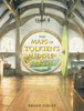
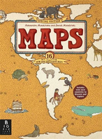
Maps Special Edition

Explore the world with this lavish new edition of the bestselling Maps. Released to mark the 10th anniversary of the very first edition, this book features 16 brand new maps and has new material on every page. Each highly illustrated map details not only geographical features and political borders but also places of interest, iconic personalities, native animals and plants, local peoples, cultural events, and many more fascinating facts assorted with each region. It`s a celebration of the world, from its immense mountains to its tiny insects - and everything in between!
RIP - This product is no longer available on our network. It was last seen on 25.09.2019

This page now acts as a permanent archive for this product. Add more information using the comments box below to ensure it can still be found by future generations.

Use our search facility to see if it is available from an alternative contributor.
  • Availability: Out Of Stock
  • Supplier: Stanfords
  • SKU: 9781783708048
Availability: In Stock
£25.00

Product Description

Explore the world with this lavish new edition of the bestselling Maps. Released to mark the 10th anniversary of the very first edition, this book features 16 brand new maps & has new material on every page. Each highly illustrated map details not only geographical features & political borders but also places of interest, iconic personalities, native animals & plants, local peoples, cultural events, & many more fascinating facts assorted with each region. It`s a celebration of the world, from its immense mountains to its tiny insects
- & everything in between!

Reviews/Comments

Add New

Intelligent Comparison

Oooops!
We couldn't find anything!
Perhaps this product's unique.... Or perhaps we are still looking for comparisons!
Click to bump this page and we'll hurry up.

Price History

Vouchers

No voucher codes found.
Do you know a voucher code for this product or supplier? Add it to Insights for others to use.

Facebook

Jargon Buster

World - A physical grouping, commonly used to describe earth and everything associated with ti
Borders - A line that sometimes can be built up separating off an area, e.g. countries "the welsh boarder"

Supplier Information

Stanfords
Stanfords was established in 1853 and opened their iconic Covent Garden flagship store in 1901. They have become the top retailer of maps, travel books and accessories in the UK and arguably offer the largest selection of maps and travel books worldwide. Famous names such as Captain Robert Falcon Scott, Ranulph Fiennes and Michael Palin have purchased from Stanfords. They now have a shop in Bristol and both stores together with other venues operate a calendar of events including talks, book signings and exhibitions. As a specialist map retailer, the map selection is comprehensive and includes road maps, street maps and walking maps from worldwide destinations, as well as a selection of world atlases and wall maps. Books include travel guides and travel literature. Stanfords also stock globes, from miniatures made of blue marble to magnificent floor-standing globes. The website features a selection of interesting articles on travel topics.
Page Updated: 2023-11-12 20:15:36

Community Generated Product Tags

Oh No! The productWIKI community hasn't generated any tags for this product yet!
Menu