
 United Kingdom
 France
 Germany
 Netherlands
 Sweden
 USA
USA
 Italy
Italy
 Spain
Spain
More From Contributor

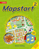

Mapstart 1 Pupil Book
This structured map skills course uses a simple colourful layout to introduce young pupils to using and drawing maps and plans. Mapstart 1 is a structured introduction to map work for 6-7 year olds. It assumes no previous experience of map skills and establishes a sound foundation for graphic concepts, skills and vocabulary at a very simple level. Mapstart 1 has been designed with the following purposes in mind: * to build children`s spatial awareness through the use of familiar objects, toys, the locality of the school and space photos; * to extend children`s understanding and use of vocabulary associated with spatial location, organisation and movement; * to provide continuity through the book by the use of vertical aerial photos; * to introduce children to the perspective of plans
and maps and to the representational characteristics of maps; * to encourage children to observe features and relationships in oblique and vertical photos and maps; * to foster children`s appreciation of the Earth as a globe. A free file of answers to questions in Mapstart 1 is available free to download at www.collinseducation.com/resources/mapstart1answers.pdf
and maps and to the representational characteristics of maps; * to encourage children to observe features and relationships in oblique and vertical photos and maps; * to foster children`s appreciation of the Earth as a globe. A free file of answers to questions in Mapstart 1 is available free to download at www.collinseducation.com/resources/mapstart1answers.pdf

Product Description
Reviews/Comments
Add New
Vouchers
No voucher codes found.
Do you know a voucher code for this product or supplier? Add it to Insights for others to use.
Do you know a voucher code for this product or supplier? Add it to Insights for others to use.
 Denmark