
 United Kingdom
 France
 Germany
 Netherlands
 Sweden
 USA
USA
 Italy
Italy
 Spain
Spain
More From Contributor

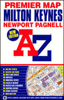
Milton Keynes Premier A-Z Map
Milton Keynes Premier Street Plan, including Newport Pagnell and Bletchley, at 1:16.890 (3.75” to 1 mile) from Geographers` A-Z Map Company with an index listing streets, places and areas, hospitals, industrial estates, selected flats and walkways, stations and selected places of interest, shown where appropriate with their postcodes. Current edition of this title was published in 2012.A and B roads are highlighted and shown with junction names; the plan also indicates the V and H road numbers. One way traffic, restricted access, pedestrianized streets, selected car parks and Park & Ride facilities are marked. Railway stations are shown with names. Also marked are selected cycleways. Colouring and/or symbols indicate public building, services and facilities, including
shopping centres or market streets, industrial buildings, hospitals or healthcare, etc. Public toilets are marked, indicating those with facilities for the disabled. The map also shows local authority and postcode boundaries, plus national grid lines. The index is next to the map.Also provided is a simplified road map of the city with just A, B, H and V roads plus selected connecting streets.
shopping centres or market streets, industrial buildings, hospitals or healthcare, etc. Public toilets are marked, indicating those with facilities for the disabled. The map also shows local authority and postcode boundaries, plus national grid lines. The index is next to the map.Also provided is a simplified road map of the city with just A, B, H and V roads plus selected connecting streets.

Product Description
Reviews/Comments
Add New
Vouchers
No voucher codes found.
Do you know a voucher code for this product or supplier? Add it to Insights for others to use.
Do you know a voucher code for this product or supplier? Add it to Insights for others to use.
 Denmark