
 United Kingdom
 France
 Germany
 Netherlands
 Sweden
 USA
USA
 Italy
Italy
 Spain
Spain
More From Contributor

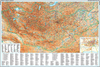
Mongolia ITMB
Mongolia on a double-sided, indexed map at 1:1, 785, 000 from ITMB with altitude colouring to show the country’s topography, plus a large street plan of central Ulaanbaatar annotated with hotels and places of interest. All place names are shown transliterated.The map divides the country east/west with a very generous overlap between the sides. Topography is shown by bold altitude colouring with graphics for swamps, glaciers, sand dunes, water wells, etc. National parks and protected areas are highlighted. Road network indicates partially paved and unpaved roads, includes selected tracks and shows locations of border crossings from Russia or China and petrol stations. Driving distances are shown on main and many local routes. Railway lines are included and domestic airports are
marked. The map also shows internal administrative boundaries with names of the provinces and highlights various places of interest. Latitude and longitude lines are drawn at 2° intervals and each side has a separate index. A large, clear street plan shows the town centre of Ulaanbaatar, highlighting several hotels, foreign embassies, and various places of interest. Also provided is an inset showing the county`s natural zones (taiga, steppe, desert, etc).
marked. The map also shows internal administrative boundaries with names of the provinces and highlights various places of interest. Latitude and longitude lines are drawn at 2° intervals and each side has a separate index. A large, clear street plan shows the town centre of Ulaanbaatar, highlighting several hotels, foreign embassies, and various places of interest. Also provided is an inset showing the county`s natural zones (taiga, steppe, desert, etc).

Product Description
Reviews/Comments
Add New
Vouchers
No voucher codes found.
Do you know a voucher code for this product or supplier? Add it to Insights for others to use.
Do you know a voucher code for this product or supplier? Add it to Insights for others to use.
 Denmark