
 United Kingdom
 France
 Germany
 Netherlands
 Sweden
 USA
USA
 Italy
Italy
 Spain
Spain
More From Contributor

Mongolia Reise Know-How
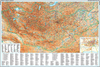
Indexed, waterproof and tear-resistant road map of Mongolia at 1:1, 600, 000 with topographic and tourist information, published by Reise Know-How as part of their highly acclaimed World Mapping Project. The map is double-sided to provide the best balance between a good scale and a convenient size sheet; a very generous overlap means that Ulaan-Baatar is included on both sides. Names of many towns are given with alternative versions, whilst larger towns are also the Cyrillic alphabet.The country’s topography is presented by light altitude colouring with spot heights, mountain passes, and names of mountain ranges. The map also shows caves, oases and seasonal rivers and lakes. Internal administrative boundaries are shown with names of the provinces. Road network includes unsurfaced
local roads and tracks, gives driving distances on main and secondary roads, and shows border crossings. The course of the Trans-Mongolian Railway is clearly marked and local airfields are indicated. Symbols highlight various places of interest, including national parks and protected areas, UNESCO world heritage sites, Buddhist monasteries, rock paintings, etc. The map has a latitude and longitude grid at intervals of 1°. The index of localities includes a separate list of national parks and reserves. Map legend includes English.
local roads and tracks, gives driving distances on main and secondary roads, and shows border crossings. The course of the Trans-Mongolian Railway is clearly marked and local airfields are indicated. Symbols highlight various places of interest, including national parks and protected areas, UNESCO world heritage sites, Buddhist monasteries, rock paintings, etc. The map has a latitude and longitude grid at intervals of 1°. The index of localities includes a separate list of national parks and reserves. Map legend includes English.
Product Description
Reviews/Comments
Add New
Vouchers
No voucher codes found.
Do you know a voucher code for this product or supplier? Add it to Insights for others to use.
Do you know a voucher code for this product or supplier? Add it to Insights for others to use.
 Denmark