
 United Kingdom
 France
 Germany
 Netherlands
 Sweden
 USA
USA
 Italy
Italy
 Spain
Spain
More From Contributor


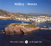

Naxos
Naxos on a map from Kompass, with a simple plan of Naxos Town and tourist overprint highlighting places of interest and some hiking trails. Contours at 40m intervals and colouring to indicate various types of vegetation show the topography and land use. The overprint shows a few hiking routes and highlights various places of interest and tourist facilities, including campsites and youth hostels, sport and recreational facilities, beaches, surfing and diving sites, etc. All place names are in both Greek and Latin alphabet. The map has a UTM grid. Map legend includes English.Also provided is a simple plan of Naxos Town with a list of selected accommodation, cafes and discos, plus a map of ferry connections across the Aegean.
Product Description
Reviews/Comments
Add New
Intelligent Comparison
Archived Product
Naxos Stanfords
£7.50
Archived Product

Naxos Stanfords
£14.95
Archived Product
Paxos Stanfords
£7.99
Archived Product

Nas Stanfords
£16.99
Vouchers
No voucher codes found.
Do you know a voucher code for this product or supplier? Add it to Insights for others to use.
Do you know a voucher code for this product or supplier? Add it to Insights for others to use.
 Denmark