More From Contributor

£3.50
Nenthead in 1898 in a fascinating series of reproductions of old Ordnance Survey plans in the Alan Godfrey Editions, ideal for anyone interested in the history of their neighbourhood or family. The map is double-sided & covers the village of Nenthead which in the 19th century grew into a mining town of over 2, 000 people, developed by the Quaker London Lead Company, & with pensions, education & health resources that foreshadowed the Welfare State. By the time of this map it was in rapid decline, & during the 20th century its population sank to around 350. The main map covers the northern part of the village, including Whitehall, Holmsfoot, Wellgill Dykehead, Brownleyhill Dressingfloor, Greenends, Foulard, & stretching east to Haggs Mine & Nentsberry. On the reverse is a large section of the adjacent sheet 42.03 which covers the village centre & the Rampgill Mine, part of which forms today`s Nenthead Mines Heritage Centre. About the Alan Godfrey Editions of the 25” OS Series: Selected towns in Great Britain & Ireland are covered by maps showing the extent of urban development in the last decades of the 19th & early 20th century. The plans have been taken from the Ordnance Survey mapping & reprinted at about 15 inches to one mile (1:4, 340). On the reverse most maps have historical notes & many also include extracts from contemporary directories. Most maps cover about one mile (1.6kms) north/south, one & a half miles (2.4kms) across; adjoining sheets can be combined to provide wider coverage.FOR MORE INFORMATION & A COMPLETE LIST OF ALL AVAILABLE TITLES PLEASE CLICK ON THE SERIES LINK. ...
Archived Product
£195.00
The Neon Classic Illuminated Globe by National Geographic measures 30 cm (12”) diameter & features clear political mapping, a ring maple base & an aluminium stem. This is a stylish globe suitable for children as well as adults. The plexyglass ball features political mapping from the renowned National Geographic, clearly conveying up to date information of the world (over 2, 000 place names). The countries are distinguished by different colour borders & the topography is represented by relief shading & main mountain ranges are named. Shades of blue differentiate the seas & oceans depth, warm currents are also shown. Its sturdy construction, the solid maple ring base & the aluminium stem, make this a perfect globe for regular use, & when switched on, it transforms into a warm light night lamp. The Neon Classic Illuminated combines the latest information with a modern look & it is a fantastic addition to family & children’s rooms. This globe is also available as a non illuminated model. ...
Archived Product
£195.00
The illuminated Neon Executive Globe by National Geographic is a 30 cm (12”) stylish globe. With its political antique style mapping, solid oak base & a brass stem, it adds an elegant touch to any room. The plexyglass ball features political mapping from the renowned National Geographic clearly conveying up to date information of the world (over 2, 000 place names). The countries are distinguished by different understated colouring & the topography is defined by relief shading & main mountain ranges are named. In particular, the ocean floor boasts impressive details showing relief shading, continental shelf & ridges. The modern design of the solid oak base & the turned brass stem complement the classic ball creating a distinguished & stylish look. This is a beautiful globe offering the latest information & it is sure to enrich both modern & traditional settings. ...
Archived Product
£11.99
Everyone knows that chameleons are the best at fitting in. But not Leon. Leon is neon! In fact, he`s SO bright that he keeps all the other chameleons awake at night. But poor Leon is lonely, so he goes off in search of somewhere he can blend in. In this delightful interactive book, filled with vibrant neon artwork, children can help Leon on his journey by counting his steps, sending him to sleep & giving him lots of reassurance when he`s feeling down. But will he ever find a place he can fit in...? ...
Archived Product
£6.99
Everyone knows that chameleons are the best at fitting in. But not Leon. Leon is neon! In fact, he`s SO bright that he keeps all the other chameleons awake at night. But poor Leon is lonely, so he goes off in search of somewhere he can blend in. In this delightful interactive book, filled with vibrant neon artwork, children can help Leon on his journey by counting his steps, sending him to sleep & giving him lots of reassurance when he`s feeling down. But will he ever find a place he can fit in...?” Joyously written & illustrated”
- New Statesman
...
Archived Product
£12.99
Topographic survey of France at 1:25, 000 in IGN`s excellent TOP25 / Série Bleue series. All the maps are GPS compatible, with a 1km UTM grid plus latitude & longitude lines at 5’ intervals. Contours are at 5m intervals except for mountainous areas where the maps have contours at 10m intervals, vividly enhanced by hill shading & graphics for rocky terrain. Colouring with graphics indicates different types of vegetation or land use (deciduous or coniferous forests, moors, orchards, vineyards, etc). PLEASE NOTE: coverage of France at this scale is currently being revised – the format & the presentation of each title are indicated by the letters at the end of its Sheet Reference number (e.g. 0416ET, 3531ETR, 1923SB, etc.)MAPS WITH FULL TOURIST OVERPRINT & AN ENGLISH MAP LEGEND: all TOP25 maps & the SB editions of Série Bleue have an overprint highlighting waymarked walking trails including long-distance GR routes &, where appropriate, ski routes. Symbols indicate campsites, gîtes d’etape, refuges, equestrian centres & other recreational facilities or sites, tourist information centres, cultural heritage, etc. Towns & locations of particular interest are highlighted.- ET or OT = single-sided TOP25 map covering approx. 29x 21 km / 18x 13 miles.- ETR or OTR = waterproof & tear resistant TOP25 map covering the same area as the corresponding ET or OT number, but double-sided, printed on a smaller size sheet with a good overlap between the sides.- SB = Série Bleue map with full tourist overprint; these maps, first introduced in summer 2014, each cover approx. 29x 24km / 18x 15 miles.SÉRIE BLEUE maps with numbers ending in E (Est) or O (Ouest): most editions now indicate the GR routes, but do not show any other tourist information. Map legend is in French only. Each map covers approx. 14x 20km / 9x 12 miles. ...
Archived Product
£18.99
Topographic survey of France at 1:25, 000 in IGN`s excellent TOP25 / Série Bleue series. All the maps are GPS compatible, with a 1km UTM grid plus latitude & longitude lines at 5’ intervals. Contours are at 5m intervals except for mountainous areas where the maps have contours at 10m intervals, vividly enhanced by hill shading & graphics for rocky terrain. Colouring with graphics indicates different types of vegetation or land use (deciduous or coniferous forests, moors, orchards, vineyards, etc). PLEASE NOTE: coverage of France at this scale is currently being revised – the format & the presentation of each title are indicated by the letters at the end of its Sheet Reference number (e.g. 0416ET, 3531ETR, 1923SB, etc.)MAPS WITH FULL TOURIST OVERPRINT & AN ENGLISH MAP LEGEND: all TOP25 maps & the SB editions of Série Bleue have an overprint highlighting waymarked walking trails including long-distance GR routes &, where appropriate, ski routes. Symbols indicate campsites, gîtes d’etape, refuges, equestrian centres & other recreational facilities or sites, tourist information centres, cultural heritage, etc. Towns & locations of particular interest are highlighted.- ET or OT = single-sided TOP25 map covering approx. 29x 21 km / 18x 13 miles.- ETR or OTR = waterproof & tear resistant TOP25 map covering the same area as the corresponding ET or OT number, but double-sided, printed on a smaller size sheet with a good overlap between the sides.- SB = Série Bleue map with full tourist overprint; these maps, first introduced in summer 2014, each cover approx. 29x 24km / 18x 15 miles.SÉRIE BLEUE maps with numbers ending in E (Est) or O (Ouest): most editions now indicate the GR routes, but do not show any other tourist information. Map legend is in French only. Each map covers approx. 14x 20km / 9x 12 miles. ...
Archived Product
£9.95
Nepal road map with bold relief shading & spot heights for numerous peaks. Road network indicates driving distances on principal highways & main roads. Trail connections in more remote areas & locations of local airfields are also shown. Internal divisions into zones & districts are prominently indicated with names of administrative units. The map shows boundaries of national parks & protected areas & highlights various places of interest, including names & heights of numerous peaks. Latitude & longitude grid is at intervals of 30 ...
Archived Product
£11.95
Nepal at 1:750, 000 on an indexed map from Mair Dumont with a set of removable stickers to highlight chosen locations. A fold-out flap in the jacket makes route planning easier by providing an overview of the whole area covered by the map plus the adjoining regions & highlighting popular locations, with its grid reference system in the margins making it easier to find places on the main map. A set of seven peel-on/peel-off stickers, removable from the map without damaging its surface, is provided for making selected locations more prominent when navigating. Topography is shown by bold relief shading with spot heights & mountain passes. Many peaks are named & those best known highlighted, as are Nepal ...
Archived Product
£9.50
Nepal on an indexed, waterproof & tear-resistant road map, ideal for locating the country's numerous famous peaks, with topographic & tourist information, & enlargements for Kathmandu, Pokhara, & Chitwan regions, plus Bhaktapur. The map, published by Reise Know-How as part of their highly acclaimed World Mapping Project, is double-sided to provide the best balance between a good scale & a convenient size sheet. The base map has altitude colouring with contours, spot heights & mountain passes. Names of main trekking areas are prominently highlighted in coloured boxes (e.g. Khumbu Himal, Mustang, Dolpa, etc.), as are names of national parks & conservation areas. The same system is used for numeous peaks
- colour coding to indicate famous peaks (Everest, Annapurna, Kanchenjunga, Dhaulagiri, etc.), peaks requiring permit & fee payment (Island Peak, Mera, Peak, Naya Kanga, etc.) & permit & royalty free peaks. Classic trekking routes are marked, e.g. Jiri to Everest Base Camp, the Annapurna Circuit, etc. The map highlights rafting or kayaking rivers such as Dudh & Tamba Kosi, Kali Gandaki, etc. Areas suitable for mountain biking are also indicated. Internal administrative boundaries are shown with names of the provinces. Road network

Includes::
local roads, highlights scenic routes & indicates locations of fuel supply stations. Local airfields & helipads are also marked. A wide range of symbols highlights various places of interest, including temples & monasteries of various religions, archaeological sites, viewpoints, Tharu villages, crocodile & elephant breeding centres, etc. The map has a latitude & longitude grid at intervals of 15


...
Archived Product

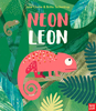
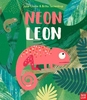
Neon Nature Colouring And Sticker Activity Book

Part of a groundbreaking activity book series, this book brings together stylish design, fluorescent stickers and lots and lots of facts about nature. Non-fiction about animals under the sea has never looked so good! The creative and educational colouring activities are brought to life by fluorescent stickers.
RIP - This product is no longer available on our network. It was last seen on 25.09.2019

This page now acts as a permanent archive for this product. Add more information using the comments box below to ensure it can still be found by future generations.

Use our search facility to see if it is available from an alternative contributor.
  • Availability: Out Of Stock
  • Supplier: Stanfords
  • SKU: 9781909767638
Availability: In Stock
£5.99

Product Description

Part of a groundbreaking activity book series, this book brings together stylish design, fluorescent stickers & lots & lots of facts about nature. Non-fiction about animals under the sea has never looked so good! The creative & educational colouring activities are brought to life by fluorescent stickers.

Reviews/Comments

Add New

Intelligent Comparison

Oooops!
We couldn't find anything!
Perhaps this product's unique.... Or perhaps we are still looking for comparisons!
Click to bump this page and we'll hurry up.

Price History

Vouchers

No voucher codes found.
Do you know a voucher code for this product or supplier? Add it to Insights for others to use.

Facebook

Jargon Buster

Stylish - A desirable design or layout
Sticker - A label that has an adhesive glue on the back and generally pictures on the front.
Design - A drawing or styles that shows the look and functionality of something before its made.

Supplier Information

Stanfords
Stanfords was established in 1853 and opened their iconic Covent Garden flagship store in 1901. They have become the top retailer of maps, travel books and accessories in the UK and arguably offer the largest selection of maps and travel books worldwide. Famous names such as Captain Robert Falcon Scott, Ranulph Fiennes and Michael Palin have purchased from Stanfords. They now have a shop in Bristol and both stores together with other venues operate a calendar of events including talks, book signings and exhibitions. As a specialist map retailer, the map selection is comprehensive and includes road maps, street maps and walking maps from worldwide destinations, as well as a selection of world atlases and wall maps. Books include travel guides and travel literature. Stanfords also stock globes, from miniatures made of blue marble to magnificent floor-standing globes. The website features a selection of interesting articles on travel topics.
Page Updated: 2023-11-12 20:15:36

Community Generated Product Tags

Oh No! The productWIKI community hasn't generated any tags for this product yet!
Menu