More From Contributor
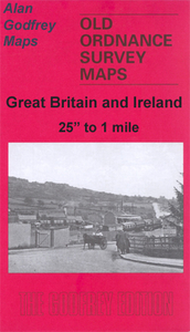
£12.99
Map No. 1114, Nesslau, in the topographic survey of Switzerland at 1:25, 000 from Bundesamt für Landestopographie (swisstopo), covering the whole country on 247 small format sheets, with special larger maps published for popular regions including some titles now available in hiking versions. Highly regarded for their superb use of graphic relief & hill shading, the maps give an almost 3-D picture of Switzerland`s mountainous terrain. Contours are at 10 m intervals, with 20m intervals in the mountainous areas. All the maps have a 1-km grid for Swiss national coordinates (datum CH 1903). * Small format sheets (Nos. 1011
- 1374)* Map legend in the language of the area covered by the map. Additional margin ticks show latitude & longitude in steps of 2`. The area covered by each map is 17 x 12 km (11 x 7 miles approx). * Special larger sheets (Nos. from 2501 onwards) – STANDARD editions:* No map legend is included but a separate leaflet can be provided instead. The area covered by each map is 25 x 17 km (15 x 11 miles approx).* Special larger sheets (Nos. from 2501 onwards) – HIKING editions:* An overprint highlights hiking, mountain & alpine paths, including regional & national long-distance trails. The maps also show bus routes with bus stops, plus inns in remote locations. The area covered by each map is 25 x 17 km (15 x 11 miles approx).
...
Archived Product
£7.99
Contained inside a nestlined box, these colourful, speckled stickies make a delightful gift to a friend or a memorable way to deliver a sweet note. The set

Includes::
three sticky note pads, sixty sheets each
- that`s fifteen dozen eggs! Nested Notes are a perfect companion to the Nests & Eggs Notecards, Bird Watching & Other Nature Observations Journal, & our bestselling tome Americas Other Audubon.


...
Archived Product
£2.95
Stockport Offerton & Foggbrook in 1907 in a fascinating series of reproductions of old Ordnance Survey plans in the Alan Godfrey Editions, ideal for anyone interested in the history of their neighbourhood or family. Selected towns in Great Britain & Ireland are covered by maps showing the extent of urban development in the last decades of the 19th & early 20th century. In this title: the map covers an area south-eastern of Stockport that was still semi-rural. Coverage stretches from Maitland Street eastward to Foggbrook, & from Banks Lane southward to Cherrytree Lane. Features include Stockport Great Moor area, Offerton Fold, Mile End Hall, Hampstead Cotton Mills, Isolation Hospital, Hollymount Lodge, Dialstone Lane Farm, Girls Industrial School, Offerton Industrial School, Gildedhollies, St John's church, Offerton Hall, Foggbrook Print Works, etc. On the reverse is an 1896 directory of Offerton. About the Alan Godfrey Editions of the 25 ...
Archived Product
£3.50
Stockport Offerton & Foggbrook in 1907 in a fascinating series of reproductions of old Ordnance Survey plans in the Alan Godfrey Editions, ideal for anyone interested in the history of their neighbourhood or family. The map covers an area south-eastern of Stockport that was still semi-rural. Coverage stretches from Maitland Street eastward to Foggbrook, & from Banks Lane southward to Cherrytree Lane. Features include Stockport Great Moor area, Offerton Fold, Mile End Hall, Hampstead Cotton Mills, Isolation Hospital, Hollymount Lodge, Dialstone Lane Farm, Girls Industrial School, Offerton Industrial School, Gildedhollies, St John`s church, Offerton Hall, Foggbrook Print Works, etc. On the reverse is an 1896 directory of Offerton. About the Alan Godfrey Editions of the 25” OS Series: Selected towns in Great Britain & Ireland are covered by maps showing the extent of urban development in the last decades of the 19th & early 20th century. The plans have been taken from the Ordnance Survey mapping & reprinted at about 15 inches to one mile (1:4, 340). On the reverse most maps have historical notes & many also include extracts from contemporary directories. Most maps cover about one mile (1.6kms) north/south, one & a half miles (2.4kms) across; adjoining sheets can be combined to provide wider coverage.FOR MORE INFORMATION & A COMPLETE LIST OF ALL AVAILABLE TITLES PLEASE CLICK ON THE SERIES LINK. ...
Archived Product
£17.99
One of the titles in a series of maps from the Israeli Survey, in Hebrew
- with some Roman alphabet equivalents, providing coverage
...
Archived Product
£7.99
In early 2006, Chuck Ramkissoon is found dead at the bottom of a New York canal. In London, a Dutch banker named Hans van den Broek hears the news, & remembers his unlikely friendship with Chuck & the off-kilter New York in which it flourished: the New York of 9/11, the powercut & the Iraq war. Those years were difficult for Hans
- his English wife Rachel left with their son after the attack, as if that event revealed the cracks & silences in their marriage, & he spent two strange years in New York`s Chelsea Hotel, passing stranger evenings with the eccentric residents. Lost in a country he`d regarded as his new home, Hans sought comfort in a most alien place
- the thriving but almost invisible world of New York cricket, in which immigrants from Asia & the West Indies play a beautiful, mystifying game on the city`s most marginal parks. It was during these games that Hans befriends Chuck Ramkissoon, who dreamed of establishing the city`s first proper cricket field. Over the course of a summer, Hans grew to share Chuck`s dream & Chuck`s sense of American possibility
- until he began to glimpse the darker meaning of his new friend`s activities & ambitions.` Netherland` is a novel of belonging & not belonging, & the uneasy state in between. It is a novel of a marriage foundering & recuperating, & of the shallows & depths of male friendship. With it, Joseph O` Neill has taken the anxieties & uncertainties of our new century & fashioned a work of extraordinary beauty & brilliance.


...
Archived Product
£7.99
The network of signposted cycling routes in Netherlands & Flanders on large, double-sided indexed maps at 1:50, 000 from Falk, with prominent highlighting of the long-distance LF routes, symbols indicating accommodation & other tourist services, plus in each title two or more panels with recommended local circuits & additional tourist information. The series

Includes::
some adjoining areas in Lower Saxony, & has now been extended to cover Flanders. The extensive network of sign-posted cycling routes, including the LF long-distance cycle paths, consists of numbered junctions joined by sign-posted connecting routes in either direction. At each junction there is an information panel showing an overview map of the whole network with the junction numbers. A second panel shows all the intersections directly connected to that junction. The system enables cyclists to plan their own routes by preparing a list of junction numbers through which they want to travel. Falk maps give cycling distances between the junctions & indicate which roads, both within the numbered network & outside it, have separate cycling paths. Routes which are part of the LF network of long-distance cycle routes are clearly marked. A wide range of symbols shows various accommodation options, bars & restaurants, & various places of interest. Landscape information is provided by colouring for woodlands, dunes, etc. The maps are indexed & show in the margins latitude & longitude at 1`52” intervals. Map legend

Includes::
English. The maps also include recommendations of best tourist attractions from the VVV
- Dutch Tourist Board, & addresses of their local offices.COMPARISON BETWEEN THE FALK & THE ANWB 50K CYCLING MAPS OF THE NETHERLANDS:- Similar area per map, but Falk has larger sheets because of the additional panels with recommended local tours & other tourist information; ANWB maps are smaller & easier to handle.- Falk maps are indexed & have English legend, ANWB’s are not & the legend is in Dutch only.- Falk maps have clearer highlighting of the LF long-distance routes.- GPS: Falk maps give latitude & longitude, ANWB’s have coordinates of the Dutch National Grid.- Falk maps have more symbols indicating various types of accommodation & places of interest.


...
Archived Product
£5.99
Netherlands at 1:400, 000 from Michelin, with information on driving regulations, a distance & journey time table, plus enlargements showing in greater detail road access to Amsterdam, The Hague & Rotterdam with the Europoort & Hoek Van Holl&. Roads network

Includes::
local roads & is graded according to the number of lanes. Junctions show full or partial interchanges. Steep gradients (!), level crossings & restricted entry sections are marked; scenic routes are highlighted. Railway lines & ferry routes are included. Relief shading is used to indicate the topography, with colouring for forested areas. National parks are also marked. Small symbols indicate various landmarks or places of interest including campsites & youth hostels, but the map is not primarily designed to highlight tourist sights. The map also indicates locations with street plans in Michelin

...
Archived Product
£4.99
Netherlands at 1:300, 000 from Geo Center with cartography from Mair Dumont. Coverage extends to Brussels & Cologne. Street plans are provided for central Amsterdam, Rotterdam, The Hague, Brussels & Antwerp. Coverage extends south to beyond Brussels to include Antwerp, Bruges & Ghent, plus east to Cologne & the Ruhr. The map shows the country ...
Archived Product
£5.99
Netherlands at 1:300, 000 from Insight Guides, with street plans of central Amsterdam, Rotterdam & The Hague, plus enlargements showing access to these cities & Utrecht, all presented on one side of a very large sheet. The road map presents very clearly the country ...
Archived Product

Nether Edge 1903

Nether Edge in 1903 in a fascinating series of reproductions of old Ordnance Survey plans in the Alan Godfrey Editions, ideal for anyone interested in the history of their neighbourhood or family. The map covers the south-western area of Sheffield towards Carter Knowle. Coverage stretches from Valley Road westward to Hill Lane and Banners Cross Hall and from Ulverston Road northward to Chippinghouse Road. Features include railway with Heeley station, tramways, Norton Hammer, Heeley Mill, Cherry Tree Hill, Nether Edge, Brinkcliffe Tower, Ecclesall Bierlow Workhouse, St Andrew`s church (top of map), Brincliffe, Ruskin Museum, Meersbrook Park, St Peter`s church, Smithy Wood Bottom, etc. On the reverse are street directory entries for Abbeydale Road, Brincliffe Edge Road,
Carter Knowle Road, Nether Edge Road and Oak Hill Road.About the Alan Godfrey Editions of the 25” OS Series:Selected towns in Great Britain and Ireland are covered by maps showing the extent of urban development in the last decades of the 19th and early 20th century. The plans have been taken from the Ordnance Survey mapping and reprinted at about 15 inches to one mile (1:4, 340). On the reverse most maps have historical notes and many also include extracts from contemporary directories. Most maps cover about one mile (1.6kms) north/south, one and a half miles (2.4kms) across; adjoining sheets can be combined to provide wider coverage.FOR MORE INFORMATION AND A COMPLETE LIST OF ALL AVAILABLE TITLES PLEASE CLICK ON THE SERIES LINK.
RIP - This product is no longer available on our network. It was last seen on 25.09.2019

This page now acts as a permanent archive for this product. Add more information using the comments box below to ensure it can still be found by future generations.

Use our search facility to see if it is available from an alternative contributor.
  • External links may include paid for promotion
  • Availability: Out Of Stock
  • Supplier: Stanfords
  • SKU: 9780850542196
Availability: In Stock
£3.50

Product Description

Nether Edge in 1903 in a fascinating series of reproductions of old Ordnance Survey plans in the Alan Godfrey Editions, ideal for anyone interested in the history of their neighbourhood or family. The map covers the south-western area of Sheffield towards Carter Knowle. Coverage stretches from Valley Road westward to Hill Lane & Banners Cross Hall & from Ulverston Road northward to Chippinghouse Road. Features include railway with Heeley station, tramways, Norton Hammer, Heeley Mill, Cherry Tree Hill, Nether Edge, Brinkcliffe Tower, Ecclesall Bierlow Workhouse, St Andrew`s church (top of map), Brincliffe, Ruskin Museum, Meersbrook Park, St Peter`s church, Smithy Wood Bottom, etc. On the reverse are street directory entries for Abbeydale Road, Brincliffe Edge Road, Carter Knowle Road, Nether Edge Road & Oak Hill Road. About the Alan Godfrey Editions of the 25” OS Series: Selected towns in Great Britain & Ireland are covered by maps showing the extent of urban development in the last decades of the 19th & early 20th century. The plans have been taken from the Ordnance Survey mapping & reprinted at about 15 inches to one mile (1:4, 340). On the reverse most maps have historical notes & many also include extracts from contemporary directories. Most maps cover about one mile (1.6kms) north/south, one & a half miles (2.4kms) across; adjoining sheets can be combined to provide wider coverage.FOR MORE INFORMATION & A COMPLETE LIST OF ALL AVAILABLE TITLES PLEASE CLICK ON THE SERIES LINK.

Reviews/Comments

Add New

Intelligent Comparison

Oooops!
We couldn't find anything!
Perhaps this product's unique.... Or perhaps we are still looking for comparisons!
Click to bump this page and we'll hurry up.

Price History

Vouchers

No voucher codes found.
Do you know a voucher code for this product or supplier? Add it to Insights for others to use.

Facebook

Jargon Buster

Contemporary - Modern era design
Contemporary - A design reference to indicate post war modern design
History - Anything that happens in the past. An acedemic subject.
Hammer - A tool used for providing impact to an object such as a nail
Wood - A hard material found in trees. Used for tool making, fuel and construction.
edge - Enhanced data rates for GSM evolution also known as enhanced GPRS. A mobile phone technology with improved data transmission rates.
edge - The point at which two surfaces meet
Road - a manmade lane or a path that is used to speed up travel.
Contemporary - An object that is living in the same time.
Mill - A building which can grind grain into flour.
Hall - A room at the inside of an entrance of a house.
Museum - A building which exhibits old artefacts for viewing of people who show interest.
Oak - A member of the beech tree family that has acorns growing on it.
Ideal - Something that satisfies a perfect criteria.
Family - A group of people that live together made up from parents and children.

Supplier Information

Stanfords
Stanfords was established in 1853 and opened their iconic Covent Garden flagship store in 1901. They have become the top retailer of maps, travel books and accessories in the UK and arguably offer the largest selection of maps and travel books worldwide. Famous names such as Captain Robert Falcon Scott, Ranulph Fiennes and Michael Palin have purchased from Stanfords. They now have a shop in Bristol and both stores together with other venues operate a calendar of events including talks, book signings and exhibitions. As a specialist map retailer, the map selection is comprehensive and includes road maps, street maps and walking maps from worldwide destinations, as well as a selection of world atlases and wall maps. Books include travel guides and travel literature. Stanfords also stock globes, from miniatures made of blue marble to magnificent floor-standing globes. The website features a selection of interesting articles on travel topics.
Page Updated: 2023-11-12 20:15:36

Community Generated Product Tags

Oh No! The productWIKI community hasn't generated any tags for this product yet!
Menu