More From Contributor
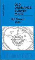
£3.50
Old Portsmouth & Gosport in 1896 in a fascinating series of reproductions of old Ordnance Survey plans in the Alan Godfrey Editions, ideal for anyone interested in the history of their neighbourhood or family. Portsmouth is covered by a block of six maps. This map covers part of Old Portsmouth & parts of Gosport on the other side of the Harbour. Coverage stretches from Alexandra Road westward to Willis Road & Henry Street, & from Gosport High Street southward to Clarence Pier. Features include Haslar Royal Naval Hospital, Haslar Lake, Haslar Bridge, Horse Field, Holy Trinity church, High Street on Gosport side. The Point, Inner & Outer Camber, Victoria Pier, Garrison Chapel, Clarence Barracks, Clarence Pier, Cambridge Barracks, Government House, tramways, Colewort Barracks, St Thomas church on the Portsmouth side. Note that some sites are left blank for security reasons. On the reverse are street directory entries for Broad Street, Gosport High Street & St Thomas`s Street. About the Alan Godfrey Editions of the 25” OS Series Selected towns in Great Britain & Ireland are covered by maps showing the extent of urban development in the last decades of the 19th & early 20th century. The plans have been taken from the Ordnance Survey mapping & reprinted at about 15 inches to one mile (1:4, 340). On the reverse most maps have historical notes & many also include extracts from contemporary directories. Most maps cover about one mile (1.6kms) north/south, one & a half miles (2.4kms) across; adjoining sheets can be combined to provide wider coverage.FOR MORE INFORMATION & A COMPLETE LIST OF ALL AVAILABLE TITLES PLEASE CLICK ON THE SERIES LINK. ...
Archived Product
£12.99
Journeying through Southern France in the first years of the 20th century, Theodore Andrea Cook discovers a landscape where the presence of Phoenicians, Greeks & Romans is still evident in the Mediterranean`s surviving architecture. In Arles, Nimes, Orange & Frejus, he witnesses the wonders of Roman arenas, temples & monuments. At the imposing aqueduct of the Pont du Gard he sees the genius of Roman engineering. Cook`s survey of Provencal history also encompasses the Middle Ages, when religious conflict & bloody warfare scarred the region. At Les Baux he explores the ruins of a once-great stronghold; in Avignon he traces the footsteps of 14th-century popes in their palace; in Beaucaire & Tarascon he visits the sites of thriving medieval market towns & royal castles. First published in 1905, this is an insight not only into the area`s history & architecture, but also its literary & cultural significance. Looking at the work & influence of writers such as Petrarch & Mistral, Cook reveals the importance of language, romance & regional identity in Provence. ...
Archived Product
£12.00
In recent years, tourists have discovered the rustic charms of Puglia, also known as Apulia, the heel stretching down from the spur of the Italian boot. The region boasts beautiful landscapes & miles of dramatic coastline, cities with Romanesque cathedrals, Gothic castles, & a tremendous wealth of Baroque architecture, as well as rupestrian churches containing Byzantine frescoes. Yet until this book, almost nothing about the region had been published in English since the days of Norman Douglas & the Sitwells. Filling that gap, ” Old Puglia” is an entertaining exploration of the area & its historical influences, cultural sites, & emerging popularity. Now fashionable as the new Tuscany, Puglia is featured on radio & television; travel supplements describe its beaches & cooking; & supermarkets worldwide stock Apulian wine, olive oil, bread, & pasta. Desmond Seward & Susan Mountgarret introduce readers to the story behind the destination, as they combine in-depth writing on Puglian history with discussions of the area s contemporary culture. A fascinating look at a region whose ancient roots continue to delight modern enthusiasts, ” Old Puglia” will entertain travelers, history buffs, & everyone with a taste for Italy.” ...
Archived Product
£12.99
Apulia (or Puglia) is the heel of Italy, stretching down from the spur of the Italian boot. Its landscape is often very beautiful & it has wonderful old cities with Romanesque cathedrals, Gothic castles & a great wealth of Baroque architecture, together with rupestrian' churches that contain Byzantine frescoes. But, although far from inaccessible, until quite recently it was seldom visited by Anglo Saxons. Today, however, Apulia is becoming fashionable, an alternative to Tuscany. It is featured on radio & television; travel supplements describe its beaches & its cooking, supermarkets stock Apulian wine, oil, bread & pasta. Yet almost nothing about the region has been published in English since the days of Norman Douglas & the Sitwells. One can find holiday histories of Tuscany, but there is no popular introduction to Apulian history, not even in Italian. Our book, which grew out of what was originally intended as a travel book, has been written to fill the gap by providing a simple, readable account. ...
Archived Product
£2.95
Old Sarum in 1900 in a fascinating series of reproductions of old Ordnance Survey plans in the Alan Godfrey Editions, ideal for anyone interested in the history of their neighbourhood or family. Selected towns in Great Britain & Ireland are covered by maps showing the extent of urban development in the last decades of the 19th & early 20th century. In this title: this detailed map covers the historic Old Sarum, the Roman Sorbiodunum, including the site of old cathedral. To the west is the village of Stratford sub Castle, including St Lawrence's church, Manor House, Parsonage Farm, site of Parliament Tree. To the east is Castle Hill, with Old Sarum Farm. On the reverse is an extract from the First Edition six-inch map of 1887-9, showing the area at an earlier stage About the Alan Godfrey Editions of the 25 ...
Archived Product
£12.99
Get ready, book 10 in the phenomenally bestselling Diary of a Wimpy Kid series is coming! Life was better in the old days. Or was it? That`s the question Greg Heffley is asking as his town voluntarily unplugs & goes electronics-free. But modern life has its conveniences, & Greg isn`t cut out for an old-fashioned world. With tension building inside & outside the Heffley home, will Greg find a way to survive? Or is going `old school` just too hard for a kid like Greg? Praise for Jeff Kinney: ” The world has gone crazy for Jeff Kinney`s Diary of a Wimpy Kid.” (Sun). ” Kinney is right up there with J K Rowling as one of the bestselling children`s authors on the planet.” (Independent). ” The most hotly anticipated children`s book of the year is here
- Diary of a Wimpy Kid.” (Big Issue).
...
Archived Product
£6.99
Book 10 in the phenomenally bestselling Diary of a Wimpy Kid series is here! Life was better in the old days. Or was it? That`s the question Greg Heffley is asking as his town voluntarily unplugs & goes electronics-free. But modern life has its conveniences, & Greg isn`t cut out for an old-fashioned world. With tension building inside & outside the Heffley home, will Greg find a way to survive? Or is going `old school` just too hard for a kid like Greg? Praise for Jeff Kinney:` The world has gone crazy for Jeff Kinney`s Diary of a Wimpy Kid`
- Sun` Kinney is right up there with J K Rowling as one of the bestselling children`s authors on the planet` -Independent` The most hotly anticipated children`s book of the year is here
- Diary of a Wimpy Kid`
- Big Issue


...
Archived Product
£12.00
Old Series to Explorer is Chris Higley`s comprehensive guide to the history of the Ordnance Survey map & is a must for anyone with an interest in the evolution & development of the famous Ordnance Survey series of maps. The book gives a brief overview of the map series published by the Ordnance Survey in the last 200 years, as well as exploring other subjects closely related to Ordnance Survey. Individual chapters cover how the maps were made, one-inch maps of Engl&, Wales & Scotl&, 1:50, 000 maps of Great Britain, half-inch & smaller scale maps, 1:25, 000 maps, six-inch & larger scale maps, Ireland & the Crown Dependencies, How accurate a picture?, mapmakers at war & a collected bibliography. Details of where to look for more information & other relevant resources are highlighted at the end of each chapter in the book. ...
Archived Product
£3.50
Old St Pancras area of London in 1871-1894 in a series of exceptionally detailed reproductions of old Ordnance Survey street plans for areas of larger cities which have undergone substantial redevelopment in the late 19th or the early 20th century, published in the Alan Godfrey Editions. The plans, printed in back & white, have been taken from the original Ordnance Survey mapping at 1:1, 056 & reproduced at 1:1, 760 – the equivalent of 36 inches (or one yard) to a mile. The maps provide an unrivalled, house-by-house picture of streets & individual buildings with inner courtyards, outbuildings, pavements, covered passages, etc. Many important institutions are named; within the National Galley on Trafalgar Square even the individual rooms (the map is from 1871, so no French Impressionists as yet!). On the reverse are historical notes about the area covered by the map, plus extracts from contemporary street directories. These maps provide a fascinating addition to Alan Godfrey’s huge series of some 2, 000 titles presenting reproductions of street plans at taken from the Ordnance Survey mapping at 1:2, 500 (25” to 1 mile) & reprinted at about 15 inches to one mile (1:4, 340). ...
Archived Product
£22.99
The Old Strynefjellsvegen National Tourist Route Map belongs to a series of 18 map & postcards sets describing popular tourist routes all over Norway. The map set

Includes::
a map in 1: 50, 000 presenting an accurate topography (based on the Norwegian topographic survey) which describes local footpaths, cycle or ski routes, sport & recreational facilities, places of interest, places to stay & eat, viewpoints. The Old Strynefjell Mountain Road (Gamle Strynefjellsveien) is a 27-kilometre long stretch of road between Videseter in the municipality of Stryn & Grotli in the municipality of Skjåk. The Old Strynefjell Mountain Road, now a national tourist route, is a piece of cultural heritage more than 100 years old. Between the mountain village of Skjåk & the fjord village of Stryn there were several ancient routes used for the transport of people & essential goods. In 1881, the decision to build a road between Grotli & Hjelle was made. In 1894 the road was ready for use, a masterpiece of road-building & engineering. The stretch represents a piece of Norwegian natural history as the only way of passage between Skjåk & Stryn during most of the last century. This is the reason why the Old Strynefjell Mountain Road has been awarded the status as a national tourist route. Today, the old road is replaced with a new 12-kilometre long all-year road. However, it is still the old road that provides a view & perspective. Nature displays its contrasts along this stretch of road, with the rounded, glacier-scoured forms to the east & a steeper, more precipitous topography to the west. At Tystigen it is still possible to ski far into the summer. Otherwise, high summer & autumn is the time for walking in the mountains. The road is also excellent for cycling. The road is closed during winter & opens in June, depending on the amount of snow in the mountains. The set
Features: One map: scale 1:50, 000 Text in three languages (Norwegian, English & German)5 Postcards (13.5x 25cm) To see the list of other titles in this series, please click on the series link.


...
Archived Product

Old Sarum 1900

Old Sarum in 1900 in a fascinating series of reproductions of old Ordnance Survey plans in the Alan Godfrey Editions, ideal for anyone interested in the history of their neighbourhood or family. The map covers the historic Old Sarum, the Roman Sorbiodunum, including the site of old cathedral. To the west is the village of Stratford sub Castle, including St Lawrence`s church, Manor House, Parsonage Farm, site of Parliament Tree. To the east is Castle Hill, with Old Sarum Farm. On the reverse is an extract from the First Edition six-inch map of 1887-9, showing the area at an earlier stageAbout the Alan Godfrey Editions of the 25” OS SeriesSelected towns in Great Britain and Ireland are covered by maps showing the extent of urban development in the last decades of the 19th and
early 20th century. The plans have been taken from the Ordnance Survey mapping and reprinted at about 15 inches to one mile (1:4, 340). On the reverse most maps have historical notes and many also include extracts from contemporary directories. Most maps cover about one mile (1.6kms) north/south, one and a half miles (2.4kms) across; adjoining sheets can be combined to provide wider coverage.FOR MORE INFORMATION AND A COMPLETE LIST OF ALL AVAILABLE TITLES PLEASE CLICK ON THE SERIES LINK.
RIP - This product is no longer available on our network. It was last seen on 25.09.2019

This page now acts as a permanent archive for this product. Add more information using the comments box below to ensure it can still be found by future generations.

Use our search facility to see if it is available from an alternative contributor.
  • Availability: Out Of Stock
  • Supplier: Stanfords
  • SKU: 9781841511757
Availability: In Stock
£3.50

Product Description

Old Sarum in 1900 in a fascinating series of reproductions of old Ordnance Survey plans in the Alan Godfrey Editions, ideal for anyone interested in the history of their neighbourhood or family. The map covers the historic Old Sarum, the Roman Sorbiodunum, including the site of old cathedral. To the west is the village of Stratford sub Castle, including St Lawrence`s church, Manor House, Parsonage Farm, site of Parliament Tree. To the east is Castle Hill, with Old Sarum Farm. On the reverse is an extract from the First Edition six-inch map of 1887-9, showing the area at an earlier stage About the Alan Godfrey Editions of the 25” OS Series Selected towns in Great Britain & Ireland are covered by maps showing the extent of urban development in the last decades of the 19th & early 20th century. The plans have been taken from the Ordnance Survey mapping & reprinted at about 15 inches to one mile (1:4, 340). On the reverse most maps have historical notes & many also include extracts from contemporary directories. Most maps cover about one mile (1.6kms) north/south, one & a half miles (2.4kms) across; adjoining sheets can be combined to provide wider coverage.FOR MORE INFORMATION & A COMPLETE LIST OF ALL AVAILABLE TITLES PLEASE CLICK ON THE SERIES LINK.

Reviews/Comments

Add New

Intelligent Comparison

Oooops!
We couldn't find anything!
Perhaps this product's unique.... Or perhaps we are still looking for comparisons!
Click to bump this page and we'll hurry up.

Price History

Vouchers

No voucher codes found.
Do you know a voucher code for this product or supplier? Add it to Insights for others to use.

Facebook

Jargon Buster

Contemporary - Modern era design
Inch - Equivalent to approximately 2.5cm
Contemporary - A design reference to indicate post war modern design
History - Anything that happens in the past. An acedemic subject.
Contemporary - An object that is living in the same time.
Ideal - Something that satisfies a perfect criteria.
Family - A group of people that live together made up from parents and children.

Supplier Information

Stanfords
Stanfords was established in 1853 and opened their iconic Covent Garden flagship store in 1901. They have become the top retailer of maps, travel books and accessories in the UK and arguably offer the largest selection of maps and travel books worldwide. Famous names such as Captain Robert Falcon Scott, Ranulph Fiennes and Michael Palin have purchased from Stanfords. They now have a shop in Bristol and both stores together with other venues operate a calendar of events including talks, book signings and exhibitions. As a specialist map retailer, the map selection is comprehensive and includes road maps, street maps and walking maps from worldwide destinations, as well as a selection of world atlases and wall maps. Books include travel guides and travel literature. Stanfords also stock globes, from miniatures made of blue marble to magnificent floor-standing globes. The website features a selection of interesting articles on travel topics.
Page Updated: 2023-11-12 20:15:36

Community Generated Product Tags

Oh No! The productWIKI community hasn't generated any tags for this product yet!
Menu