
 United Kingdom
 France
 Germany
 Netherlands
 Sweden
 USA
USA
 Italy
Italy
 Spain
Spain
More From Contributor


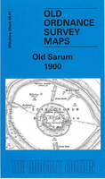
Old Sarum 1900
Old Sarum in 1900 in a fascinating series of reproductions of old Ordnance Survey plans in the Alan Godfrey Editions, ideal for anyone interested in the history of their neighbourhood or family. Selected towns in Great Britain and Ireland are covered by maps showing the extent of urban development in the last decades of the 19th and early 20th century.In this title: this detailed map covers the historic Old Sarum, the Roman Sorbiodunum, including the site of old cathedral. To the west is the village of Stratford sub Castle, including St Lawrence's church, Manor House, Parsonage Farm, site of Parliament Tree. To the east is Castle Hill, with Old Sarum Farm. On the reverse is an extract from the First Edition six-inch map of 1887-9, showing the area at an earlier stageAbout the Alan
Godfrey Editions of the 25
Godfrey Editions of the 25
Product Description
Reviews/Comments
Add New
Intelligent Comparison
Archived Product
Old Sarum 1900 Stanfords
£3.50
Archived Product
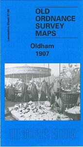
Oldham 1907 Stanfords
£3.50
Vouchers
No voucher codes found.
Do you know a voucher code for this product or supplier? Add it to Insights for others to use.
Do you know a voucher code for this product or supplier? Add it to Insights for others to use.
 Denmark