
 United Kingdom
 France
 Germany
 Netherlands
 Sweden
 USA
USA
 Italy
Italy
 Spain
Spain
More From Contributor

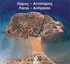


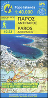
Paros - Antiparos Anavasi 10.23
Paros at 1:40, 000 on a light, waterproof and tear-resistant, contoured and GPS-compatible map from Anavasi with English language descriptions of best sights. Topography is very clearly presented by contours at 20m intervals enhanced by relief shading and altitude colouring. The map indicates dirt roads in poor condition and shows locations of bus stops. The marking for footpaths distinguishes between easy to find and faint trails. Publishers’ recommendations for best hikes are highlighted. Symbols indicate various facilities and places of interest including campsites, tavernas, beaches and windsurfing sites, marinas, etc. The map has a 1-km UTM grid plus latitude and longitude crosshairs at 1’. Map legend includes English.On the reverse is a map showing Antiparos at the same
scale, plus extensive bilingual notes on the island’s history and best sights.To see which other Greek islands are covered by maps from Anavasi, please click on the series link.
scale, plus extensive bilingual notes on the island’s history and best sights.To see which other Greek islands are covered by maps from Anavasi, please click on the series link.

Product Description
Reviews/Comments
Add New
Vouchers
No voucher codes found.
Do you know a voucher code for this product or supplier? Add it to Insights for others to use.
Do you know a voucher code for this product or supplier? Add it to Insights for others to use.
 Denmark