
 United Kingdom
 France
 Germany
 Netherlands
 Sweden
 USA
USA
 Italy
Italy
 Spain
Spain
More From Contributor
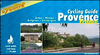

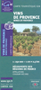

Provence Reise Know-How
Provence, French Riviera and the southern part French Alps at 1:250, 000 on a light, waterproof and tear-resistant map published by Reise Know-How as part of their highly acclaimed Wold Mapping Project. The map is double-sided, with a small overlap between the sides, and extends from the western side of the Rhône to the Italian border - coverage south of Avignon goes further west along the A9 motorway to Nîmes, Montpellier and Sète; in the north the map extends beyond the Ecrins and the Vercors massifs to Grenoble.Topography is presented by altitude colouring with names of mountain ranges, peaks, passes, etc; the region’s numerous national or regional parks are prominently highlighted. Road network indicates tolls and services (but not Aires de repos), and shows driving
distances on main and secondary routes. Symbols indicate various places of interest including campsites, viewpoints, historical and archaeological sites, etc. The map is indexed and has latitude and longitude lines at intervals at 10’ plus UTM margin ticks. Map legend includes English.
distances on main and secondary routes. Symbols indicate various places of interest including campsites, viewpoints, historical and archaeological sites, etc. The map is indexed and has latitude and longitude lines at intervals at 10’ plus UTM margin ticks. Map legend includes English.

Product Description
Reviews/Comments
Add New
Vouchers
No voucher codes found.
Do you know a voucher code for this product or supplier? Add it to Insights for others to use.
Do you know a voucher code for this product or supplier? Add it to Insights for others to use.
 Denmark