
 United Kingdom
 France
 Germany
 Netherlands
 Sweden
 USA
USA
 Italy
Italy
 Spain
Spain
More From Contributor


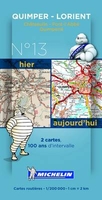
Quimper - Lorient Michelin Centenary Map-Pack
Quimper – Lorient Michelin Centenary Map-Pack, a set of two maps showing the area at 1:200, 000: a current road map from 2014 plus a reproduction from Michelin’s very first series of regional maps published between 1910 and 1924. The combination of the two maps shows not only how this area and its road network have developed but also provides an interesting comparison of the changes in the cartographic presentation over the past 100 years. The maps cover the western part of the southern coastline of Brittany including Camaret-sur-Mer, Crozon, Douarnenez, Châteaulin, Pont-l’Abbé, Concarneau and Quimperlé. The 2014 map is indexed and has a map legend in French only.To see the full list of the titles available in this series please click on the series link.

Product Description
Reviews/Comments
Add New
Vouchers
No voucher codes found.
Do you know a voucher code for this product or supplier? Add it to Insights for others to use.
Do you know a voucher code for this product or supplier? Add it to Insights for others to use.
 Denmark