More From Contributor
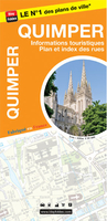
£12.99
Quiet London by Siobhan Wall showcases over 140 quiet places where you can meet, drink, eat, sleep, read, relax & recuperate in the capital. Discover unknown gems like atmospheric pubs & restaurant, peaceful & beautiful gardens or unusual museums & galleries & inviting shops. The book is organised in categories &

Includes::
museums, libraries, parks, gardens & nature reserves, places to relax & retreat centres, places of worship, small shops, restaurants & cafes, bookshops, places to have afternoon tea, galleries, pubs & wine bars, hotels & places to stay. Each entry is accompanied by an introductory text & an artistic mix of colour & black & white photographs, contact details including website, opening hours, the closest tube or train station & bus. Whether you looking for a quiet & gentle atmosphere for a special occasion or to take a break from the hassle & bustle of the city, Quiet London will guide you to the quietest places, in London.

...
Archived Product
£12.99
Paris is a beautiful city with astounding architecture & world-famous museums & restaurants. Because of its many attractions, however, it often feels as if there is nowhere to escape from the crowds. Siobhan Wall, author of Quiet Amsterdam & Quiet London, has sought out hidden, tranquil places so that Parisians can find some respite from their busy lives. She has gone in search of small museums & cafes so that visitors to the city can discover another, quieter side to this entrancing metropolis. From formal gardens to light-filled art galleries, chic boutiques, small tearooms & gourmet delicatessens, Quiet Paris has over one hundred & twenty tempting places to savour the quiet delights of this most seductive of cities. ...
Archived Product
£9.99
The highly anticipated follow-up to the sensational bestseller Quiet
- empowering introverted children, teens & young adults Susan
...
Archived Product
£9.50
Topographical survey of Belgium at 1:20, 000 from Nationaal Geografisch Instituut / Institut Géographique National, the country’s national survey organization. Each 20K map covers one quarter of the corresponding 1:50, 000 map (with adjustments in the border & coastal areas). The maps provide all the information expected of topographic mapping at this scale & in addition have an unusually large amount of vegetation and/or land use information (different types of woodlands, gardens, orchards, heath, etc). The maps have a 1-km UTM grid, with margin ticks for latitude & longitude at intervals of 1`. Map legend & a glossary of terms used on the maps include English. Stanfords keeps as regular stock 20K maps for the World War I battlefields around the Ypres, Messines & Passchendaele, & for the area of the Battle of Waterloo. The 1:20, 000 survey covers the whole of Belgium & maps for other regions can be supplied as special orders. To see the list of titles in this series please click on the series link.PLEASE NOTE: the Long-Distance Footpaths Map of Belgium at 1:300, 000 which shows the division of Belgium into the 50K survey sheets can also be used to see in more detail coverage by the 20K maps. ...
Archived Product
£7.99
Topographic survey of France at 1:25, 000 in IGN`s excellent TOP25 / Série Bleue series. All the maps are GPS compatible, with a 1km UTM grid plus latitude & longitude lines at 5’ intervals. Contours are at 5m intervals except for mountainous areas where the maps have contours at 10m intervals, vividly enhanced by hill shading & graphics for rocky terrain. Colouring with graphics indicates different types of vegetation or land use (deciduous or coniferous forests, moors, orchards, vineyards, etc). PLEASE NOTE: coverage of France at this scale is currently being revised – the format & the presentation of each title are indicated by the letters at the end of its Sheet Reference number (e.g. 0416ET, 3531ETR, 1923SB, etc.)MAPS WITH FULL TOURIST OVERPRINT & AN ENGLISH MAP LEGEND: all TOP25 maps & the SB editions of Série Bleue have an overprint highlighting waymarked walking trails including long-distance GR routes &, where appropriate, ski routes. Symbols indicate campsites, gîtes d’etape, refuges, equestrian centres & other recreational facilities or sites, tourist information centres, cultural heritage, etc. Towns & locations of particular interest are highlighted.- ET or OT = single-sided TOP25 map covering approx. 29x 21 km / 18x 13 miles.- ETR or OTR = waterproof & tear resistant TOP25 map covering the same area as the corresponding ET or OT number, but double-sided, printed on a smaller size sheet with a good overlap between the sides.- SB = Série Bleue map with full tourist overprint; these maps, first introduced in summer 2014, each cover approx. 29x 24km / 18x 15 miles.SÉRIE BLEUE maps with numbers ending in E (Est) or O (Ouest): most editions now indicate the GR routes, but do not show any other tourist information. Map legend is in French only. Each map covers approx. 14x 20km / 9x 12 miles. ...
Archived Product
£12.99
Topographic survey of France at 1:25, 000 in IGN`s excellent TOP25 / Série Bleue series. All the maps are GPS compatible, with a 1km UTM grid plus latitude & longitude lines at 5’ intervals. Contours are at 5m intervals except for mountainous areas where the maps have contours at 10m intervals, vividly enhanced by hill shading & graphics for rocky terrain. Colouring with graphics indicates different types of vegetation or land use (deciduous or coniferous forests, moors, orchards, vineyards, etc). PLEASE NOTE: coverage of France at this scale is currently being revised – the format & the presentation of each title are indicated by the letters at the end of its Sheet Reference number (e.g. 0416ET, 3531ETR, 1923SB, etc.)MAPS WITH FULL TOURIST OVERPRINT & AN ENGLISH MAP LEGEND: all TOP25 maps & the SB editions of Série Bleue have an overprint highlighting waymarked walking trails including long-distance GR routes &, where appropriate, ski routes. Symbols indicate campsites, gîtes d’etape, refuges, equestrian centres & other recreational facilities or sites, tourist information centres, cultural heritage, etc. Towns & locations of particular interest are highlighted.- ET or OT = single-sided TOP25 map covering approx. 29x 21 km / 18x 13 miles.- ETR or OTR = waterproof & tear resistant TOP25 map covering the same area as the corresponding ET or OT number, but double-sided, printed on a smaller size sheet with a good overlap between the sides.- SB = Série Bleue map with full tourist overprint; these maps, first introduced in summer 2014, each cover approx. 29x 24km / 18x 15 miles.SÉRIE BLEUE maps with numbers ending in E (Est) or O (Ouest): most editions now indicate the GR routes, but do not show any other tourist information. Map legend is in French only. Each map covers approx. 14x 20km / 9x 12 miles. ...
Archived Product
£6.99
Quimper – Lorient Michelin Centenary Map-Pack, a set of two maps showing the area at 1:200, 000: a current road map from 2014 plus a reproduction from Michelin’s very first series of regional maps published between 1910 & 1924. The combination of the two maps shows not only how this area & its road network have developed but also provides an interesting comparison of the changes in the cartographic presentation over the past 100 years. The maps cover the western part of the southern coastline of Brittany including Camaret-sur-Mer, Crozon, Douarnenez, Châteaulin, Pont-l’ Abbé, Concarneau & Quimperlé. The 2014 map is indexed & has a map legend in French only. To see the full list of the titles available in this series please click on the series link. ...
Archived Product
£7.50
Street plan of Quimper at 1:10, 000 from the Institut Géographique National, the country’s national survey organization, with an enlargement showing the city centre in greater detail, plus a diagram of the QUB bus network.IGN street plans include outer suburbs &, where appropriate, adjoining localities forming part of the urban agglomeration. The plans prominently highlight principal traffic arteries & show one way streets, car parks & pedestrian zones. Latest editions also indicate 24h petrol stations & streets with separate cycle paths. Many streets are annotated with selected house for easier identification of addresses. Important public buildings are named & symbols mark locations of tourist information centres & other facilities. Street index, arranged by an administrative area, is next to the map. Map legend

Includes::
English.PLEASE NOTE: to see the list of IGN street plans of French towns & cities please click on the series link – the series description also

Includes::
a comparison between IGN & Blay-Foldex street plans.


...
Archived Product
£12.99
Topographic survey of France at 1:25, 000 in IGN`s excellent TOP25 / Série Bleue series. All the maps are GPS compatible, with a 1km UTM grid plus latitude & longitude lines at 5’ intervals. Contours are at 5m intervals except for mountainous areas where the maps have contours at 10m intervals, vividly enhanced by hill shading & graphics for rocky terrain. Colouring with graphics indicates different types of vegetation or land use (deciduous or coniferous forests, moors, orchards, vineyards, etc). PLEASE NOTE: coverage of France at this scale is currently being revised – the format & the presentation of each title are indicated by the letters at the end of its Sheet Reference number (e.g. 0416ET, 3531ETR, 1923SB, etc.)MAPS WITH FULL TOURIST OVERPRINT & AN ENGLISH MAP LEGEND: all TOP25 maps & the SB editions of Série Bleue have an overprint highlighting waymarked walking trails including long-distance GR routes &, where appropriate, ski routes. Symbols indicate campsites, gîtes d’etape, refuges, equestrian centres & other recreational facilities or sites, tourist information centres, cultural heritage, etc. Towns & locations of particular interest are highlighted.- ET or OT = single-sided TOP25 map covering approx. 29x 21 km / 18x 13 miles.- ETR or OTR = waterproof & tear resistant TOP25 map covering the same area as the corresponding ET or OT number, but double-sided, printed on a smaller size sheet with a good overlap between the sides.- SB = Série Bleue map with full tourist overprint; these maps, first introduced in summer 2014, each cover approx. 29x 24km / 18x 15 miles.SÉRIE BLEUE maps with numbers ending in E (Est) or O (Ouest): most editions now indicate the GR routes, but do not show any other tourist information. Map legend is in French only. Each map covers approx. 14x 20km / 9x 12 miles. ...
Archived Product
£64.95
The Quincy 23cm (9) desktop globe is a sophisticated & charming antique-style raised-relief globe mounted atop a luxurious ...
Archived Product

Quimper

Street plan of Quimper, part of an extensive series covering French cities and towns from Blay-Foldex, the country’s largest, oldest and most experienced publisher of urban mapping.Blay plans include outer suburbs and, where appropriate, adjoining localities forming part of the urban agglomeration and provide brief descriptions of the town’s main sights, contact details for hotels and other places of interest, etc. The plans show one way streets, car parks and pedestrian zones. Important public buildings are clearly marked and identified. Blay street maps are usually double-sided and include an enlargement for the town centre and a street index with separate lists of “edifices publics”: main public buildings, places of worship, schools, sport facilities, stations, etc.
Each of the outer suburbs or the adjoining localities, identified with its postcode, has a separate index. Many titles also provide a road map of the environs. All the text is in French only.PLEASE NOTE: to see the list of Blay-Foldex street plans of French towns and cities please click on the series link – the series description also includes a comparison between Blay and IGN street plans.
RIP - This product is no longer available on our network. It was last seen on 25.09.2019

This page now acts as a permanent archive for this product. Add more information using the comments box below to ensure it can still be found by future generations.

Use our search facility to see if it is available from an alternative contributor.
  • Availability: Out Of Stock
  • Supplier: Stanfords
  • SKU: 9782309503048
Availability: In Stock
£6.99

Product Description

Street plan of Quimper, part of an extensive series covering French cities & towns from Blay-Foldex, the country’s largest, oldest & most experienced publisher of urban mapping. Blay plans include outer suburbs &, where appropriate, adjoining localities forming part of the urban agglomeration & provide brief descriptions of the town’s main sights, contact details for hotels & other places of interest, etc. The plans show one way streets, car parks & pedestrian zones. Important public buildings are clearly marked & identified. Blay street maps are usually double-sided & include an enlargement for the town centre & a street index with separate lists of “edifices publics”: main public buildings, places of worship, schools, sport facilities, stations, etc. Each of the outer suburbs or the adjoining localities, identified with its postcode, has a separate index. Many titles also provide a road map of the environs. All the text is in French only.PLEASE NOTE: to see the list of Blay-Foldex street plans of French towns & cities please click on the series link – the series description also

Includes::
a comparison between Blay & IGN street plans.

Reviews/Comments

Add New

Intelligent Comparison

Oooops!
We couldn't find anything!
Perhaps this product's unique.... Or perhaps we are still looking for comparisons!
Click to bump this page and we'll hurry up.

Price History

Vouchers

No voucher codes found.
Do you know a voucher code for this product or supplier? Add it to Insights for others to use.

Facebook

Jargon Buster

Car - A machine used for transport which runs on roads
Road - a manmade lane or a path that is used to speed up travel.

Supplier Information

Stanfords
Stanfords was established in 1853 and opened their iconic Covent Garden flagship store in 1901. They have become the top retailer of maps, travel books and accessories in the UK and arguably offer the largest selection of maps and travel books worldwide. Famous names such as Captain Robert Falcon Scott, Ranulph Fiennes and Michael Palin have purchased from Stanfords. They now have a shop in Bristol and both stores together with other venues operate a calendar of events including talks, book signings and exhibitions. As a specialist map retailer, the map selection is comprehensive and includes road maps, street maps and walking maps from worldwide destinations, as well as a selection of world atlases and wall maps. Books include travel guides and travel literature. Stanfords also stock globes, from miniatures made of blue marble to magnificent floor-standing globes. The website features a selection of interesting articles on travel topics.
Page Updated: 2023-11-12 20:15:36

Community Generated Product Tags

Oh No! The productWIKI community hasn't generated any tags for this product yet!
Menu