
 United Kingdom
 France
 Germany
 Netherlands
 Sweden
 USA
USA
 Italy
Italy
 Spain
Spain
More From Contributor


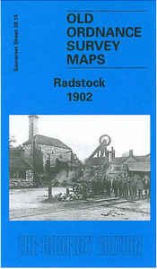
Radstock 1902
Radstock in 1902 in a fascinating series of reproductions of old Ordnance Survey plans in the Alan Godfrey Editions, ideal for anyone interested in the history of their neighbourhood or family. The map provides good coverage of Radstock and the surrounding area, stretching east to include Writhlington and west beyond Middle Pit Colliery and Wells Road. Features include Radstock town centre with its busy railway lines, the Collieries of Tyning, Ludlow`s, Upper Writhlington and Lower Writhlington, St Nicholas`s Church, St Mary Magdalen`s Church, Tramway, Radstock Mill, and Brewery. We do not think of Somerset as an industrial county, but the Radstock map is certainly an industrial one, with its 4 collieries, 2 wagon works, complex of railways, and miners` housing on the
hillside. About the Alan Godfrey Editions of the 25” OS SeriesSelected towns in Great Britain and Ireland are covered by maps showing the extent of urban development in the last decades of the 19th and early 20th century. The plans have been taken from the Ordnance Survey mapping and reprinted at about 15 inches to one mile (1:4, 340). On the reverse most maps have historical notes and many also include extracts from contemporary directories. Most maps cover about one mile (1.6kms) north/south, one and a half miles (2.4kms) across; adjoining sheets can be combined to provide wider coverage.FOR MORE INFORMATION AND A COMPLETE LIST OF ALL AVAILABLE TITLES PLEASE CLICK ON THE SERIES LINK.
hillside. About the Alan Godfrey Editions of the 25” OS SeriesSelected towns in Great Britain and Ireland are covered by maps showing the extent of urban development in the last decades of the 19th and early 20th century. The plans have been taken from the Ordnance Survey mapping and reprinted at about 15 inches to one mile (1:4, 340). On the reverse most maps have historical notes and many also include extracts from contemporary directories. Most maps cover about one mile (1.6kms) north/south, one and a half miles (2.4kms) across; adjoining sheets can be combined to provide wider coverage.FOR MORE INFORMATION AND A COMPLETE LIST OF ALL AVAILABLE TITLES PLEASE CLICK ON THE SERIES LINK.

Product Description
Reviews/Comments
Add New
Intelligent Comparison
Archived Product

Tavistock 1905 Stanfords
£3.50
Archived Product
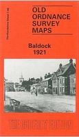
Baldock 1921 Stanfords
£3.50
Vouchers
No voucher codes found.
Do you know a voucher code for this product or supplier? Add it to Insights for others to use.
Do you know a voucher code for this product or supplier? Add it to Insights for others to use.
 Denmark