
 United Kingdom
 France
 Germany
 Netherlands
 Sweden
 USA
USA
 Italy
Italy
 Spain
Spain
More From Contributor


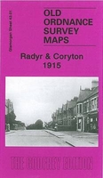
Radyr And Coryton 1915
Radyr and Coryton in 1915 in a fascinating series of reproductions of old Ordnance Survey plans in the Alan Godfrey Editions, ideal for anyone interested in the history of their neighbourhood or family. The map covers the northern part of Radyr and western part of Whitchurch. Coverage stretches from Driscoll Road eastward to Kelston Road and from Velindra Road northward to part of Morganstown. Features include River Taff, Glamorganshire Canal, Melin-Griffith Feeder, Cardiff City Mental Hospital, Velindre, northern tip of Melin-Griffith Tin Works, Coryton, Forest Farm, Cardiff Railway with Coryton Halt, Taff Vale Railway with Radyr station, Penarth Junction, sidings, Mynydd Wood, Windsor Road area of Radyr, Ty-mynydd Farm, Melin-Griffith & Pentyrch Railway, St Dyfrig`s RC
church, St Mary`s church, Dynea Colliery (disused), Glyn-Taf, old mineral tramway route, Treforest Junction, Electrical Works, etc. On the reverse are 1906 directories for Radyr and Whitchurch.About the Alan Godfrey Editions of the 25” OS Series:Selected towns in Great Britain and Ireland are covered by maps showing the extent of urban development in the last decades of the 19th and early 20th century. The plans have been taken from the Ordnance Survey mapping and reprinted at about 15 inches to one mile (1:4, 340). On the reverse most maps have historical notes and many also include extracts from contemporary directories. Most maps cover about one mile (1.6kms) north/south, one and a half miles (2.4kms) across; adjoining sheets can be combined to provide wider coverage.FOR MORE
INFORMATION AND A COMPLETE LIST OF ALL AVAILABLE TITLES PLEASE CLICK ON THE SERIES LINK.

Product Description
Reviews/Comments
Add New
Vouchers
No voucher codes found.
Do you know a voucher code for this product or supplier? Add it to Insights for others to use.
Do you know a voucher code for this product or supplier? Add it to Insights for others to use.
 Denmark