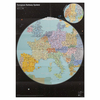
More From Contributor

£13.99
Across the country, more than 1600 unused railroad corridors have been converted to level, public, multiuse trails, where people can enjoy a fitness run, a leisurely bike ride, or a stroll with the family. In this new guide in the popular series, the Rails-to-Trails Conservancy presents the Northwest region`s finest rail-trails plus other great multiuse trails. Rail-Trails Washington & Oregon

Includes::
detailed coverage of more than 40 great trails. Many rail-trails are paved & run through the most scenic parts of town. Others travel along dense forests, open fields, & lush waterways. Some explore the area`s history, & others help users enjoy the serenity of the rural countryside. Favorites noted by Rails-to-Trails Conservancy staff include the Chehalis Western Trail & Olympic Discovery Trail in Washington & the Banks-Vernonia State Trail in Oregon. This full-color book

Includes::
succinct descriptions of each trail from start to finish, plus at-a-glance summary information indicating permitted uses, surface type, length, & directions to trailheads for each trail. Every trip has a detailed map that

Includes::
start & end points, trailhead, parking, restroom facilities, & other amenities.


...
Archived Product
£25.00
Rails Across Britain is a collection of full-size colour photographs of trains that have operated in Great Britain over the last thirty years. Compiled by a well-regarded author of several successfully published books showing many varying classes of trains throughout the world, this book covers the period from 1986 to the present day. It brilliantly illustrates the various classes & the huge myriad of colour schemes that have been used throughout the years, from the great days of the British Rail to the era of Privatisation. The contrast between the cash-strapped British Rail from an almost universal blue & grey colour scheme, to the well-funded privatised multi-coloured system seen today, is well portrayed in this comprehensive album, in which more than one photo of a class is shown. This selection of photographs have been specifically chosen to demonstrate an undeniably wide range of locations from Fort William in Scotland to St Austell in Cornwall, &, of course, in a variety of British weather conditions. The emphasis is, therefore, on the beauty of the train in its surroundings. ...
Archived Product
£25.00
The two volumes covering Rails Across Europe are divided into one covering the North & West of the continent, the other dealing with the South & East. The photos were taken by David Cable, well-regarded author of several photographic albums of trains throughout the world, supplemented by a few taken by friends. The books show pictures of modern traction mainly from the 1980s up to the current era, showing the huge variety of classes
- locomotives as well as multiple units
- & the panoply of colour schemes that continue to grow. The photos were taken both at railway stations & in the countryside & give a wide range of locations The first volume covers Scandinavia, the Baltic states, Germany, Pol&, the Benelux countries, the United Kingdom & Irel&. The second volume deals with France, Spain, Portugal, Italy, Switzerl&, Austria & the majority of Central European & Balkan countries, which had been in the former Soviet Eastern Block.

...
Archived Product
£25.00
The two volumes covering Rails Across Europe are divided into one, covering the North & West of the continent, the other dealing with the South & East. The photos were taken by David Cable, a well-regarded author of several photographic albums of trains throughout the world, supplemented by a few taken by friends. The books show pictures of modern traction mainly from the 1980s to the current era, covering the huge variety of classes
- locomotives as well as multiple units
- & the panoply of colour schemes that continue to grow. The photos were taken both at railway stations & in the countryside & give a wide range of locations. The first volume covers Scandinavia, the Baltic states, Germany, Pol&, the Benelux countries, the United Kingdom & Irel&. The second volume deals with France, Spain, Portugal, Italy, Switzerl&, Austria & the majority of Central European & Balkan countries, which had been in the former Soviet Eastern Block.

...
Archived Product
£7.99
Britain`s rail network is now among the safest in the world, but the journey that brought it to that point has been long & eventful. Early incidents like the felling of William Huskisson MP by Stephenson`s Rocket (1830) showed how new ideas could bring new dangers; yet from disaster came new safety measures, & within fifty years better signalling & braking methods had been made mandatory. The twentieth century saw accident repeatedly lead to action & further advances in rolling stock, track design & train protection systems. Greg Morse charts these changes through the events that helped to prompt them, including the Armagh collision (1889) & the Harrow & Wealdstone disaster (1952). He ends with a railway approaching a new `golden age` in the 1980s
- yet with the tragedy at Clapham Junction (1988) offering a solemn reminder against complacency.
...
Archived Product
£19.99
There is an undoubted fascination both with railway atlases & with the ' Then & Now' approach to railway history. Unlike any other atlas published, The Railway Atlas Then & Now provides historical & present-day maps alongside each other for direct comparison. Based around the ' Pre-Grouping Atlas & Gazetteer', the left-hand of the two maps records the railway industry as it existed in 1923, whilst the right-hand page shows it as it exists today. The contemporary 2012 maps include information about the railway lines that have been closed & converted into either walking or cycling routes. Other information given

Includes::
the location of all steam sheds & current diesel depots. The book

Includes::
45 maps from each period
- making a total of 90pp of mapping in all
- alongside a detailed gazetteer & brief introduction.


...
Archived Product
£1.99
When Father goes away with two strangers one evening, the lives of Roberta, Peter & Phyllis are shattered. They & their mother have to move from their comfortable London home to go & live in a simple country cottage, where Mother writes books to make ends meet. However, they soon come to love the railway that runs near their cottage, & they make a habit of waving to the Old Gentleman who rides on it. They befriend the porter, Perks, & through him learn railway lore & much else. They have many adventures, & when they save a train from disaster, they are helped by the Old Gentleman to solve the mystery of their father`s disappearance. ...
Archived Product
£6.99
European Railway System is a paper poster railway map presenting the rail network of some 30 countries designed in the image of the Earth as seen from space. On the back, the European countries are represented as planets. The departing railway stations are craters of the planets & the destinations are moon links to the craters. ...
Archived Product
£6.99
NYC Railway System is a paper poster railway map of New York City inspired by the shape of the heart from Milton Glaser`s ”I heart NY” logo. Famous landmarks & tourist attractions such as the Empire State Building are incorporated into the map, creating a sense of New York City as a tourist spot. City Railway System is a new approach to projecting the identity of a city onto its subway map. Whereas conventional subway maps aim at conveying information as clearly & concisely as possible, the City Railway System by Zero Per Zero instinctively incorporates symbolic elements of each city into its map while preserving clarity. As a special consideration for tourists, major landmarks & tourist attractions are indicated on the subway maps, so that tourists can easily figure out the quickest way to get to the destination at a glance. The railway map itself is also good as a souvenir. ...
Archived Product

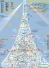
Railway Atlas Of Ireland Then & Now

This new atlas compares the railway network in Ireland in 1920 with the network today. It is produced by the same authors as the successful Railway Atlas Then & Now which covers the railways in Britain and will follow the same layout and design which shows the historical map on one page and the current map on the facing page for comparison. As in Britain, the Irish railway network was built in the 19th century by numerous independent railway companies. Many of these were speculative ventures and served underpopulated rural areas and many were gradually taken over by larger railway groups. The main lines were split between eight major companies but there were numerous other smaller companies that maintained their independence but many, however, failed to generate their predicted revenue.
1920 was the peak year in the Irish railway network but the civil war and partition that followed that decade had a severe impact on the railways. Traffic declined still further during World War 2 and during the 1950s and 1960s swathes of the railway network were closed so that today`s network is only about half the size of that in 1920.The railways were built to a variety of gauges and the atlas will include the narrow gauge passenger railways as well as those built to the standard gauge in Ireland. The maps will be supplemented by historical photographs and a potted history of each line, with a timeline. There has long been an interest in Irish railways among British railway enthusiasts as well as those based in Ireland and this book will be a worthy addition to Ian Allan`s unrivalled
library of railway atlases, providing a comprehensive historical record of the changes in the railway system in Ireland.
RIP - This product is no longer available on our network. It was last seen on 25.09.2019

This page now acts as a permanent archive for this product. Add more information using the comments box below to ensure it can still be found by future generations.

Use our search facility to see if it is available from an alternative contributor.
  • External links may include paid for promotion
  • Availability: Out Of Stock
  • Supplier: Stanfords
  • SKU: 9780711037960
Availability: In Stock
£20.00

Product Description

This new atlas compares the railway network in Ireland in 1920 with the network today. It is produced by the same authors as the successful Railway Atlas Then & Now which covers the railways in Britain & will follow the same layout & design which shows the historical map on one page & the current map on the facing page for comparison. As in Britain, the Irish railway network was built in the 19th century by numerous independent railway companies. Many of these were speculative ventures & served underpopulated rural areas & many were gradually taken over by larger railway groups. The main lines were split between eight major companies but there were numerous other smaller companies that maintained their independence but many, however, failed to generate their predicted revenue. 1920 was the peak year in the Irish railway network but the civil war & partition that followed that decade had a severe impact on the railways. Traffic declined still further during World War 2 & during the 1950s & 1960s swathes of the railway network were closed so that today`s network is only about half the size of that in 1920. The railways were built to a variety of gauges & the atlas will include the narrow gauge passenger railways as well as those built to the standard gauge in Irel&. The maps will be supplemented by historical photographs & a potted history of each line, with a timeline. There has long been an interest in Irish railways among British railway enthusiasts as well as those based in Ireland & this book will be a worthy addition to Ian Allan`s unrivalled library of railway atlases, providing a comprehensive historical record of the changes in the railway system in Irel&.

Reviews/Comments

Add New

Intelligent Comparison

Oooops!
We couldn't find anything!
Perhaps this product's unique.... Or perhaps we are still looking for comparisons!
Click to bump this page and we'll hurry up.

Price History

Vouchers

No voucher codes found.
Do you know a voucher code for this product or supplier? Add it to Insights for others to use.

Facebook

Jargon Buster

History - Anything that happens in the past. An acedemic subject.
Railways - A set of tracks that have been laid for the purpose of trains to travel up and down them
World - A physical grouping, commonly used to describe earth and everything associated with ti
Year - The time it takes the planet earth to orbit the sun. This takes around 365.25 days.
Size - is the measurement of how big an object is in space.
Network - A link and communication between things. Often computers or people.
Year - 365 days (366 days in a leap year), the time taken for planet earth to make one full revolution around the sun.
Design - A drawing or styles that shows the look and functionality of something before its made.

Supplier Information

Stanfords
Stanfords was established in 1853 and opened their iconic Covent Garden flagship store in 1901. They have become the top retailer of maps, travel books and accessories in the UK and arguably offer the largest selection of maps and travel books worldwide. Famous names such as Captain Robert Falcon Scott, Ranulph Fiennes and Michael Palin have purchased from Stanfords. They now have a shop in Bristol and both stores together with other venues operate a calendar of events including talks, book signings and exhibitions. As a specialist map retailer, the map selection is comprehensive and includes road maps, street maps and walking maps from worldwide destinations, as well as a selection of world atlases and wall maps. Books include travel guides and travel literature. Stanfords also stock globes, from miniatures made of blue marble to magnificent floor-standing globes. The website features a selection of interesting articles on travel topics.
Page Updated: 2023-11-12 20:15:36

Community Generated Product Tags

Oh No! The productWIKI community hasn't generated any tags for this product yet!
Menu