
 United Kingdom
 France
 Germany
 Netherlands
 Sweden
 USA
USA
 Italy
Italy
 Spain
Spain
More From Contributor


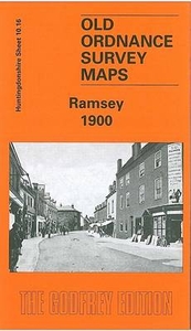
Ramsey 1900
Ramsey in 1900 in a fascinating series of reproductions of old Ordnance Survey plans in the Alan Godfrey Editions, ideal for anyone interested in the history of their neighbourhood or family. Selected towns in Great Britain and Ireland are covered by maps showing the extent of urban development in the last decades of the 19th and early 20th century.In this title: the map is double-sided and covers the centre of the town, extending eastward to Cook's Lane. Features include St Thomas a Becket's church, Ramsey Abbey, Booth's Hill, Great Whyte, chapels, town centre with individual buildings neatly shown, Northey Farm, Church Green, cemetery etc. On the reverse is part of the adjacent sheet 10.15 covering the western part of the town. Features here include Britannia Iron Works
(disused), GN&GE Joint station, GER station (at top of map), The Field, Field Foundry. About the Alan Godfrey Editions of the 25
(disused), GN&GE Joint station, GER station (at top of map), The Field, Field Foundry. About the Alan Godfrey Editions of the 25

Product Description
Reviews/Comments
Add New
Intelligent Comparison
Archived Product
Ramsey 1900 Stanfords
£3.50
Archived Product

Ramsgate 1905 Stanfords
£3.50
Vouchers
No voucher codes found.
Do you know a voucher code for this product or supplier? Add it to Insights for others to use.
Do you know a voucher code for this product or supplier? Add it to Insights for others to use.
 Denmark