More From Contributor
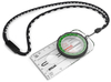
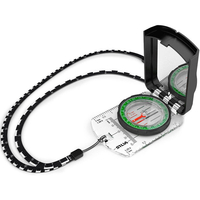
£9.99
Did you know that Napoleon was once attacked by rabbits? Or that the Mars Rover sang itself ” Happy Birthday”? How about the odd ingredient Civil War soldiers used to make coffee? From the illustrator behind The Kid`s Awesome Activity Calendar & Doodle Adventures comes a collection of obscure, fascinating facts, each captured in Lowery`s signature quirky style. With full-page illustrations as well as handwritten webs of interconnected facts, the book will be teeming with unusual & entertaining trivia. ...
Archived Product
£23.99
Randonnées dans les vignes de l’ Ile de France from Rando Editions offers 30 walks in the region, with three routes in the capital itself: in Montmartre, Père-Lachaise
- Belleville area, & from Jardins des Plantes to Bercy. Most are in the outer suburbs, easily accessible by metro or RER. All the routes, between one & five hours long, start & end at or near a metro, RER or SNC station. The routes are designed to include not only small local vineyards but also various historical monuments, interesting streets, etc. * Route instructions are in easily accessible French*, & are cross-referenced to street plans or detailed maps overprinted with the route. Longer descriptions provide historical background for places of interest. Each route is annotated with information about metro/rail &, where appropriate, road access. Also included are recommendations for local bistrots à vin, opening hours of museums, etc.
...
Archived Product
£20.50
Randonnées en Franche-Comté de gare en gare, FFRP topo-guide Ref. No. RE18, with 28 day walks of varying length & difficulty in the French Jura between Belfort & St-Claude. Each walk links two SNCF stations & is presented on a separate colour extract from IGN’s topographic survey of France at 1:25, 000, with its description cross-referenced to the map. Current edition of this title was published in October 2011. To see the list of other FFRP guides with day walks please click on the series link.ABOUT THE FFRP (Fédération française de la randonnée pédestre) TOPOGUIDES: published in a handy A5 paperback format, the guides are the best companions for hiking in France. In addition to their topo-guides to the long-distance GR routes FFRP also publish an extensive range of guides with local day walks. Each walk in presented on a colour extract from IGN`s 1:50, 000 or 1:25, 000 topographic survey mapping overprinted with the route, with important points cross-referenced to the accompanying text, in French only, placed on the adjoining page. For each walk the guides also indicate the degree of difficulty & provide information on length, time & change in altitude, waymarking signs, access by road & parking facilities. An “info practiques” section of the guide indicates where shops, restaurants & accommodation can be found. The guides are published on high quality paper & include descriptions of the most interesting aspects of the surrounding region: historical & cultural sites, local specialties, fauna & flora, etc, all illustrated with colour photos. ...
Archived Product
£29.99
A traditional base-plate compass, ideal for hiking, trekking & Duke of Edinburgh award expeditions. With a detachable safety-release lanyard & luminous markings for night navigation, the Silva Ranger compass is a convenient & handy piece for anyone relying an map navigation to get where they%27re going. The Silva Ranger features Dry Flex™ grip for easy handling & comes with a use-anywhere declination scale inside the capsule, a magnifying lens & base plate map (measuring in mm & scales of 1:50, 000 & 1:25, 000).- Dry Flex™ Rubber grip: Easy handling of the compass detachable safety-release lanyard- Declination scale inside the capsule: can be used anywhere- Map measuring scales (mm & inch): 1:50, 000 & 1:25, 000- Luminous marking enable night navigation- Weight: 33g ...
Archived Product
£9.99
If you`re like most kids who love the outdoors, you want to do more than go on picnics or hike a nature trail. You don`t want to go home at the end of the day. You want to stay out in the woods, mountains, or desert. You want to camp. With Ranger Rick Kids` Guide to Camping, you`ll learn how to make roughing it easy. You`ll find great tips for choosing the best campsite & setting up your home away from home. You`ll even find recipes for great fireside dishes. Also included is a real working compass to help you navigate through the wilderness. It might take you a while to read this book, because it is filled with ideas for things to do. You might stop reading right in the middle of a page to go out & try a new camping skill. & that`s great, because the better you get at those skills, the more fun you`ll have on your camping adventure. ...
Archived Product
£6.99
John Flanagan makes a spectacular return to the world of Ranger`s Apprentice
- but what has happened since you last saw Will &
...
Archived Product
£55.00
Intricately crafted with timeless tradition, this carefully dyed sisal fiber & sweet grass vase makes a stunning statement ...
Archived Product
£9.99
Every morning Ajji`s village is decorated with rangolis. Dots, lines, flower designs, on the ground on the wall, everywhere. Food for ants & fun for birds, dogs & children. This delightful book makes a wonderful introduction to the art of rangoli through the medium of a simple story that illustrates the appeal of this popular art form. ...
Archived Product
£36.95
Military topographic survey mapping with contours. These maps are designed primarily as flying charts for aircraft, but they are useful as general topographical maps where nothing else is available. Contours are shown in feet, with elevation colouring & spot heights. Towns, villages, major roads, railways & airports are shown (but please note that many of the smaller settlements are not named, & the road information is not necessarily up to date). Some air navigation information also appears on the map, such as radio beacons & restricted flying zones. Double-sided sheet. ...
Archived Product
£24.95
This book provides a compendium of stimulating facts about the states, presented graphically, & covering a wide array of topics including demographic, economic, environmental, health, & crime variables. Hundreds of attributes are compared side-by-side, from life expectancy to murder rates; from fourth-grade math proficiency scores to the number of food stamp recipients, & from illicit drug use to the rate of firearm background checks per state. Through meticulous organization & use of graphic formats, retrieval of specific information the reader may seek has been greatly facilitated. In addition to the graphs comparing the fifty states for each individual metric, a summary table is provided at the beginning of each chapter along with highlights of pertinent data found in the chapter. While we are one, indivisible nation, at the same time Americans are as diverse from state-to-state as many nations are when compared with other nations. For example: in 2010, 95 percent of Vermont residents were white compared with only 24 percent of residents in Hawaii & 1-in-12 New York residents were Jewish compared with less than 1-in-1, 000 Arkansas residents. In Texas, 464 prisoners have been executed over the past 35 years while 16 states have not executed any. More interesting facts found in ranking America`s Fifty States include: * Alaska ranked highest or lowest in 31 metrics-more than any other state-followed by Mississippi at 25 & Texas at 20. * Alaska is the only state that does not have a state income tax or a state sales tax. It had the highest revenues per capita from taxes levied on businesses for the extraction of oil & gas & receives the highest federal aid per capita. Alaska had the lowest percent of households with annual income below $15, 000. * Over the past decade, over 100 million firearms background checks have been performed nationally, with the highest rate in Utah & the lowest rate in New Jersey * Mississippi had the lowest personal income per capita, median household income, gross domestic product per capita, & lowest male life expectancy rate. in addition, it had the highest food stamp recipient rate, rate of persons below the poverty level, & infant mortality rate. * Florida had the highest rate of identity theft victims in 2010 followed by Arizona, California, & Georgia.* Texas had the most extreme environmental metrics including the highest major disaster, storm, & wildfire emergency declarations. Texas also had the highest summer air temperature & carbon dioxide emissions level. In addition to extreme environmental metrics, Texas also had the highest property crime rate & high school dropout rate. ...
Archived Product

Ranger S Compass

This compass features a distance lanyard; a lanyard with scales (1:25, and 1:50) which facilitates to measure the distance of your hike.Silva Ranger S features DryFlex™ grip for easy handling and comes with a use-anywhere declination scale inside the capsule. A base plate map-measuring in mm and scales of 1:50, 000 and 1:25, 000. Ranger S has the additional benefit of 45-degree angle assistance on the mirror sighting function. A go-anywhere tool for serious compass users.The lanyard is soft and bendable and easy to place directly on to your route on the map. The new graphics contain a more distinct arrow (Ranger) and also a more contemporary font. The colors change to green and black to harmonize with the other outdoor assortment. If you are looking for a basic but yet functional
compass for your outdoor adventure, Ranger should be your choice. Thanks to the magnifier you can make sure to see every detail on the map.
RIP - This product is no longer available on our network. It was last seen on 25.09.2019

This page now acts as a permanent archive for this product. Add more information using the comments box below to ensure it can still be found by future generations.

Use our search facility to see if it is available from an alternative contributor.
  • Availability: Out Of Stock
  • Supplier: Stanfords
  • SKU: 7318860194900
Availability: In Stock
£49.99

Product Description

This compass features a distance lanyard; a lanyard with scales (1:25, & 1:50) which facilitates to measure the distance of your hike. Silva Ranger S features Dry Flex™ grip for easy handling & comes with a use-anywhere declination scale inside the capsule. A base plate map-measuring in mm & scales of 1:50, 000 & 1:25, 000. Ranger S has the additional benefit of 45-degree angle assistance on the mirror sighting function. A go-anywhere tool for serious compass users. The lanyard is soft & bendable & easy to place directly on to your route on the map. The new graphics contain a more distinct arrow (Ranger) & also a more contemporary font. The colors change to green & black to harmonize with the other outdoor assortment. If you are looking for a basic but yet functional compass for your outdoor adventure, Ranger should be your choice. Thanks to the magnifier you can make sure to see every detail on the map.

Reviews/Comments

Add New

Intelligent Comparison

Oooops!
We couldn't find anything!
Perhaps this product's unique.... Or perhaps we are still looking for comparisons!
Click to bump this page and we'll hurry up.

Price History

Vouchers

No voucher codes found.
Do you know a voucher code for this product or supplier? Add it to Insights for others to use.

Facebook

Jargon Buster

Contemporary - Modern era design
Black - A colour which does not emit any colour of the spectrum. Black absorbs all frequencies of the spectrum.
Contemporary - A design reference to indicate post war modern design
soft - A descriptive word for an item/sound which is gentle to the touch or ears
Graphics - A general term for visual aspects of an item/display
Adventure - an undertaking of an exciting challenge or experience.
Contemporary - An object that is living in the same time.
Degree - An angle measurement, also can be the measurement of an extent that something happens, can also relate to an university academic measurement.
degree - The extremity of something or the angle. Can also relate to a university achievement.
Distinct - Something that can be seen to be slightly different.

Supplier Information

Stanfords
Stanfords was established in 1853 and opened their iconic Covent Garden flagship store in 1901. They have become the top retailer of maps, travel books and accessories in the UK and arguably offer the largest selection of maps and travel books worldwide. Famous names such as Captain Robert Falcon Scott, Ranulph Fiennes and Michael Palin have purchased from Stanfords. They now have a shop in Bristol and both stores together with other venues operate a calendar of events including talks, book signings and exhibitions. As a specialist map retailer, the map selection is comprehensive and includes road maps, street maps and walking maps from worldwide destinations, as well as a selection of world atlases and wall maps. Books include travel guides and travel literature. Stanfords also stock globes, from miniatures made of blue marble to magnificent floor-standing globes. The website features a selection of interesting articles on travel topics.
Page Updated: 2023-11-12 20:15:36

Community Generated Product Tags

Oh No! The productWIKI community hasn't generated any tags for this product yet!
Menu