
 United Kingdom
 France
 Germany
 Netherlands
 Sweden
 USA
USA
 Italy
Italy
 Spain
Spain
More From Contributor


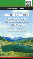
Rodnei Mountains
Rodnei Mountains in northern Romania presented at 1:50, 000 on a map from Dimap - one of Hungary’s leading cartographic publishers specializing in mapping Transylvania, showing local hiking routes, campsites, places of interest, etc. Contours are at 50m intervals, enhanced by relief shading and colouring for forested areas. The map shows local roads and footpaths, and additional overprint highlights waymarked trails indicating their waymarking signage. Also marked are different types of local tourist accommodation such as hotels, pensions, campsites, mountain refuges, forest lodges, etc. Symbols mark various places of interest and facilities, including locations of petrol stations. The map has latitude and longitude grid at 1’ intervals. On the reverse is a black and white
road map at 1:400, 000 showing the surrounding region, notes describing the area, plus details of accommodation facilities and hiking trails. Map legend and all the notes include English.
road map at 1:400, 000 showing the surrounding region, notes describing the area, plus details of accommodation facilities and hiking trails. Map legend and all the notes include English.

Product Description
Reviews/Comments
Add New
Vouchers
No voucher codes found.
Do you know a voucher code for this product or supplier? Add it to Insights for others to use.
Do you know a voucher code for this product or supplier? Add it to Insights for others to use.
 Denmark