
 United Kingdom
 France
 Germany
 Netherlands
 Sweden
 USA
USA
 Italy
Italy
 Spain
Spain
More From Contributor


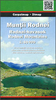

Rodnei Mountains Hiking Map And Guide
Rodnei Mountains at 1:50, 000 from Bel Alpin on a contoured walking map with a 32-page guide providing descriptions of 23 hiking routes and 51km-long traverse along the ridge route across the whole lengths of the chain.The map has contours at 40m intervals with additional shading and colouring for woodlands. An overprint highlight hiking routes, indicating waymarking and shows chalets, refuges, campsites, hunting lodges, mountain rescue posts, etc. The map has grid lines showing latitude and longitude at intervals of 2’.The 32-page guide attached to the map cover provides descriptions of 23 hiking trails and of the 51km-long main ridge route, with separate descriptions for the traverse in the westerly and the easterly directions. The guide also provides information on tourist
accommodation and a general description of the area. All the text is in English.
accommodation and a general description of the area. All the text is in English.
Product Description
Reviews/Comments
Add New
Vouchers
No voucher codes found.
Do you know a voucher code for this product or supplier? Add it to Insights for others to use.
Do you know a voucher code for this product or supplier? Add it to Insights for others to use.
 Denmark