
 United Kingdom
 France
 Germany
 Netherlands
 Sweden
 USA
USA
 Italy
Italy
 Spain
Spain
More From Contributor


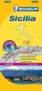
Sicily Marco Polo Map
Sicily at 1:200, 000 from Marco Polo Travel Publishing with special features to aid navigation and route planning. The index booklet includes street plans of central Catania, Messina and Palermo. A fold-out extension of the map cover gives at-a-glance overview of Sicily with the adjoining mainland, making it much easier to find various places on the main map and/or plan a route. A set of seven peel-on/peel-off stickers, removable without damaging the map, is provided to make routes or locations more prominent when navigating.The map boldly stresses main roads and motorways in strong colours and selected towns in large letters, but also shows minor roads and villages in considerable detail. Road information includes toll roads, traffic restrictions and seasonal closures, gradient
marking for steep roads, scenic routes, etc. Motorway services clearly indicate types of facilities available there. Railway lines are shown with stations.Cartography from the renowned German publishers MairDumont is particularly good for identifying geographical features: mountain and hill chains, valleys, national parks, etc. Picturesque towns and places of interest are given star rating, and other tourist information includes campsites and youth hostels, landmarks, recreational facilities etc. Latitude and longitude grid is drawn at intervals of 10`. Multilingual map legend and all information include English.A booklet attached to the map cover contains street plans of central Catania, Messina and Palermo, plus an extensive index of place names including geographical features
such as rivers, lakes, mountains, etc, as well as places of interest. Also provided is a table with distances/traveling times, plus main traffic and speed regulations.

Product Description
Reviews/Comments
Add New
Intelligent Comparison
Archived Product

USA Marco Polo Map Stanfords
£6.99
Archived Product

Mexico Marco Polo Map Stanfords
£6.99
Archived Product
Alps Marco Polo Map Stanfords
£6.99
Archived Product

Tunisia Marco Polo Map Stanfords
£5.99
Archived Product

Egypt Marco Polo Map Stanfords
£4.99
Archived Product

Switzerland Marco Polo Map Stanfords
£6.99
Archived Product
Norway Marco Polo Map Stanfords
£6.99
Archived Product

Turkey Marco Polo Map Stanfords
£6.99
Vouchers
No voucher codes found.
Do you know a voucher code for this product or supplier? Add it to Insights for others to use.
Do you know a voucher code for this product or supplier? Add it to Insights for others to use.
 Denmark