More From Contributor

£11.19
Laminated waterproof edition of a detailed topographic map from the Ordnance Survey Explorer series, covering Stroud, Tetbury & Malmesbury (showing part of the Costwold Way & Thames Path). Edition A2; Publication date February 2012 About this series: These highly detailed maps show all the administrative boundaries, settlements as small as isolated farms, the road network down to unfenced roads & country tracks, & field boundaries (hedges & drystone walls) which make navigation across the countryside much easier. Steep gradients on roads are indicated. Various landmarks, e.g. powerlines, archaeological sites, windmills, churches & lighthouses are shown & additional graphics indicate natural terrain features such as cliffs, scree, mud & vegetation variations. The contour interval is 5 metres in the lower parts of the country & 10 metres in the uplands, & spot heights are marked. Each map covers an area of 30 x 20km (i.e. approx. 19 x 12 miles), with some double-sided maps covering more, as indicated in the individual descriptions. The maps are fully GPS compatible, with the National Grid shown at 1km intervals & latitude & longitude indicated by margin ticks at 1'. The Explorer series has replaced the earlier, green-cover Pathfinder maps. The Explorer series is now complete & covers all of Engl&, Wales & Scotl&. Some sheets for popular areas like the National Parks are still branded as Outdoor Leisure (OL) maps, but are now included in this series as the cartography is the same as that in the Explorer Maps. The Explorer maps offer a substantial improvement on the Pathfinder series, with greater use of colour, larger area per map, & stronger emphasis on information for ramblers & tourists. This series is ideal for walking & other outdoor pursuits & each map shows a large amount of information for ramblers & tourists. Public rights of way are shown (except in Scotland), together with other routes with public access: National Trails & Recreational Paths, permitted paths & bridleways, & selected cycle routes. Open access land created under the Countryside & Rights of Way Act 2000 is marked. Tourist information

Includes::
caravan & campsites, Park & Ride locations, recreation/leisure/sport centres, museums, historic buildings, English Heritage & National Trust sites, rural pubs, etc. The map legend is in English only, except for the tourist information content which is also in French & German.

...
Archived Product
£14.99
Stroud, Tetbury & Malmesbury area on a detailed topographic & GPS compatible map No. 168, waterproof version, from the Ordnance Survey’s 1:25, 000 Explorer series. MOBILE DOWNLOADS: this title & all the other OS Explorer maps include a code for downloading after purchase the digital version onto your smartphone or tablet for viewing on the OS smartphone app.OS EXPLORER SERIES: to see the list of all the titles in the OS Explorer series, both paper & waterproof versions, please click on the series link. The Explorer series, Ordnance Survey’s most detailed maps recommended for anyone enjoying outdoor activities, provides topographic coverage of Great Britain at 1:25, 000 on GPS compatible maps with hiking trails, cycling routes & extensive tourist information. Each printed map is available either on paper or as a waterproof & tear-resistant OS Active Map, as indicated in its title. Britain’s National Parks & other areas of particular tourist interest are presented on often double-sided OL (Outdoor Leisure) maps, whilst most standard format Explorers cover an area of 30 x 20km (approx. 19 x 12 miles). All three versions (paper, waterproof & digital) are the same & provide plenty of recreational & tourist information, indicating the traditional public right of way paths (except in Scotland where different laws apply), including bridleways & byways. National Trails & other long-distance paths are marked, as well as permissive footpaths or bridleways & on-road or traffic-free cycle routes with, where appropriate, their National/ Regional Cycle Network numbers. Boundaries of access land are clearly marked. A wide range of symbols provides additional tourist information, highlighting camping & caravanning sites, information offices & visitors’ centres, parking & picnicking places, country pubs, sport & recreational facilities including cycle hire locations & mountain biking trails, historic buildings & museums, etc. Exceptionally clear presentation of the landscape is provided by contours at 5m or in the uplands at 10m intervals, with additional spot heights plus colouring and/or graphics for different types of woodlands, orchards, heath, marshl&, scree or boulders, & other topographic features. For GPS users the maps have British National Grid lines at 1km intervals, with latitude & longitude given by margin ticks at 1`. Clearly laid out map legend

Includes::
French & German translations for the tourist information symbols.

...
Archived Product
£8.99
Stroud, Tetbury & Malmesbury area on a detailed topographic & GPS compatible map No. 168, paper version, from the Ordnance Survey’s 1:25, 000 Explorer series. MOBILE DOWNLOADS: this title & all the other OS Explorer maps include a code for downloading after purchase the digital version onto your smartphone or tablet for viewing on the OS smartphone app.OS EXPLORER SERIES: to see the list of all the titles in the OS Explorer series, both paper & waterproof versions, please click on the series link. The Explorer series, Ordnance Survey’s most detailed maps recommended for anyone enjoying outdoor activities, provides topographic coverage of Great Britain at 1:25, 000 on GPS compatible maps with hiking trails, cycling routes & extensive tourist information. Each printed map is available either on paper or as a waterproof & tear-resistant OS Active Map, as indicated in its title. Britain’s National Parks & other areas of particular tourist interest are presented on often double-sided OL (Outdoor Leisure) maps, whilst most standard format Explorers cover an area of 30 x 20km (approx. 19 x 12 miles). All three versions (paper, waterproof & digital) are the same & provide plenty of recreational & tourist information, indicating the traditional public right of way paths (except in Scotland where different laws apply), including bridleways & byways. National Trails & other long-distance paths are marked, as well as permissive footpaths or bridleways & on-road or traffic-free cycle routes with, where appropriate, their National/ Regional Cycle Network numbers. Boundaries of access land are clearly marked. A wide range of symbols provides additional tourist information, highlighting camping & caravanning sites, information offices & visitors’ centres, parking & picnicking places, country pubs, sport & recreational facilities including cycle hire locations & mountain biking trails, historic buildings & museums, etc. Exceptionally clear presentation of the landscape is provided by contours at 5m or in the uplands at 10m intervals, with additional spot heights plus colouring and/or graphics for different types of woodlands, orchards, heath, marshl&, scree or boulders, & other topographic features. For GPS users the maps have British National Grid lines at 1km intervals, with latitude & longitude given by margin ticks at 1`. Clearly laid out map legend

Includes::
French & German translations for the tourist information symbols.

...
Archived Product
£26.00
A celebration of modern German home cooking from Anja Dunk`s young family kitchen. Strudel, Noodles & Dumplings is a long-awaited revival of this underserved national cuisine, proving that there is more to German food than Bratwurst & Black Forest gateau. Anja Dunk`s German food is gently spiced, smoky & deeply savoury. From recipes such as whole-wheat buttermilk waffles to caraway roast pork & red cabbage, quince & apple slaw, her way of cooking is vibrant, honest, quick & deeply intertwined with the seasons & the weather. Featuring over 200 recipes for the everyday family table, as well as for snacks & special occasions, Anja`s cook book is an essential guide to all the basics of German cuisine, providing inspiration for appetising & comforting meals throughout the year. ...
Archived Product
£14.99
This field guide covers all key game & nature reserves of South Africa. The book is structured regionally &, within each region, the parks featured under the following headings: brief history; location (with map); geology, landcsapes & climate; vegetation types; fauna (most notably mammals, birds & reptiles); highlights of the park; & best times to visit. Full-colour images support the texts & detailed maps of each reserve are annotated to indicate places of interest or where it`s most likely one will see particular animals. At the back of the book is a concise pictorial Identification Guide featuring the birds, mammals, amphibians, reptiles, flowers & trees that are most commonly seen in the reserves. This is a handy, informative, must-have guide to South Africa`s famously diverse & richly populated game & nature parks. ...
Archived Product
£8.95
Map No. 83, Stubai Alps, with a panorama map on the reverse, in a series of hiking maps from Kompass providing extensive coverage of Austria & Germany plus the Slovenian Alps, with hiking routes on a topographic base, various types of accommodation, recreational facilities, places of interest, etc. Many titles are now published as competitively priced sets of two or more maps, offering a wider coverage. Kompass are Europe ...
Archived Product
£10.95
Stubai Alps (No. 83), a detailed, GPS compatible map at 1:50, 000 from Kompass with local & long-distance footpaths, cycling routes, accommodation, etc, printed on durable, waterproof & tear-resistant synthetic paper. This title has on the reverse an additional panorama map of the region.KOMPASS HIKING & RECREATIONAL MAPS: This title is part of an extensive series covering Austria, much of Germany & the Slovenian Alps. Kompass are Europe ...
Archived Product
£11.99
Stubai Alps: Hochstubai area of the Alps in a hiking edition at 1:25, 000 from a series of detailed, GPS compatible maps published by the DAV
- Deutscher Alpenverein & produced by the German & Austrian Alpine Clubs using cartography from their respective survey organizations. Maps in this series have topography vividly presented by contours at 20 metres intervals, enhanced by shading & finely drawn graphic relief. An overprint highlights hiking paths and/or ski routes (please see the note below), campsites & various types of mountain huts & refuges. The area covered by each map varies according to the scale; for 1:25, 000 maps it is Approx. 25x 18 km (15 x 11 miles). The maps have a 1-km UTM grid, plus margin ticks with latitude & longitude at intervals of 1`. Map legend is in German only.PLEASE NOTE – THE OVERPRINT FOR HIKING and/or SKI ROUTES: all Sheet Ref. numbers shown on the accompanying grid are available with an overprint highlighting hiking trails, indicating sections with fixed climbing ropes &, where appropriate, the waymarking route numbers. Several titles are now published with both hiking & ski routes on them. Other areas are covered by two separate maps: a hiking edition plus a ski edition. The type of the overprint is indicated in our title of each map. To see the list of titles in this series please click on the series link.
...
Archived Product
£11.99
Stubai Alps: Sellrain area of the Alps in a hiking edition at 1:25, 000 from a series of detailed, GPS compatible maps published by the DAV
- Deutscher Alpenverein & produced by the German & Austrian Alpine Clubs using cartography from their respective survey organizations. Maps in this series have topography vividly presented by contours at 20 metres intervals, enhanced by shading & finely drawn graphic relief. An overprint highlights hiking paths and/or ski routes (please see the note below), campsites & various types of mountain huts & refuges. The area covered by each map varies according to the scale; for 1:25, 000 maps it is Approx. 25x 18 km (15 x 11 miles). The maps have a 1-km UTM grid, plus margin ticks with latitude & longitude at intervals of 1`. Map legend is in German only.PLEASE NOTE – THE OVERPRINT FOR HIKING and/or SKI ROUTES: all Sheet Ref. numbers shown on the accompanying grid are available with an overprint highlighting hiking trails, indicating sections with fixed climbing ropes &, where appropriate, the waymarking route numbers. Several titles are now published with both hiking & ski routes on them. Other areas are covered by two separate maps: a hiking edition plus a ski edition. The type of the overprint is indicated in our title of each map. To see the list of titles in this series please click on the series link.
...
Archived Product
£14.95
The guide is throughly researched & most of the time observations are based on personal aquaintance with all the routes described. A practical introduction & a section on valley bases is followed by listings of huts & mountain bases & a description of the different ranges that form the Stubai group. Photos & schemes complement text in indicating the routes of walks & climbs. These are graded according to difficulty. ...
Archived Product

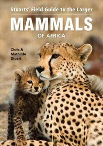
Stuarts` Field Guide To The Larger Mammals Of Africa

Of the more than 5, 500 mammals species worldwide, at least 1, 200 occur in Africa. Stuarts` Field Guide to the Larger Mammals of Africa - a classic and widely acclaimed work - concentrates on the more visible and easily distinguished larger species, as well as some of the more frequently seen smaller mammals. This new edition has been extensively revised, expanded and redesigned and includes: the most recent research and taxonomy; revised distribution maps and many new images; colour-coded grouping of orders; size icons; detailed descriptions of each species, offering insight into key identification characters, typical behaviour, preferred habitat, food choice, reproduction and longevity; whales and dolphins now featured too.
RIP - This product is no longer available on our network. It was last seen on 25.09.2019

This page now acts as a permanent archive for this product. Add more information using the comments box below to ensure it can still be found by future generations.

Use our search facility to see if it is available from an alternative contributor.
  • Availability: Out Of Stock
  • Supplier: Stanfords
  • SKU: 9781775842743
Availability: In Stock
£17.50

Product Description

Of the more than 5, 500 mammals species worldwide, at least 1, 200 occur in Africa. Stuarts` Field Guide to the Larger Mammals of Africa
- a classic & widely acclaimed work
- concentrates on the more visible & easily distinguished larger species, as well as some of the more frequently seen smaller mammals. This new edition has been extensively revised, expanded & redesigned &
Includes:: the most recent research & taxonomy; revised distribution maps & many new images; colour-coded grouping of orders; size icons; detailed descriptions of each species, offering insight into key identification characters, typical behaviour, preferred habitat, food choice, reproduction & longevity; whales & dolphins now featured too.

Reviews/Comments

Add New

Intelligent Comparison

Oooops!
We couldn't find anything!
Perhaps this product's unique.... Or perhaps we are still looking for comparisons!
Click to bump this page and we'll hurry up.

Price History

Vouchers

No voucher codes found.
Do you know a voucher code for this product or supplier? Add it to Insights for others to use.

Facebook

Jargon Buster

Key - A physical or virtual device or code used for opening something
Colour - The categorised spectrum of light visable to humans
Size - is the measurement of how big an object is in space.
Classic - Something that is still like it was originally a high quality standard.
Reproduction - A process of making a copy of something.

Supplier Information

Stanfords
Stanfords was established in 1853 and opened their iconic Covent Garden flagship store in 1901. They have become the top retailer of maps, travel books and accessories in the UK and arguably offer the largest selection of maps and travel books worldwide. Famous names such as Captain Robert Falcon Scott, Ranulph Fiennes and Michael Palin have purchased from Stanfords. They now have a shop in Bristol and both stores together with other venues operate a calendar of events including talks, book signings and exhibitions. As a specialist map retailer, the map selection is comprehensive and includes road maps, street maps and walking maps from worldwide destinations, as well as a selection of world atlases and wall maps. Books include travel guides and travel literature. Stanfords also stock globes, from miniatures made of blue marble to magnificent floor-standing globes. The website features a selection of interesting articles on travel topics.
Page Updated: 2023-11-12 20:15:36

Community Generated Product Tags

Oh No! The productWIKI community hasn't generated any tags for this product yet!
Menu