
 United Kingdom
 France
 Germany
 Netherlands
 Sweden
 USA
USA
 Italy
Italy
 Spain
Spain
More From Contributor


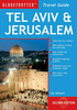
Tel Aviv & Jerusalem
Jerusalem and Tel Aviv on two indexed street plans from New Holland in their Globetrotter series, with enlargements for the Old City and Old Jaffa, plus on the reverse a road map of the central part of Israel.On one side are the street plans. The plan of Jerusalem at 1:14, 000 extends from Mt Scopus and the Hebrew University to Mount Herzl and Yad Vashem. Main museums, public buildings and other places of interest are highlighted, as well as locations of several hotels. The plan provides names of selected streets and does not include some smaller passages and alleyways. The enlargement for the Old City, although large and at 1:4, 000, gives only the outlines of main routes across this densely built up area, without indicating access to the churches and other shrines shown on it.
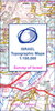
Along the Via Dolorosa Stations of the Cross are marked.Tel Aviv is covered on at 1:14, 700 with similar presentation as the Jerusalem map. Coverage extends from the Diaspora Museum to Old Jaffa, which is also shown on an enlargement at 1:6, 000. Both main street plans are indexed.On the reverse is an indexed road map of central Israel at 1:390, 000, from the northern boundary of the West Bank to the southern tip of the Dead Sea. The map shows the network of main roads, with railway lines also marked. Various places of interest are highlighted. Current political situation in this region is indicated by showing the whole of the West Bank, enclosed by a very approximate boundary and without Jerusalem, as a Palestinian Territory. The separation wall is not marked. Gaza Strip is similarly
presented.
Product Description
Reviews/Comments
Add New
Vouchers
No voucher codes found.
Do you know a voucher code for this product or supplier? Add it to Insights for others to use.
Do you know a voucher code for this product or supplier? Add it to Insights for others to use.
 Denmark