
 United Kingdom
 France
 Germany
 Netherlands
 Sweden
 USA
USA
 Italy
Italy
 Spain
Spain
More From Contributor


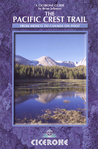
The Pacific Crest Trail
The Pacific Crest Trail is Cicerone’s guide to walking from Mexico to Canada. Brian Johnson provides the information for the 2700 mile route from Mexican-US border town of Campo in South California, through Oregon and Washington, to Manning Park, just over the US-Canadian border. The trail has been purpose built for back-packers and horse-riders and most people undertake the route, or bits of it, in shorter sections at a time, however, every summer several hundred people take on the challenge of thru’-hiking the entire route. Information for bit or thru’ hikers is provided in the guide.The route is described in 101 2-3 day sections with 174 informative section maps and full information about en-route facilities, with schedules for 110 to 180-day thru’-hikes. Full
information on how to use the guide is given. For a sample of how route maps are presented, with altitude cross sections, timings, descriptions, facility and topographical symbols, please see the sample page image provided. The introduction to the guide covers information on things such as weather patterns, plant, wildlife and geology, planning, preparation, wilderness hiking and equipment. Chapters then deal with the PCT as it wends through Southern California, The High Sierra, Northern California, Oregon and Washington. Appendices provide local information for European hikers, useful addresses and a selection of schedules and summaries.
information on how to use the guide is given. For a sample of how route maps are presented, with altitude cross sections, timings, descriptions, facility and topographical symbols, please see the sample page image provided. The introduction to the guide covers information on things such as weather patterns, plant, wildlife and geology, planning, preparation, wilderness hiking and equipment. Chapters then deal with the PCT as it wends through Southern California, The High Sierra, Northern California, Oregon and Washington. Appendices provide local information for European hikers, useful addresses and a selection of schedules and summaries.

Product Description
Reviews/Comments
Add New
Vouchers
No voucher codes found.
Do you know a voucher code for this product or supplier? Add it to Insights for others to use.
Do you know a voucher code for this product or supplier? Add it to Insights for others to use.
 Denmark