More From Contributor

£18.99
The South Downs
- Central at 1:40, 000 in a series of maps printed on waterproof fabric, from Splash Maps, designed for outdoor
...
Archived Product
£7.95
Here is a collection of 20 tried & tested circular walks ranging in length between 2.5 & 8.5 miles. They include crucial dog-walking factors such as livestock, stiles & roads, with warnings in advance when a lead is necessary & when it`s safe for your dog to run free. The routes pass by a number of quintessential English villages, many of which boast welcoming, dog-friendly pubs, along with ancient churches, remote hamlets, stunning views, idyllic cottages, imposing country manor houses & delightful nature reserves. But best of all there`s plenty of places for your dog to run free when walking the Ridgeway. ...
Archived Product
£7.95
The Ridgeway Adventure Atlas, presenting the 87 miles / 139 km long hiking route between the Overton Hill near Avebury to the Ivinghoe Beacon in the Chilterns on mapping at 1:25, 000 in a series of handy A5 size Adventure Atlases from Geographers' A-Z Map Company with cartography from the Ordnance Survey ...
Archived Product
£8.95
The Ridgeway is a National Trail which covers 139km (87 miles) following, in part, an ancient path along the exposed Chiltern Hills escarpment. Starting at Overton Hill near Avebury, The Ridgeway travels northeast, passing near many Neolithic, Iron Age & Bronze Age sites to finish at Ivinghoe Beacon near Tring, Buckinghamshire. This A-Z Adventure Atlas of The Ridgeway features 36 pages of continuous Ordnance Survey mapping providing complete coverage of The Ridgeway Path. This atlas

Includes::
a route planner providing the distances between places & the amenities available, featuring:- Information Centres- Hotels/B& Bs- Youth Hostels- Campsites (seasonal opening)- Restaurants- Public Houses- Cafes (seasonal opening)- Shops- Petrol Stations Also featured is advice on safety & security when walking, details of Tourist Information Centres & a selection of QR codes linked to useful websites. This A-Z Adventure Atlas has the accuracy & quality of OS 1:25000 mapping indexed within a book, making it the perfect companion for walkers, off-road cyclists, horse riders & anyone wishing to explore the great outdoors.

...
Archived Product
£7.95
All the mapping you need to walk the Ridgeway National Trail an 87-mile (139km) route through southern England from Avebury in Wiltshire to Ivinghoe Beacon in Buckinghamshire. Following a ridge of chalk hills through the Chiltern Hills AONB & North Wessex Downs AONB, the Ridgeway is usually completed over 6-8 days & can be walked all year round. ? This booklet of Ordnance Survey 1:25, 000 Explorer maps shows the full line of the National Trail, along with the relevant extract from the OS Explorer map legend. It can be used when walking the trail in either direction, & is just the right size for slipping into a jacket pocket or top of a rucksack. ...
Archived Product
£4.45
Whether you're a walker, a cyclist or a horserider this invaluable guide is full of the practical information you need to plan your visit to the Ridgeway National Trail. It

Includes::
in-depth details about a wide variety of accommodation & facilities such as pubs, shops & attractions that you'll find close to the Trail. It also gives advice about a range of other things including maps, transport & taking your dog with you.

...
Archived Product
£4.95
Whether you`re a walker, a cyclist or a horserider this invaluable guide is full of the practical information you need to plan your visit to the Ridgeway National Trail. It

Includes::
in-depth details about a wide variety of accommodation & facilities such as pubs, shops & attractions that you`ll find close to the Trail. It also gives advice about a range of other things including maps, transport & taking your dog with you.

...
Archived Product
£16.95
This guidebook
- which

Includes::
both a guide to the route & a separate OS map booklet
- describes the


...
Archived Product
£11.99
Practical guide to walking the whole of the Ridgeway National Trail. The Ridgeway path begins near Avebury & runs 87 miles across the high chalk downs of Wiltshire, into the Thames Valley & on to the Chiltern Hills of Buckinghamshire, finishing at Ivinghoe Beacon near Aylesbury.
Includes:: Ridgeway map, 53 large-scale maps (1:20, 000), guides to 24 towns & villages. Detailed accommodation: campsites, B& Bs, hotels, hostels & bunkhouses. Places to eat: cafes, teashops, pubs & restaurants. Detailed public transport information. Itineraries for all walkers including day Ridgeway walks. Downloadable GPS waypoints. Colour pictures including 4 paqe flower & butterfly guide.
...
Archived Product

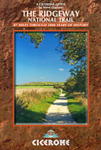
The Ridgeway National Trail

Steve Davison’s Cicerone guide to the Ridgeway National Trail will help you enjoy the 139km (87 miles) most historic walking route, from Avebury to Ivinghoe Beacon. It will lead you through two Areas of Outstanding Natural Beauty: the chalky North Wessex Downs and the wooded Chiltern Hills. This is an ideal guide for day trips as well as long-distance walks.Follow the tracks, some of which are over 5000 years old, and discover the extraordinary sights including the UNESCO World Heritage Sites of Avebury’s Neolithic stone circle and the famous Uffington White Horse. Visit Iron Age hill forts, stop by picturesque towns and villages and watch the rich local wildlife.The guide organises the trail in 12 short stages west to east, but also provides details for walking it in the opposite
direction, east to west. This way you can plan how far you would like to walk each day, whether you are going to do it over a week or going to do one or two stages at a time. The trail is well waymarked, and by not exceeding 300m passes over comparatively gentle terrain. Detailed route descriptions are accompanied by Ordnance Survey extracts mapping the route ahead, as well as colour photographs illustrating some of the highlights of the region.The guide includes information on historic sites, details of excursions to nearby towns and villages, accommodation and useful contacts.
RIP - This product is no longer available on our network. It was last seen on 25.09.2019

This page now acts as a permanent archive for this product. Add more information using the comments box below to ensure it can still be found by future generations.

Use our search facility to see if it is available from an alternative contributor.
  • Availability: Out Of Stock
  • Supplier: Stanfords
  • SKU: 9781852846947
Availability: In Stock
£12.95

Product Description

Steve Davison’s Cicerone guide to the Ridgeway National Trail will help you enjoy the 139km (87 miles) most historic walking route, from Avebury to Ivinghoe Beacon. It will lead you through two Areas of Outstanding Natural Beauty: the chalky North Wessex Downs & the wooded Chiltern Hills. This is an ideal guide for day trips as well as long-distance walks. Follow the tracks, some of which are over 5000 years old, & discover the extraordinary sights including the UNESCO World Heritage Sites of Avebury’s Neolithic stone circle & the famous Uffington White Horse. Visit Iron Age hill forts, stop by picturesque towns & villages & watch the rich local wildlife. The guide organises the trail in 12 short stages west to east, but also provides details for walking it in the opposite direction, east to west. This way you can plan how far you would like to walk each day, whether you are going to do it over a week or going to do one or two stages at a time. The trail is well waymarked, & by not exceeding 300m passes over comparatively gentle terrain. Detailed route descriptions are accompanied by Ordnance Survey extracts mapping the route ahead, as well as colour photographs illustrating some of the highlights of the region. The guide

Includes::
information on historic sites, details of excursions to nearby towns & villages, accommodation & useful contacts.

Reviews/Comments

Add New

Intelligent Comparison

Oooops!
We couldn't find anything!
Perhaps this product's unique.... Or perhaps we are still looking for comparisons!
Click to bump this page and we'll hurry up.

Price History

Vouchers

No voucher codes found.
Do you know a voucher code for this product or supplier? Add it to Insights for others to use.

Facebook

Jargon Buster

White - A colour combining all colours
Watch - A small clock designed to be worn on a person
iron - An electrical deviced used for removing creases from fabrics
iron - A chemical element (FE). The most common element on earth
World - A physical grouping, commonly used to describe earth and everything associated with ti
Stone - Or Rock is a naturally occuring mineral categorised into three types, Igneous, Sedimentary and Metamorphic
Colour - The categorised spectrum of light visable to humans
Day - The time it takes a planet or other space objects to complete one rotation.
Natural - not manmade
Horse - A large animal with four legs that tends to be ridden.
Accommodation - A room in which someone can live in, for example in a hotel
Ideal - Something that satisfies a perfect criteria.

Supplier Information

Stanfords
Stanfords was established in 1853 and opened their iconic Covent Garden flagship store in 1901. They have become the top retailer of maps, travel books and accessories in the UK and arguably offer the largest selection of maps and travel books worldwide. Famous names such as Captain Robert Falcon Scott, Ranulph Fiennes and Michael Palin have purchased from Stanfords. They now have a shop in Bristol and both stores together with other venues operate a calendar of events including talks, book signings and exhibitions. As a specialist map retailer, the map selection is comprehensive and includes road maps, street maps and walking maps from worldwide destinations, as well as a selection of world atlases and wall maps. Books include travel guides and travel literature. Stanfords also stock globes, from miniatures made of blue marble to magnificent floor-standing globes. The website features a selection of interesting articles on travel topics.
Page Updated: 2023-11-12 20:15:36

Community Generated Product Tags

Oh No! The productWIKI community hasn't generated any tags for this product yet!
Menu