More From Contributor

£16.99
Titanic Reference Wall Map from the National Geographic, paper version – size 99 x 66cm (39” x 26”), presenting on one side a map of the Atlantic annotated with shipping routes, sea currents, iceberg lines, etc, plus very extensive text on all aspects relating to the sinking of the ship; on the reverse is more information about the ship itself plus notes about the lost & the saved, the legacy of the disaster, & more. On one side the map shows the route of the Titanic from Southampton, via Cherbourg in France & Queenstown (now Cobh) in Irel&, to the point where the ship issued its distress signal, together with shipping lanes before & after 1913, as well as sights of notable shipwrecks & landmarks. On l&, on both sides of the Atlantic, the map shows locations of various institutions & memorials connected with the Titanic. The map of the Atlantic is surrounded by several panels providing further information: Icebergs, Shipping News, Women & Children First, In Memoriam, & The Wreck Discovered – illustrated with a more detailed map of the area & colour photos. Also included is a graph showing iceberg frequency, a table with a breakdown of losses among passengers & the crew of the ship, time chart from commissioning the design of the Titanic to the death of the last survivor in 2009, etc. On the reverse, are detailed drawings of the ship’s decks & the ships’ profile, information about selected victims & survivors, comparisons of its size with other famous ships & buildings, a list of films, plays & documentaries inspired by the disaster, etc. This map is also available encapsulated & in a folded format. ...
Archived Product
£8.99
This guide is a wonderful addition to Conway`s best-selling pocket book series that examines this famous ship from a refreshingly different angle. Launched in May 1911, the triple-screw steamer Titanic was the pride of the White Star Line & at that time the largest passenger ship in the world. Built to carry passengers in comfort & luxury on the lucrative transatlantic route, her design, fittings & on board facilites epitomised the spirit of the age in terms of elegance & style. Titanic: A Passenger`s Guide is a unique guide to all aspects of the ship, incorporating authentic period literature
- from sources including White Star Line themselves, Harland & Wolff shipyards, & important publications from the time.
...
Archived Product
£9.99
Just in time for the centennial of the sinking of the Titanic, this graphic deluxe edition compiles firsthand accounts, testimonies, & letters by notable Titanic survivors, including Archibald Gracie, Lawrence Beesley, Elizabeth W. Shutes, & the ”unsinkable” Molly Brown. Full of historically accurate details & an afterword by the grandson of Lawrence Beesley, Titanic Survivors & author of ” The Loss of the S.S. Titanic”, it will be the gift to give die-hard Titanic buffs. Authoritative, commemorative & in a striking, luxurious package with & introduction by Titanic enthusiast & expert, Tim Maltin, this will be the authoritative work on the disaster. ...
Archived Product
£8.99
At 2.20am on 15th April 1912, the Titanic was plunging 12, 000 feet to the ocean floor. Machinery, coal, crystal goblets, pianos & jewellery all tumble through the dark water. Hundreds of passengers & crew remain trapped below decks
- hundreds more will perish on the surface. This is the definitive chronology of the Titanic`s final hours, told in fascinating detail & offering a real-time experience of one of the greatest dramas of twentieth century history.
...
Archived Product
£20.00
It was hailed as ”unsinkable”, the biggest ship in the world, the ultimate in seafaring luxury. Yet within five days of setting ...
Archived Product
£10.50
Map No. 893, Titisee-Neustadt, printed on sturdy, waterporrf & tear-resistant plastic paper in a series of hiking maps from Kompass providing extensive coverage of Austria & Germany plus the Slovenian Alps, with hiking routes on a topographic base, various types of accommodation, recreational facilities, places of interest, etc. Many titles are now published as competitively priced sets of two or more maps, offering a wider coverage. Kompass are Europe ...
Archived Product
£9.99
One of the titles in a series of double-sided topographic maps with hiking routes & tourist information. Cartography is identical to the standard topographic survey of Germany, with contours at 10m intervals. Extensive overprint highlights numerous local footpaths & long-distance hiking routes, indicating waymarking. Cycling routes, mountain bike centres & trails, & cross-country ski routes are also marked. Extensive range of symbols highlight sport & leisure facilities, various types of accommodation, places of interest, tourist railways, etc. Boundaries of national parks & nature reserves are marked. The maps have a 2km UTM grid. Map legend

Includes::
English. The maps also have lists of contact details of various organizations & facilities within the region, plus brief descriptions in German only.

...
Archived Product
£13.99
Titisee-Neustadt (No. 893), a detailed, GPS compatible map at 1:25, 000 from Kompass with local & long-distance footpaths, cycling routes, accommodation, etc, printed on durable, waterproof & tear-resistant synthetic paper. KOMPASS HIKING & RECREATIONAL MAPS: This title is part of an extensive series covering Austria, much of Germany & the Slovenian Alps. Kompass are Europe’s largest publishers of hiking maps; their mapping of other countries, including expanding coverage of Italy, is listed on our website separately.CARTOGRAPHY: The maps are contoured with additional shading, graphic relief & colouring to provide a more detailed picture of the terrain, vegetation and/or land use. Contour interval varies from 10m in the coastal areas of Northern Germany to 40 or 50 metres in the mountainous regions. All the maps highlight local & long-distance waymarked footpaths, including climbing trails. Most titles also show cycling routes, mountain bike trails, &, the in mountainous areas, ski routes. The maps indicate various types of accommodation (selected inns & hotels, youth hostels, campsites, mountain refuges), as well as recreational facilities, places of interest, etc. Latest editions also show access by public transport with bus stops and/or Park+ Ride facilities.GEOGRAPHICAL COORDINATES: Unless indicated to the contrary in the individual description, the maps have a UTM grid for GPS users. MAP LEGEND: Most maps now include full English legend, particularly titles covering the Alpine areas. Some maps covering mainly eastern Austria or the less popular parts of Germany may still have a legend in German only.OTHER
Features: Selected titles include on the reverse panorama drawings of their area with names of villages, peaks, valleys, etc. and/or have a booklet with pictures of local wild flowers with their Latin names. Many titles are now published as competitively priced sets of two or more maps, offering a wider coverage.BOOKLETS: PLEASE NOTE BEFORE ORDERING! Many titles come with a booklet describing the area and/or various hiking routes. Unless indicated in the individual description that the booklet

Includes::
English, these booklets are IN GERMAN only. The booklets are not necessary to use the maps since, as stated above, full English language map legend is provided.


...
Archived Product
£8.95
Map No. 893, Titisee-Neustadt, in a series of hiking maps from Kompass providing extensive coverage of Austria & Germany plus the Slovenian Alps, with hiking routes on a topographic base, various types of accommodation, recreational facilities, places of interest, etc. Many titles are now published as competitively priced sets of two or more maps, offering a wider coverage. Kompass are Europe ...
Archived Product
£12.99
Titlis
- Hasliberg
- Melchsee-Frutt
- Engelberg area of central Switzerland at 1:33, 333 on light, waterproof & tear-resistant


...
Archived Product

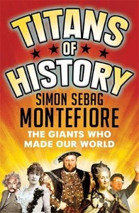
Titans Of History: The Giants Who Made Our World

NEW EDITION - FEATURING UPDATED INTRODUCTION AND NEW CHAPTERS The giant characters of history - from Mozart to Michelangelo, Shakespeare to Einstein, Henry VIII to Hitler, Catherine the Great to Margaret Thatcher, Jesus Christ to Genghis Khan -- lived lives of astonishing drama and adventure, debauchery and slaughter, but they also formed our world and will shape our future. In this eclectic and surprising collection of short and entertaining life stories, Simon Sebag Montefiore introduces his choice of kings, empresses, sultans and conquerors, as well as prophets, explorers, artists, actresses, courtesans and psychopaths. From the ancient times, via crusades and world wars, up to the 21st century, this accessible history introduces readers to the titans who changed the
world: the characters we should all know, and the stories we should never forget.
RIP - This product is no longer available on our network. It was last seen on 25.09.2019

This page now acts as a permanent archive for this product. Add more information using the comments box below to ensure it can still be found by future generations.

Use our search facility to see if it is available from an alternative contributor.
  • Availability: Out Of Stock
  • Supplier: Stanfords
  • SKU: 9781474606462
Availability: In Stock
£12.99

Product Description

NEW EDITION
- FEATURING UPDATED INTRODUCTION & NEW CHAPTERS The giant characters of history
- from Mozart to Michelangelo, Shakespeare to Einstein, Henry VIII to Hitler, Catherine the Great to Margaret Thatcher, Jesus Christ to Genghis Khan -- lived lives of astonishing drama & adventure, debauchery & slaughter, but they also formed our world & will shape our future. In this eclectic & surprising collection of short & entertaining life stories, Simon Sebag Montefiore introduces his choice of kings, empresses, sultans & conquerors, as well as prophets, explorers, artists, actresses, courtesans & psychopaths. From the ancient times, via crusades & world wars, up to the 21st century, this accessible history introduces readers to the titans who changed the world: the characters we should all know, & the stories we should never forget.

Reviews/Comments

Add New

Intelligent Comparison

Oooops!
We couldn't find anything!
Perhaps this product's unique.... Or perhaps we are still looking for comparisons!
Click to bump this page and we'll hurry up.

Price History

Vouchers

No voucher codes found.
Do you know a voucher code for this product or supplier? Add it to Insights for others to use.

Facebook

Jargon Buster

History - Anything that happens in the past. An acedemic subject.
World - A physical grouping, commonly used to describe earth and everything associated with ti
Adventure - an undertaking of an exciting challenge or experience.

Supplier Information

Stanfords
Stanfords was established in 1853 and opened their iconic Covent Garden flagship store in 1901. They have become the top retailer of maps, travel books and accessories in the UK and arguably offer the largest selection of maps and travel books worldwide. Famous names such as Captain Robert Falcon Scott, Ranulph Fiennes and Michael Palin have purchased from Stanfords. They now have a shop in Bristol and both stores together with other venues operate a calendar of events including talks, book signings and exhibitions. As a specialist map retailer, the map selection is comprehensive and includes road maps, street maps and walking maps from worldwide destinations, as well as a selection of world atlases and wall maps. Books include travel guides and travel literature. Stanfords also stock globes, from miniatures made of blue marble to magnificent floor-standing globes. The website features a selection of interesting articles on travel topics.
Page Updated: 2023-11-12 20:15:36

Community Generated Product Tags

Oh No! The productWIKI community hasn't generated any tags for this product yet!
Menu