
 United Kingdom
 France
 Germany
 Netherlands
 Sweden
 USA
USA
 Italy
Italy
 Spain
Spain
More From Contributor
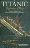
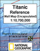

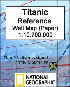
Titanic Reference NGS Wall Map PAPER
Titanic Reference Wall Map from the National Geographic, paper version – size 99 x 66cm (39” x 26”), presenting on one side a map of the Atlantic annotated with shipping routes, sea currents, iceberg lines, etc, plus very extensive text on all aspects relating to the sinking of the ship; on the reverse is more information about the ship itself plus notes about the lost and the saved, the legacy of the disaster, and more.On one side the map shows the route of the Titanic from Southampton, via Cherbourg in France and Queenstown (now Cobh) in Ireland, to the point where the ship issued its distress signal, together with shipping lanes before and after 1913, as well as sights of notable shipwrecks and landmarks. On land, on both sides of the Atlantic, the map shows
locations of various institutions and memorials connected with the Titanic. The map of the Atlantic is surrounded by several panels providing further information: Icebergs, Shipping News, Women and Children First, In Memoriam, and The Wreck Discovered – illustrated with a more detailed map of the area and colour photos. Also included is a graph showing iceberg frequency, a table with a breakdown of losses among passengers and the crew of the ship, time chart from commissioning the design of the Titanic to the death of the last survivor in 2009, etc.On the reverse, are detailed drawings of the ship’s decks and the ships’ profile, information about selected victims and survivors, comparisons of its size with other famous ships and buildings, a list of films, plays and
documentaries inspired by the disaster, etc.This map is also available encapsulated and in a folded format.

Product Description
Reviews/Comments
Add New
Vouchers
No voucher codes found.
Do you know a voucher code for this product or supplier? Add it to Insights for others to use.
Do you know a voucher code for this product or supplier? Add it to Insights for others to use.
 Denmark