
 United Kingdom
 France
 Germany
 Netherlands
 Sweden
 USA
USA
 Italy
Italy
 Spain
Spain
More From Contributor


Waterways Of Britain - The Times
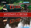
Highly illustrated hardback book of the navigable waterways of Britain. It is packed with maps of the canals and photographs of scenes along the waterways. Regarded as the 'quickest way of slowing down', the canals and rivers of Britain evoke a bygone era when life moved at a more leisurely pace. Founded on the careful selection of a variety of significant navigations, The Times Waterways of Britain offers a well-rounded view of the contemporary inland waterways system.This picture is built up by delving into their historical past, by a close examination of the present scene, together with a forward glance towards future directions and development. Focusing on some of the many disparate strands of the fabric that go to make up our inland waterways, this book sets the evolution of the
canals and navigable rivers against the social, economic and industrial backdrop of their time.Features a timeline of important waterway developments from early beginnings through to the present day - with a look towards the future. Offers an insight into the sometimes hidden wealth of waterway features and heritage. Illustrated with mapping, archive and over 300 contemporary photographs. Facts and figures for selected waterways. Highlights cities, towns and places of interest. Introduces the diverse wildlife to be found along the waterways.
canals and navigable rivers against the social, economic and industrial backdrop of their time.Features a timeline of important waterway developments from early beginnings through to the present day - with a look towards the future. Offers an insight into the sometimes hidden wealth of waterway features and heritage. Illustrated with mapping, archive and over 300 contemporary photographs. Facts and figures for selected waterways. Highlights cities, towns and places of interest. Introduces the diverse wildlife to be found along the waterways.
Product Description
Reviews/Comments
Add New
Vouchers
No voucher codes found.
Do you know a voucher code for this product or supplier? Add it to Insights for others to use.
Do you know a voucher code for this product or supplier? Add it to Insights for others to use.
 Denmark