More From Contributor

£16.99
Severn, Avon & Birmingham Waterways Guide published by Collins under their Nicholson imprint in a series of spiral-bound guides to Britain’s inland waterways. Coverage

Includes::
River Avon, Birmingham Canal Navigations, Droitwitch Canals, Gloucester & Sharpness Canal & the Severn, Staffordshire & Worcestershire Canal, Stourbridge & Dudley Canals, Stratford-on-Avon Canal, & Worcester & Birmingham Canal. Guides in the Nicholson series have Ordnance Survey’s mapping from the Landranger series with an overprint highlighting the waterways & adding locks with their names, number & rise, also staircase locks, weirs, turning points, various facilities such as overnight moorings, water points, sewage & refuse disposal, food shops, public houses & restaurants, etc. Towpaths, which can also be used by hikers or cyclists, are clearly marked. The guides provide descriptions of towns & villages, contact details & where appropriate opening hours of local services, etc. Each guide also

Includes::
an introductory section with general advice, regulations & tips. Completing the series is a general map of Great Britain showing the country’s navigable waterways.


...
Archived Product
£16.99
The number 1 choice for all users of the inland waterways. This established, popular & practical guide covers the canals & waterways in Wales & to the south of Liverpool. Covered in this guide are: Caldon & Leek Canals, Llangollen Canal, Monmouthshire & Brecon Canal, Neath & Tennant & Swansea Canals, Montgomery Canal, Shropshire Union Canal, Staffordshire & Worcestershire Canal, Trent & Mersey Canal, River Weaver. The detailed Ordnance Survey (R) maps clearly show the location of essential features such as locks, towpaths & boating facilities, as well as pubs, shops & restaurants in the area. There are comprehensive navigational notes & descriptive text on the history of each canal, & on local services & places of interest, for which postcodes are included
- ideal to be used with sat-navs. This practical A5 guide features `lie flat` spiral binding & `book mark` back cover flap for ease of reference. In print for over 40 years, the Collins/ Nicholson guides to the waterways have always been a vital part of journeys along Britain`s canals & rivers. These bestselling guides are designed for anyone & everyone with an interest in Britain`s inland waterways
- from experienced boaters to those planning their first boat trip, as well as walkers, cyclists & visitors. Nicholson`s
- The bestselling guides to Britain`s Waterways.


...
Archived Product
£16.99
The number 1 choice for all users of the inland waterways. This established, popular & practical guide covers the canals & waterways between Exeter & the River Thames. Waterways covered in this guide
- Basingstoke Canal, Bridgwater & Taunton Canal, Grand Western Canal, Exeter Ship Canal, Kennet & Avon Canal, River Thames, Wey & Godalming Navigations. The detailed Ordnance Survey (R) maps clearly show the location of essential features such as locks, towpaths & boating facilities, as well as pubs, shops & restaurants in the area. There are comprehensive navigational notes & descriptive text on the history of each canal, & on local services & places of interest, for which postcodes are included
- ideal to be used with sat-navs. This practical A5 guide features `lie flat` spiral binding & `book mark` back cover flap for ease of reference. In print for over 40 years, the Collins/ Nicholson guides to the waterways have always been a vital part of journeys along Britain`s canals & rivers. These bestselling guides are designed for anyone & everyone with an interest in Britain`s inland waterways
- from experienced boaters to those planning their first boat trip, as well as walkers, cyclists & visitors.


...
Archived Product
£30.00
Highly illustrated hardback book of the navigable waterways of Britain. It is packed with maps of the canals & photographs of scenes along the waterways. Regarded as the 'quickest way of slowing down', the canals & rivers of Britain evoke a bygone era when life moved at a more leisurely pace. Founded on the careful selection of a variety of significant navigations, The Times Waterways of Britain offers a well-rounded view of the contemporary inland waterways system. This picture is built up by delving into their historical past, by a close examination of the present scene, together with a forward glance towards future directions & development. Focusing on some of the many disparate strands of the fabric that go to make up our inland waterways, this book sets the evolution of the canals & navigable rivers against the social, economic & industrial backdrop of their time. Features a timeline of important waterway developments from early beginnings through to the present day
- with a look towards the future. Offers an insight into the sometimes hidden wealth of waterway features & heritage. Illustrated with mapping, archive & over 300 contemporary photographs. Facts & figures for selected waterways. Highlights cities, towns & places of interest. Introduces the diverse wildlife to be found along the waterways.
...
Archived Product
£16.99
Exploring Britain`s most beautiful waterways. Discover a hidden countryside which is packed with wildlife along with industrial heritage. Regarded as the `quickest way of slowing down`, the canals & rivers of Britain evoke a bygone era when life moved at a more leisurely pace. A selection of Britain`s main navigation`s are shown. Waterways of Britain offers a well-rounded view of the contemporary inland waterways system. This picture is built up by delving into their historical past, by a close examination of the present scene, together with a forward glance towards future directions & development. * Features a timeline of important waterway developments from early beginnings through to the present day
- with a look towards the future. * Offers an insight into the sometimes hidden wealth of waterway features & heritage. * Illustrated with mapping & over 300 contemporary photographs. * Facts & figures for selected waterways. * Introduces the diverse wildlife to be found along the waterways. Originally published in hardback as The Times Waterways of Britain (2010).
...
Archived Product
£14.99
A bestseller in hardback, this beautiful celebration of Britain`s rich waterways heritage is now available in paperback for the first time. Through the superb photography of Derek Pratt, this lovely & quirky book looks at 50 transitional years when Britain`s inland waterways changed from being a thriving commercial transport system to the much-loved pleasure cruising network it is today. Each double page spread juxtaposes superb atmospheric black & white photos of the locations as they were 50 years ago with vibrant colour photos showing how they look today, with many new photographs & updated captions for this edition. From quintessentially English rivers to London`s busy canal network, this wonderful book highlights the architectural legacy & natural beauty that attracts thousands of visitors to go boating or walking along the towpaths. ...
Archived Product
£14.99
This is a collection of archive photos of the English canal system at the start of the 20th century, & a clear visual record of the working lives of the people who worked on the system at the end of the Victorian era. Drawn mostly from the archives of the British Waterways Board, most of these photos have never before been published. ...
Archived Product
£3.50
Street by Street Watford Midi has been fully updated with a stylish new cover design, in a handy glovebox size. Quick to navigate & easy-to-use, the maps clearly show AA recommended restaurants, pubs, hotels, one-way streets & car parks. Featuring a clever use of colour to ensure it can be read under street lighting, & National Grid referencing, Street by Street Watford Midi is all you need to keep you on the move. ...
Archived Product
£2.75
Black & white street plan covering Watford, Leavesden Green & Kingswood at Approx. 1:10, 000 scale, & on the reverse shows Watford, Bushey & Oxhey together at Approx. 1:32, 000 scale. Each map shows grid squares every half-mile &

Includes::
street indexes. Shows some landmarks, public buildings such as schools, railway stations & police stations, & some notable private buildings & inns.

...
Archived Product
£3.50
Watford in 1896 in a fascinating series of reproductions of old Ordnance Survey plans in the Alan Godfrey Editions, ideal for anyone interested in the history of their neighbourhood or family. The map is double-sided, to give maximum coverage of the town. The main map covers the town centre, extending westward to Foxholes, & northward to Butts Close. Features include St Mary`s church, The Priory, Windmill Hill, The Grove, Holy Saviour`s church, Whinbush Grove, Lavender Distillery, Leather Dressing Works, engine shed, Market Place, High Street, Rosenburg, Infirmary, Workhouse, cemetery, etc. On the reverse is a portion of adjacent sheet 12.02 extending coverage eastward to include the station. About the Alan Godfrey Editions of the 25” OS Series: Selected towns in Great Britain & Ireland are covered by maps showing the extent of urban development in the last decades of the 19th & early 20th century. The plans have been taken from the Ordnance Survey mapping & reprinted at about 15 inches to one mile (1:4, 340). On the reverse most maps have historical notes & many also include extracts from contemporary directories. Most maps cover about one mile (1.6kms) north/south, one & a half miles (2.4kms) across; adjoining sheets can be combined to provide wider coverage.FOR MORE INFORMATION & A COMPLETE LIST OF ALL AVAILABLE TITLES PLEASE CLICK ON THE SERIES LINK. ...
Archived Product

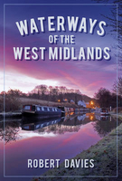
Waterways Of The West Midlands

This enjoyable new book delves into unexplored areas of history surrounding the great network of the West Midland Canals. It provides a new insight into its most fascinating figures and places, including interviews with some of the last true boatmen, whose world disappeared forever during the turbulent 1960s. It reveals fascinating figures like John Corbett, who became one of the richest men in Britain during the 19th century, through salt and canals. He built a fabulous chateau for his unfaithful wife on the outskirts of Droitwich that can still be visited today. We also have an account of how the Droitwich Canals have been wonderfully restored to the navigation system, with old and new photographs depicting the changes. And not forgetting such pivotal characters such as Boulton and
Watt, who were an essential part of the canal story. We at The History Press are sure that this book will appeal to canal enthusiasts and all who love the West Midlands with its amazing Waterways.
RIP - This product is no longer available on our network. It was last seen on 25.09.2019

This page now acts as a permanent archive for this product. Add more information using the comments box below to ensure it can still be found by future generations.

Use our search facility to see if it is available from an alternative contributor.
  • Availability: Out Of Stock
  • Supplier: Stanfords
  • SKU: 9780750960045
Availability: In Stock
£14.99

Product Description

This enjoyable new book delves into unexplored areas of history surrounding the great network of the West Midland Canals. It provides a new insight into its most fascinating figures & places, including interviews with some of the last true boatmen, whose world disappeared forever during the turbulent 1960s. It reveals fascinating figures like John Corbett, who became one of the richest men in Britain during the 19th century, through salt & canals. He built a fabulous chateau for his unfaithful wife on the outskirts of Droitwich that can still be visited today. We also have an account of how the Droitwich Canals have been wonderfully restored to the navigation system, with old & new photographs depicting the changes. & not forgetting such pivotal characters such as Boulton & Watt, who were an essential part of the canal story. We at The History Press are sure that this book will appeal to canal enthusiasts & all who love the West Midlands with its amazing Waterways.

Reviews/Comments

Add New

Intelligent Comparison

Oooops!
We couldn't find anything!
Perhaps this product's unique.... Or perhaps we are still looking for comparisons!
Click to bump this page and we'll hurry up.

Price History

Vouchers

No voucher codes found.
Do you know a voucher code for this product or supplier? Add it to Insights for others to use.

Facebook

Jargon Buster

History - Anything that happens in the past. An acedemic subject.
World - A physical grouping, commonly used to describe earth and everything associated with ti
Watt - A unit of measure for power
Love - Someone who shows deep affection for someone else.
Network - A link and communication between things. Often computers or people.

Supplier Information

Stanfords
Stanfords was established in 1853 and opened their iconic Covent Garden flagship store in 1901. They have become the top retailer of maps, travel books and accessories in the UK and arguably offer the largest selection of maps and travel books worldwide. Famous names such as Captain Robert Falcon Scott, Ranulph Fiennes and Michael Palin have purchased from Stanfords. They now have a shop in Bristol and both stores together with other venues operate a calendar of events including talks, book signings and exhibitions. As a specialist map retailer, the map selection is comprehensive and includes road maps, street maps and walking maps from worldwide destinations, as well as a selection of world atlases and wall maps. Books include travel guides and travel literature. Stanfords also stock globes, from miniatures made of blue marble to magnificent floor-standing globes. The website features a selection of interesting articles on travel topics.
Page Updated: 2023-11-12 20:15:36

Community Generated Product Tags

Oh No! The productWIKI community hasn't generated any tags for this product yet!
Menu