
 United Kingdom
 France
 Germany
 Netherlands
 Sweden
 USA
USA
 Italy
Italy
 Spain
Spain
More From Contributor


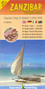


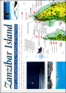
Zanzibar Island
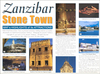
Zanzibar and the surrounding islands in the publisher’s characteristic hand-drawn style - more of a guide than just a map! Zanzibar is shown with its road network (petrol stations are marked) and vegetation, annotated with numerous places of interest, accommodation, leven banks, diving and snorkelling sites, etc.On the reverse a series of panels provide notes on everything from the island’s history and geography to marine life, Colobus monkeys, Coconut crabs, game fishing, seaweed farming, boat carpentry, witchcraft and ghosts, etc. The map is illustrated with colour photo and beautiful drawings.

Product Description
Reviews/Comments
Add New
Vouchers
No voucher codes found.
Do you know a voucher code for this product or supplier? Add it to Insights for others to use.
Do you know a voucher code for this product or supplier? Add it to Insights for others to use.
 Denmark