
 United Kingdom
 France
 Germany
 Netherlands
 Sweden
 USA
USA
 Italy
Italy
 Spain
Spain
More From Contributor


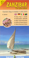
Zanzibar - The Spice Island
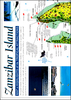
Zanzibar on a detailed, contoured map from Harms Verlag, specialist in providing excellent mapping of various parts of mainland Tanzania. The map includes insets showing Pemba Island and Zanzibar Town (both the Stone Town and the Ng’ambo district). Contours are shown at 10m intervals and the map indicates several types of vegetation on the island, from rice and sugar cane fields and other cultivated land to mangroves, forests, grassland, etc. Overprint highlights hotels and lodges, beaches, sailing and surfing areas, diving sites, etc. The map has a UTM grid at intervals of 8km (more sensible than it sounds - dividing lengths visually by eight is far easier than by ten), with latitude and longitude shown by margin ticks at intervals of 1`. Map legend includes English.A
separate inset shows Pemba Island at 1:250, 000. The map also includes a plan of Zanzibar Town (both the Stone Town and the Ng’ambo district) highlighting hotels, eating places and other facilities. On the reverse is general information about Zanzibar in English, German and Italian.
separate inset shows Pemba Island at 1:250, 000. The map also includes a plan of Zanzibar Town (both the Stone Town and the Ng’ambo district) highlighting hotels, eating places and other facilities. On the reverse is general information about Zanzibar in English, German and Italian.

Product Description
Reviews/Comments
Add New
Vouchers
No voucher codes found.
Do you know a voucher code for this product or supplier? Add it to Insights for others to use.
Do you know a voucher code for this product or supplier? Add it to Insights for others to use.
 Denmark