
 United Kingdom
 France
 Germany
 Netherlands
 Sweden
 USA
USA
 Italy
Italy
 Spain
Spain
More From Contributor


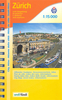

Zurich Pocket Plan
Pocket street plan of Zurich at 1:17, 500 from Orell Füssli’s range of street plans of Swiss cities, providing coverage of the central section across the city and its suburbs, from Wollishofen on Lake Zurich across to the international airport at Kloten, but with only limited coverage of the western and eastern districts.Tram and bus routes are shown with line numbers and stops, and on an enlargement for the city centre at 1:10, 000 one way streets are also marked. On some longer streets selected house numbers are indicated. The map is indexed and includes brief notes and a list of useful phone numbers. Map legend and the text include English.Unfortunately some of the street names are difficult to read, particularly on the enlargement for the city centre, almost obliterated by
symbols highlighting various places of interest. Better know for its gnomes and bankers, Zurich is apparently full of night clubs!
symbols highlighting various places of interest. Better know for its gnomes and bankers, Zurich is apparently full of night clubs!

Product Description
Reviews/Comments
Add New
Vouchers
No voucher codes found.
Do you know a voucher code for this product or supplier? Add it to Insights for others to use.
Do you know a voucher code for this product or supplier? Add it to Insights for others to use.
 Denmark