
 United Kingdom
 France
 Germany
 Netherlands
 Sweden
 USA
USA
 Italy
Italy
 Spain
Spain
More From Contributor


Zurich
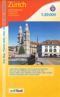
Street plan of the whole of Zurich with the outlying suburbs in Orell Füssli’s range of street plans of Swiss cities. Coverage extends from the international airport at Kloten to Kilchberg and Küsnacht on Lake Zurich, and from Geroldswil and Dietikon in the west to Volketswil in the east. The city centre is shown enlarged at 1:10, 000. Both plans show public transport network, with tram and bus routes with stops and line numbers, plus ferry connections on Lake Zurich. The city centre plan also indicates one way streets. On some longer streets selected house numbers are indicated. Symbols highlight Park+Ride facilities, coach and car parks, churches and religious building of various denominations, museums, theatres and other cultural centres, shooting ranges, etc. Extensive
index on the reverse of the map has separate lists for satellite suburbs and villages. Also included is large, clear and easy to follow diagram of all the public transport routes, including railway lines and ferry routes.
index on the reverse of the map has separate lists for satellite suburbs and villages. Also included is large, clear and easy to follow diagram of all the public transport routes, including railway lines and ferry routes.

Product Description
Reviews/Comments
Add New
Vouchers
No voucher codes found.
Do you know a voucher code for this product or supplier? Add it to Insights for others to use.
Do you know a voucher code for this product or supplier? Add it to Insights for others to use.
 Denmark