More From Contributor

£27.00
The Garmin Auto Nav Kit contains all that you need to maximise the full functionality of your Dakota, Oregon or Colorados GPS turn-by-turn directions. It

Includes::
a bracket for windscreen mounting, a dashboard disk & a 12V Adaptor to power the unit from the cars auxiliary power socket. Compatible devices: Colorado 300 Dakota 10
- 20 Etrex 10
- 20
- 30 GPS MAP 62
- 62S - SC
- ST
- STC
- 64
- 64S
- 64ST Oregon 200
- 300
- 400
- 400T
- 450
- 450T
- 550
- 550T
- 600
- 600T
- 650
- 650T  


...
Archived Product
£12.60
This Bike Mount is a simple device to attach a wide range of Garmin GPS devices to your bike. The sturdy mount can be attached to either the stem or handlebars of the bike using cable ties to make it easy to read the display whilst cycling. From our experience mounting on the stem is the best option as it keeps your bars clutter free. The clip on the back of the GPS device slides into the mount for a secure fitting that will withstand off-road riding. Compatible with: Approach G3
- G5 Colorado 300 Dakota 10
- 20 Etrex 10
- 20
- 30 GPS MAP 62
- 62S - SC
- ST
- STC
- 64
- 64S
- 64ST Oregon 200
- 300
- 400
- 400T
- 450
- 450T
- 550
- 550T
- 600
- 600T
- 650
- 650T  


...
Archived Product
£89.10
The e Trex made better by the masters of handheld GPS. The new e Trex 10 retains the core functionality, rugged construction, affordability & long battery life that made e Trex the most dependable GPS device available. enhanced user interface, a worldwide basemap, paperless geocaching & added support for mounting accessories. e Trex 10 has an enhanced 2.2 inch monochrome display that’s easy to read in any lighting situation. Both durable & waterproof the e Trex 10 features the legendary toughness that’s built to withstand the elements – be it dust, dirt, humidity or water. This brilliant little GPS unit features paperless geocaching by supporting GPX files for downloading geocaches & details straight to your unit. Visit Open Caching.com to start your geocaching adventure. By going paperless, youre not only helping the environment but also making your geocaching more fun. e Trex 10 stores & displays all the information you need, including location, terrain, difficulty, hints & descriptions, which means no more manually entering coordinates & carrying around paper print outs. Simply upload the geocache to your unit & start hunting. You still also get all the core functions required of any handheld GPS that enable you to safely navigate a route or between saved waypoints. Routes can be created on Basecamp, Garmins free trip planning software, & then loaded into the e Trex before you venture outdoors. Basecamp works on a variety of PC applications & data is stored as universally accepted GPX files. With its high-sensitivity, EGNOS-enabled GPS receiver & Hot Fix satellite prediction, e Trex 10 locates your position quickly & precisely & maintains its GPS location even in heavy cover & deep valleys. The new e Trex series is the first-ever consumer-grade receivers that can track both GPS & GLONASS satellites simultaneously. GLONASS is a system developed by the Russian Federation that was made fully operational in 2012. When using GLONASS satellites, the time it takes for the receiver to “lock on” to a position is (on average) Approx. 20 percent faster than using GPS. & when using both GPS & GLONASS, the receiver has the ability to lock on to 24 more satellites than using GPS alone. Paperless Geocaching Tracks more satellites New easier to use intuitive layout Custom profiles for different activities & situations Personalised dashboard to show frequently used data Advanced tracking for waypoints & routes.     ...
Archived Product
£98.10
This Geocaching kit contains everything you need to get outdoors & enjoy a high-tech treasure hunt. This kit contains: Garmin e Trex 10 handheld GPS unit. Waterproof box so that you can plant your own cache Geocaching guide Instruction manual Lapel pin Lanyard Logbook Pencil Geocoin The fundamental bit of this kit is the brilliant e Trex 10 which retains the core functionality, rugged construction, affordability & long battery life that made e Trex the most dependable GPS device available. The e Trex 10 has been enhanced with a more user friendly interface, a worldwide basemap, paperless geocaching & added support for mounting accessories. The enhanced 2.2 inch monochrome display is easy to read in any lighting situation & the unit features the legendary toughness that’s built to withstand the elements – be it dust, dirt, humidity or water. This brilliant little GPS unit features paperless geocaching by supporting GPX files for downloading geocaches & details straight to your unit. Visit Open Caching.com to start your geocaching adventure. By going paperless, youre not only helping the environment but also making your geocaching more fun. e Trex 10 stores & displays all the information you need, including location, terrain, difficulty, hints & descriptions, which means no more manually entering coordinates & carrying around paper print outs. Simply upload the geocache to your unit & start hunting. You still also get all the core functions required of any handheld GPS that enable you to safely navigate a route or between saved waypoints. Routes can be created on Basecamp, Garmins free trip planning software, & then loaded directly into the e Trex before you venture outdoors. Basecamp works on a variety of PC applications & data is stored as universally accepted GPX files. With its high-sensitivity, EGNOS-enabled GPS receiver & Hot Fix satellite prediction, e Trex 10 locates your position quickly & precisely & maintains its GPS location even in heavy cover & deep valleys. The new e Trex series is the first-ever consumer-grade receivers that can track both GPS & GLONASS satellites simultaneously. GLONASS is a system developed by the Russian Federation that was made fully operational in 2012. When using GLONASS satellites, the time it takes for the receiver to “lock on” to a position is (on average) Approx. 20 percent faster than using GPS. & when using both GPS & GLONASS, the receiver has the ability to lock on to 24 more satellites than using GPS alone. Paperless Geocaching Tracks more satellites New easier to use intuitive layout Custom profiles for different activities & situations Personalised dashboard to show frequently used data Advanced tracking for waypoints & routes. ...
Archived Product
£10.80
This soft protective carry case keeps your e Trex safe & sound when you are out & about. The clear window & joystick hole allow full functionality of your device & there is a handy belt clip. Velcro closure Belt clip Lanyard connection Clear vinyl window Compatible with e Trex 10, 20 & 30 ...
Archived Product
£90.00
Forerunner 10 is so easy to use, press of one button & you are off. Clear & easy to read screen that is fully customisable to show the data that is important to you on the same screen. This is Garmins lightest, most comfortable watch yet & can be worn as a regular watch, so you are always ready to go for a little run. The Forerunner 10 has a couple of cool training features such as Virtual Pacer, which compares your current running pace to your target. It also has a run/walk feature thats helpful if youre just starting out or your running plan

Includes::
walk breaks. You can upload your runs to  Garmin Connect to see your run on a map, get more detail on each mile & share it with friends for free. It is as simple as connecting your Forerunner 10 to you PC or Mac via the cable provided. With Garmin Connect & can go back & see your improvement week to week, month to month or even last year. Just to give you that very well deserved ego boost. The Forerunner 10 gives you a friendly beep at the completion of each mile; the flashing screen will notify you of your time for that mile so you can track your current performance. When you complete your run & save it, youll see a summary of how you did, including your total time, distance, average pace & calories. The watch even lets you know when you achieve a personal record, like your fastest mile or longest run to date. Its like having a little running coach on your wrist! Tracks distance, pace & calories Start running with the press a button Identifies personal records Virtual Pacer compares current pace to target Plan, review & share runs at Garmin Connect

...
Archived Product
£157.50
This is an easy to use, functional & lightweight GPS navigation device that due to its wrist mounting makes it perfect for when you need your hands free for more important duties.  Foretrex 401 automatically keeps track of your path & displays it as a dotted trail on the screen. This is called a Tracklog & is basically an electronic bread crumb trail of exactly where you have been. To follow the tracklog back to your start point, simply turn on Foretrexs Trac Back feature, & you can retrace your path back to where you started. The electronic compass & barometric altimeter will keep track of your bearing & altitude & the compass will show a bearing even when you are stationary. Specific locations can be stored in the internal memory as waypoints giving you the ability to instantly navigate to your favourite places & important references. You can then link up the stored Waypoints to create routes for the Foretrex to guide you. The Foretrex runs off replaceable & easily sourced AAA batteries, providing up to 17 hours of use. To further increase the capability of this superb device you can connect the Foretrex 401 to a wireless accessory, such as a heart rate monitor, cadence sensor, or clip it on your bike with the accessory bike mount. To keep track of your trip, connect your Foretrex to your PC or Mac with USB (Universal Serial Bus) to store your waypoints, routes & tracks on your computer. You also can share waypoints, routes & tracks wirelessly with certain Foretrex, Oregon & Montana devices, & it also is compatible with Garmin heart-rate monitors & cadence sensors. With a simple connection to your computer & the Internet, you can get detailed analysis of your activities & send tracks to your outdoor device using Garmin Connect. You can even view your activities on a map using Google Earth. In the box: Foretrex 401 Wrist expansion strap USB (Universal Serial Bus) cable Owners manual on disk Quick start manual ...
Archived Product
£9.00
Slip this case over your Garmin GSPMAP 62/64 & itll help to protect it from abrasion & scratches. The GPSMAP is a tough & rugged unit that is well suited to more adventurous activities, but it wouldnt hurt to offer it a bit more protection to keep it in tip top condition. ...
Archived Product
£270.00
The Garmin GPSMAP 62s is a rugged & waterproof handheld navigation device that will withstand regular hard use & shrug off the elements. This incredibly powerful device packs a host of features to make your adventures more enjoyable & easier to navigate. This bundle

Includes::
the GPSMAP 62s & the GB Discoverer full UK Ordnance Survey 1:50k Landranger digital mapping (worth £200.00). The heart of this brilliant device is Garmins High Sensitivity GPS receiver that is WAAS/EGNOS & GLONASS-enabled with Hot Fix satellite prediction, GPSMAP 62s locates your position quicker & more precisely thanks to the external high sensitivity quad helix antenna & hangs onto the signal even in heavy cover & steep sided valleys. The GPSMAP 62s can track both GPS & GLONASS satellites simultaneously. GLONASS is a system developed by the Russian Federation, & when linked to these satellites, the time it takes for the receiver to “lock on” to a position is (on average) Approx. 20 percent faster than using GPS alone. When using both GPS & GLONASS, the receiver has the ability to lock on to 24 more satellites than using standard GPS. The GPSMAP 62s features the usual Garmin full route navigation, with space to store up to 2000 Waypoints, 200 routes & automatically recorded Tracklogs. This rugged device features a built-in 3-axis electronic compass with accelerometer tilt compensation that will show your bearing when you are stationary & not holding the device level. A barometric altimeter gives precise altitude readings & you can use it track weather patterns to help you plan your day & route accordingly. The display screen can be customised to show the data & all menus & data entry is accessed by the buttons, rather than touchscreen, making the GPSMAP easier to use with gloves on. Make use of Garmins free route planning software, Base Camp, to create your routes comfortably & easily on your desktop & then down load them to the Oregon. Base Camp will even use the 1:50k mapping from your device to make route planning even easier. With its sunlight readable display you can read the most detailed mapping in bright sunlight making navigation clear & easy.   As well as the included GB Discoverer mapping the Oregon also features a worldwide base map with relief shading for when you venture further afield. The Garmin GPSMAP 62s fully supports geocaching GPX files for downloading geocaches & details straight to your unit. Visit Open Caching.com to start your geocaching adventure. By going paperless, youre not only helping the environment but also improving efficiency. The GPSMAP stores & displays key information, including location, terrain, difficulty, hints & descriptions, which means no more manually entering coordinates & paper print outs. This versatile unit also has the ability to share your waypoints, tracks, routes & geocaches wirelessly with other compatible Garmin GPS devices. So now your friends also can enjoy your favourite hike or cache – simply press “send” to transfer your information to similar units. This rugged & waterproof GPS device will provide you with everything you need to navigate outdoors in a user friendly & intuitive design & is packed with additional features to make your adventures more enjoyable. In the box: GPSMAP 62s Carabiner clip USB (Universal Serial Bus) cable Quickstart Guide GB Discoverer 1:50k full GB coverage on micro SD card

...
Archived Product
£40.50
Strap this Garmin Heart Rate Monitor around your chest to wirelessly transmit your actual heart rate to your compatible Garmin device. Use the HRM to maximise accurate training & weight loss data. This heart rate monitor is compatible with any ANT+ Garmin device & once paired up with your device the first time, will automatically recognise it each time after that. The heart rate module is housed in the plastic front part & this sits against your skin across your chest & is held in place with an elasticated adjustable strap. The fabric strap can be removed for washing. Check out the Trekitt range of compatible devices below. ...
Archived Product

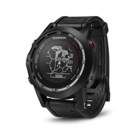
Garmin Fenix 2 - Performer Bundle

The new Garmin Fenix 2 Performance Bundle gives you everything you need to supply you with accurate and reliable navigation and training information when you are out and about doing whatever you do. This really is the ultimate combination of outdoor navigation and fitness training devices that is suitable for just about any activity you can think of. The heart of the Fenix 2 is Garmins superb high sensitivity GPS receiver with FastFix technology that finds satellites quickly and then hangs onto their signal even in dense woodland or steep sided valleys. In navigation mode this brilliant device can track where youve been; guide you on your pre-programmed route and then guide you back to safety by recording a track log, a GPS bread crumb trail as you travel. You can also record waypoints,
such as your start point, camp site, trig points and other POIs (points of interest). Using Garmin’s free BaseCamp desktop route planning software you can create your trip at home, download the data to Fenix 2 and follow the navigation arrow to waypoints or the clearly visible route line to your destination. If the clag comes down and visibility is reduced, or you just want to re-trace your steps you can use the TracBack facility to follow your automatically created tracklog trail back to safety. Other features to aid with navigation include a highly sensitive barometric altimeter and compass which are automatically calibrated using the GPS receiver to keep the data bang up to date and highly accurate. The built-in barometric altimeter provides elevation data to accurately monitor
ascent and descent, and the barometer can be used to predict weather changes by showing short-term trends in air pressure so you can keep an eye on changing weather patterns and make the necessary changes to your plans. The 3-axis electronic compass does not require you to be moving to indicate an accurate bearing and if you require precise ambient temperature readings you can pair up the Fenix with an optional wireless Tempe temperature sensor. In running mode the Fenix 2 provides all the information any casual or serious runner requires to stay on top of their fitness or to improve performance. Pace, time, distance, interval training options, autolap and many more features are available to address the specific needs of trail runners, and the Fenix 2 also provides a dedicated
profile showing shows data such as ascent, performance and vertical speed. You can even fully customise all of the available profiles to exactly match your specific training requirements. The Fenix 2 is an ideal training partner for all multi-sport activities such as Triathlon. During open water and indoor swimming the Fenix 2 tracks stroke count, intervals, distance, pace and more. During cycling the Fenix 2 provides detailed information by tracking cadence and power from optional sensors to complete your performance metrics. With the included heart rate monitor belt you can turn the Fenix 2 into a highly technical and sophisticated training data centre that can supply data and stats about your form and fitness. Perhaps the most important indication of your training progress is your
VO2 Max measurement; this gives you an estimation of your actual fitness based on your performance and various values of your heart rate. Fenix 2 records your VO2 max so that you can see real fitness gains to inspire and motivate you to keep up your training. The Fenix 2 is even able to make a prediction on your race time based on your VO2 Max value. After your training the recovery advisor tells you how much time you need to recover from your last activity. The HRM belt and Fenix combination incorporates sophisticated sensor feedback on your running form to provide multiple advanced running metrics. Running dynamic data on your cadence, vertical oscillation and ground contact time are recorded to analyse your running
RIP - This product is no longer available on our network. It was last seen on 31.03.2015

This page now acts as a permanent archive for this product. Add more information using the comments box below to ensure it can still be found by future generations.

Use our search facility to see if it is available from an alternative contributor.
  • Availability: Out Of Stock
  • Supplier: Trekitt
  • SKU: 7181
Availability: In Stock
£350.99

Product Description

The new Garmin Fenix 2 Performance Bundle gives you everything you need to supply you with accurate & reliable navigation & training information when you are out & about doing whatever you do. This really is the ultimate combination of outdoor navigation & fitness training devices that is suitable for just about any activity you can think of. The heart of the Fenix 2 is Garmins superb high sensitivity GPS receiver with Fast Fix technology that finds satellites quickly & then hangs onto their signal even in dense woodland or steep sided valleys. In navigation mode this brilliant device can track where youve been; guide you on your pre-programmed route & then guide you back to safety by recording a track log, a GPS bread crumb trail as you travel. You can also record waypoints, such as your start point, camp site, trig points & other POIs (points of interest). Using Garmin’s free Base Camp desktop route planning software you can create your trip at home, download the data to Fenix 2 & follow the navigation arrow to waypoints or the clearly visible route line to your destination. If the clag comes down & visibility is reduced, or you just want to re-trace your steps you can use the Trac Back facility to follow your automatically created tracklog trail back to safety. Other features to aid with navigation include a highly sensitive barometric altimeter & compass which are automatically calibrated using the GPS receiver to keep the data bang up to date & highly accurate. The built-in barometric altimeter provides elevation data to accurately monitor ascent & descent, & the barometer can be used to predict weather changes by showing short-term trends in air pressure so you can keep an eye on changing weather patterns & make the necessary changes to your plans. The 3-axis electronic compass does not require you to be moving to indicate an accurate bearing & if you require precise ambient temperature readings you can pair up the Fenix with an optional wireless Tempe temperature sensor. In running mode the Fenix 2 provides all the information any casual or serious runner requires to stay on top of their fitness or to improve performance. Pace, time, distance, interval training options, autolap & many more features are available to address the specific needs of trail runners, & the Fenix 2 also provides a dedicated profile showing shows data such as ascent, performance & vertical speed. You can even fully customise all of the available profiles to exactly match your specific training requirements. The Fenix 2 is an ideal training partner for all multi-sport activities such as Triathlon. During open water & indoor swimming the Fenix 2 tracks stroke count, intervals, distance, pace & more. During cycling the Fenix 2 provides detailed information by tracking cadence & power from optional sensors to complete your performance metrics. With the included heart rate monitor belt you can turn the Fenix 2 into a highly technical & sophisticated training data centre that can supply data & stats about your form & fitness. Perhaps the most important indication of your training progress is your VO2 Max measurement; this gives you an estimation of your actual fitness based on your performance & various values of your heart rate. Fenix 2 records your VO2 max so that you can see real fitness gains to inspire & motivate you to keep up your training. The Fenix 2 is even able to make a prediction on your race time based on your VO2 Max value. After your training the recovery advisor tells you how much time you need to recover from your last activity. The HRM belt & Fenix combination incorporates sophisticated sensor feedback on your running form to provide multiple advanced running metrics. Running dynamic data on your cadence, vertical oscillation & ground contact time are recorded to analyse your running

Reviews/Comments

Add New

Intelligent Comparison

Oooops!
We couldn't find anything!
Perhaps this product's unique.... Or perhaps we are still looking for comparisons!
Click to bump this page and we'll hurry up.

Price History

Oooops!
We couldn't find any historical pricing!

Vouchers

No voucher codes found.
Do you know a voucher code for this product or supplier? Add it to Insights for others to use.

Facebook

Jargon Buster

GPS - Global Positioning System - Global position using satellites
Eye - An organ which detects light
Date - A day on a calendar
Date - A social activity whith a current or potential partner
water - A chemical substance. Chemical formula H2O.
speed - A measurement of how fast an object travels between two points
running - A sport or hobbie of moving rapidly on foot. Can also refer to the running of equipment or run time refering to the length of time an applicance can run or the quiet running of an applicance.
Weather - is the change of an atmospheres conditions.
Safety - prevents damage being caused.
Heart - An organ that pumps blood around the body. Usually related to love.
Precise - A measurement on the accuracy of something
Accurate - A measurement of precision when all elements are correct.
Home - A place of permanent residence for families.
Reliable - Something that is consistently good and can be trusted.
technical - Something that relates to a good level of skill and methods.
Sophisticated - Something that is a high level of complexity, can relate to a persons personality.
Wireless - A wire free device that uses radio and microwaves to send signals.
Performance - When someone is presenting a form of entertainment, also how well someone is doing within a role.
Ideal - Something that satisfies a perfect criteria.
Combination - The process of two of more things being mixed or combined together.

Supplier Information

Trekitt
Page Updated: 2015-04-29 04:02:53

Community Generated Product Tags

Oh No! The productWIKI community hasn't generated any tags for this product yet!
Menu