
 United Kingdom
 France
 Germany
 Netherlands
 Sweden
 USA
USA
 Italy
Italy
 Spain
Spain
More From Contributor


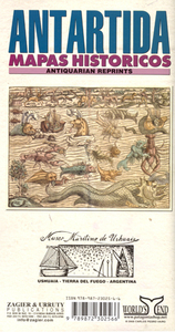
Antarctica: Historical Maps
An interesting collection of historical maps is arranged on this sheet - each representing the concept (realistic or otherwise) of the enigmatic continent of Antarctic - aka Terra Australis or Terra Incognita - at various times since the sixteenth century. The nine maps range in time from Cornelius Wyfliet’s 1598 map of Antarctica and South America and the Munster/Petri world map of the same year (informed partly by Magellan’s travels), to an 1845 map by Sduk showing several of the island groups in the south polar seas. Explanatory text in Spanish and English describes these maps and their significant aspects in the context of exploratory voyages which ventured further south and revealed more about the region and its geographic relationship with the neighbouring land masses.

Product Description
Reviews/Comments
Add New
Intelligent Comparison
Archived Product
Tasiilak Historical Map Stanfords
£15.95
Vouchers
No voucher codes found.
Do you know a voucher code for this product or supplier? Add it to Insights for others to use.
Do you know a voucher code for this product or supplier? Add it to Insights for others to use.
 Denmark