
 United Kingdom
 France
 Germany
 Netherlands
 Sweden
 USA
USA
 Italy
Italy
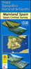
 Spain
Spain
More From Contributor


Antarctica: Maps International Wall Maps
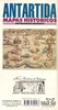
Large political map of Antarctica at a scale of 1:7, 000, 000 using data supplied by the British Antarctic Survey.*Presentation:* on paper; encapsulated; with hanging strips.*Sizes:* 100x120cm - Encapsulated maps, and versions with hanging strips may be slightly larger than this though.Countries are shown in vivid colours against light blue oceans. Country names are in large, clearly legible print. English versions of city names are used, with population information displayed on the legend; national territorial claims are displayed. Major railways are indicated, with major and minor roads also shown; ice stations, weather stations, base camps, aerodromes are clearly indicated, as are the winter and summer extents of the ice.The maps have well designed relief shading to show
mountainous areas enhancing the overall presentation. The colouring of the oceans shows different depths. Projection is Stereographic South Pole.The maps also contain insets detailing facts, figures and information about Antarctica.
mountainous areas enhancing the overall presentation. The colouring of the oceans shows different depths. Projection is Stereographic South Pole.The maps also contain insets detailing facts, figures and information about Antarctica.
Product Description
Reviews/Comments
Add New
Vouchers
No voucher codes found.
Do you know a voucher code for this product or supplier? Add it to Insights for others to use.
Do you know a voucher code for this product or supplier? Add it to Insights for others to use.
 Denmark