
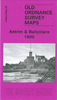
 United Kingdom
 France
 Germany
 Netherlands
 Sweden
 USA
USA
 Italy
Italy
 Spain
Spain
More From Contributor


Antuco - Laguna Del Laja National Park
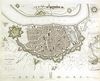
Antuco - Laguna del Laja National Park – Volcán Antuco – Sierra Velluda area at 1:30, 000 in a series of contoured, GPS compatible trekking and exploration maps at various scales form Trekkingchile. The map has contours at 50m intervals, with graphics/colouring to show glaciers and different types of vegetation. Road network indicates paved or gravel roads and dirt tracks. The map shows trekking routes with distances and symbols highlight various places of tourist interest: campsites, cabins and other types of accommodation, restaurants, animal observation points, fishing tours and boat trips, etc. Coverage extends from Abanico to the lake and north/south from the Lagunas Las Cóndores pass to the peak of Cordón Petronquines. The map has a UTM grid and latitude longitude
margin ticks at 1’. Map legend includes English.On the reverse are colour drawings of local fauna plus several English language advertisements for various services.Maps in the Trekkingchile series use satellite imagery as a base, with contour lines and colouring to indicate different types of terrain and habitats. Unless indicated to the contrary in the individual descriptions, the maps have a UTM grid, plus margin ticks for latitude and longitude. The maps are annotated with tourist information and most titles include a street plan of the region’s main town. Many are illustrated with drawings of local fauna or flora. Map legends and other text include English.To see the other titles in this series please click on the series link.
margin ticks at 1’. Map legend includes English.On the reverse are colour drawings of local fauna plus several English language advertisements for various services.Maps in the Trekkingchile series use satellite imagery as a base, with contour lines and colouring to indicate different types of terrain and habitats. Unless indicated to the contrary in the individual descriptions, the maps have a UTM grid, plus margin ticks for latitude and longitude. The maps are annotated with tourist information and most titles include a street plan of the region’s main town. Many are illustrated with drawings of local fauna or flora. Map legends and other text include English.To see the other titles in this series please click on the series link.
Product Description
Reviews/Comments
Add New
Vouchers
No voucher codes found.
Do you know a voucher code for this product or supplier? Add it to Insights for others to use.
Do you know a voucher code for this product or supplier? Add it to Insights for others to use.
 Denmark