More From Contributor

£9.99
Antonio Carluccio`s Simple Cooking is a coming together of all the `secrets` that Antonio has learned over his many years of cooking. Packed with easy, reliable & delicious dishes, it is the perfect cookbook for the novice & enthusiast alike. All the mouthwatering recipes featured are very easy to cook, perfect for those with little experience or who are short of time. Throughout, Antonio has also included clever suggestions for how to `upgrade` the basic recipe by adding a `luxury` ingredient or an extra component
- an anchovy or two, perhaps, some chilli & capers, or an accompanying sauce. There are also ingenious recipes for using up leftovers, with Antonio always remaining budget-conscious. &, of course, all the dishes are completely delicious, for they are Antonio`s favourites, employing the basic tenets of the finest Italian cooking: finest top quality ingredients prepared simply & served without fuss. The recipes are illustrated with fabulous photography by Alistair Hendy, including several step-by-step sequences. Antonio Carluccio`s Simple Cooking is a distillation of a lifetime of passion, full of Antonio`s firm belief that cooking, whether for oneself or for family & friends, is one of the most loving of human skills.
...
Archived Product
£3.50
Antrim & Ballyclare in 1900 in the Alan Godfrey Edition of historical Ordnance Survey mapping at one inch to one mile. The map covers a broad area of Co. Antrim stretching from Randalstown & Lough Neagh eastward to Whitehouse, & from Legoniel northward to Ballynure. Features include the long lost railway lines to Randalstown, Ballyclare & Doagh, the north Belfast suburbs of Legoniel & Whitehouse with Belfast Castle & Cave Hill, the Aldergrove area, part of Lough Neagh, Shanes Castle, Upton Castle, Muckamore Abbey, etc. Other locations covered by this map include Aldergrove, Ballyeaston, Ballynure, Carnomney, Doagh, Jordanstown, Killead, Legoniel, Mossley, Oldpark, Randalstown, Templepatrick, Whitehouse Lower & Whitehouse Upper. On the reverse is a detailed map of the village of Doagh, including the station, Fisherwick, Doagh Mill, Ballyhamage House & Hunterstown Bridge. About Alan Godfrey Editions of OS 1” to 1 mile maps of Ireland: The maps provide an invaluable overview of a wider area, typically 18 x 12 miles (29 x 19kms approx.), & offer historical mapping for small villages not covered by the more detailed series for which the Godfrey Editions are better known. All the maps include historical notes & all, unless indicated in the individual description, also include a large scale map of a small town or village in the area. ...
Archived Product
£10.99
My stories, my family`s stories, were not stories in India. They were just life. When I left & made new friends in a new country, only then did the things that happened to my family, the things we had done, become stories. Stories worth telling, stories worth writing down. Like one in six people in India, Sujatha Gidla was born an untouchable. Her mother & uncles were born in the last days of British colonial rule. They grew up in a world marked by poverty & injustice, but also full of possibility. In the slums where they lived, everyone had a political allegiance. Rallies, agitations & arrests were commonplace. The independence movement promised freedom but for untouchables & other poor & working people, little changed. In rich, novelistic prose, Ants Among Elephants tells Gidla`s remarkable family story, detailing her uncle`s emergence as a poet & revolutionary & her mother`s struggle for emancipation through education.A moving portrait of love, hardship & struggle, Ants Among Elephants is a personal history of modern India, told from the bottom up.` The story Gidla recounts is so urgent & affecting that it is easy to overlook the extraordinary literary skill with which she tells it.` Literary Review` Unsentimental, deeply poignant... Gidla writes with quiet, fierce conviction.` Michiko Kakutani, New York Times Book Review ...
Archived Product
£9.50
Antuco
- Laguna del Laja National Park – Volcán Antuco – Sierra Velluda area at 1:30, 000 in a series of contoured, GPS compatible
...
Archived Product
£7.99
`A fascinating, even compulsory addition to the Bolano fan`s bookshelf.. .the sentences whizz over your head like bullets` Daily Telegraph Antwerp was Roberto Bolano`s first novel, though he chose not to publish it until 2002, more than twenty years after he`d written it. Set amidst the seedy hotels & deserted campsites on the Costa Brava, & filled with hapless girls, failed poets, & shifty policemen, Antwerp is a short & cinematic experimental crime novel spliced together with voices from a dream, from a nightmare, from passers-by, from an omniscient narrator, from ` Roberto Bolano`. Intense & irrepressible, the novel is a personal declaration of the power of literature; reading it is to be present at the birth of Bolano`s enterprise in prose, to see the beginning, to witness the moment when his talent explodes. ` It`s hard to think of a writer who has multiplied the possibilities more times than Roberto Bolano` Nicole Krauss, Guardian ...
Archived Product
£11.50
Antwerp
- Turnhout
- Breda area in a series of cycling maps from Sportoena covering Belgium & the adjoining regions of the neighbouring

...
Archived Product
£160.00
Antwerp, an original antique map by S.D.U.K., published in London, 1844. Steel plate, coloured. Map size 29 x 30 cm, overall mounted size 54 x 46 cm.A detailed map of Antwerp published by the Society for the Diffusion of Useful Knowledge. The Society was founded by John, Earl Russell, & Henry Brougham, later Lord Chancellor of England in 1827. The Society's main purpose was to encourage universal literacy by publishing numbers of books of good quality that would be affordable to all. These town plans were published in perhaps the grandest of the Society's publications
- their atlas entitled Maps Of The Society For The Diffusion Of Useful Knowledge, first issued by Baldwin & Cradock, & then re-issued by other publishers, including Chapman & Hall & latterly Edward Stanford. The map

Includes::
a vignette view of Antwerp from the road to Mechlin, Brussels & Louvin. Along the bottom of the map the city's principal buildings are depicted. The map was engraved by B.R. Davies after W.B. Clarke. Antique maps from various original publishers are presented on the Stanford


...
Archived Product
£15.95
Antwerp & its conurbation on 155 pages of detailed street mapping, covering 49 communes in a paperback pocket atlas from De Rouck Geocart. The atlas provides continuous mapping for the whole area at 1:15, 000, with central Antwerp also shown at 1:12, 500. Streets which are part of the national road network are annotated with their road numbers & motorway junctions are shown with names. One way streets & tram lines are marked. Within the Antwerp port area dock names & quay numbers are shown together with names of main companies & businesses trading there.A wide range of symbols highlight various institutions, facilities & services. The maps have no geographical coordinates (i.e. no UTM or latitude & longitude, but they do show 500m lines of the Lambert projection of Belgium ...
Archived Product
£15.95
Antwerp & its conurbation in spiral-bound pocket atlas from De Rouck Geocart, in an A5 format but with each page of mapping unfolding to a larger, 18 x 18.5cm size. The whole are is covered at 1:17, 500, with the city centre shown at 1:10, 000. Streets which are part of the national road network are annotated with their road numbers & motorway junctions are shown with names. One way streets & tram lines are marked. Within the Antwerp port area dock names & quay numbers are shown together with names of main companies & businesses trading there.A wide range of symbols highlight various institutions, facilities & services. The maps have no geographical coordinates. Extensive index gives postcodes & start/end point for all streets &

Includes::
lists of various institutions & services, with a separate section for the docks area providing a list of docks, locks, tunnels, bridges, etc, plus addresses of customs offices, police, fire brigade, etc. Map legend

Includes::
English. Explanatory text for the index is in French & Dutch only.


...
Archived Product
£15.99
Alta Via`s topographical cycling maps emphasize car-free cycling routes or the so-called Voies Vertes (Green Routes), a cycling network that runs through Belgium & Luxembourg. All LF & Ravel cycle routes are included, supplemented with old railways & towpaths that have been transformed into bike paths. The map also lists all youth hostels, bivouac areas, trekking huts, etc. The scale is 1:75, 000 Printed on Stone-paper. ...
Archived Product

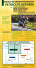
Antwerp - Bruges - Ghent F&B City Pocket Map

Central Antwerp, Bruges and Ghent in a series of handy pocket street plans from Freytag & Berndt. Town centre of each city is presented at 1:12, 500 on a separate 26x27cm panel accompanied by an index. On the reverse, publisher’s recommendations are also listed separately for each city. Unlike other titles in this series, this title does not panels with a road map or the Fact File. Each map in Freytag & Berndt’s City Pocket series is laminated, so waterproof and tear-resistant, and highlights the publishers’ recommendations of five best choices in five categories: shopping, restaurants and cafes, culture, nightlife and sights. On one side is an indexed street plan annotated with colour-coded markers highlighting the publishers’ recommendations, all listed on the reverse of
the map with brief notes in several languages. In larger cities the plans cover only the central districts. Also provided are a small road map of the city’s environs, if appropriate a diagram of the metro network, and a Fact Box with phone numbers for tourist offices, car hire and emergency services. Map legend and notes on the recommendations include English.To see other titles is this series please click on the series link.
RIP - This product is no longer available on our network. It was last seen on 25.09.2019

This page now acts as a permanent archive for this product. Add more information using the comments box below to ensure it can still be found by future generations.

Use our search facility to see if it is available from an alternative contributor.
  • External links may include paid for promotion
  • Availability: Out Of Stock
  • Supplier: Stanfords
  • SKU: 9783707914238
Availability: In Stock
£4.99

Product Description

Central Antwerp, Bruges & Ghent in a series of handy pocket street plans from Freytag & Berndt. Town centre of each city is presented at 1:12, 500 on a separate 26x 27cm panel accompanied by an index. On the reverse, publisher’s recommendations are also listed separately for each city. Unlike other titles in this series, this title does not panels with a road map or the Fact File. Each map in Freytag & Berndt’s City Pocket series is laminated, so waterproof & tear-resistant, & highlights the publishers’ recommendations of five best choices in five categories: shopping, restaurants & cafes, culture, nightlife & sights. On one side is an indexed street plan annotated with colour-coded markers highlighting the publishers’ recommendations, all listed on the reverse of the map with brief notes in several languages. In larger cities the plans cover only the central districts. Also provided are a small road map of the city’s environs, if appropriate a diagram of the metro network, & a Fact Box with phone numbers for tourist offices, car hire & emergency services. Map legend & notes on the recommendations include English. To see other titles is this series please click on the series link.

Reviews/Comments

Add New

Intelligent Comparison

Oooops!
We couldn't find anything!
Perhaps this product's unique.... Or perhaps we are still looking for comparisons!
Click to bump this page and we'll hurry up.

Price History

Vouchers

No voucher codes found.
Do you know a voucher code for this product or supplier? Add it to Insights for others to use.

Facebook

Jargon Buster

phone - Short for telephone. A device that transmits sound allowing point to point communication over long distances
Waterproof - Resistant to water, usualy specified by depth in metres
Car - A machine used for transport which runs on roads
Colour - The categorised spectrum of light visable to humans
Network - A link and communication between things. Often computers or people.
Small - something that takes up less space than normal.
Road - a manmade lane or a path that is used to speed up travel.
Resistant - Something that can repel against something.
Pocket - A bag shaped insert in clothing used to carry items
Laminated - A thin layer of plastic that gives a coating and shine to a material.

Supplier Information

Stanfords
Stanfords was established in 1853 and opened their iconic Covent Garden flagship store in 1901. They have become the top retailer of maps, travel books and accessories in the UK and arguably offer the largest selection of maps and travel books worldwide. Famous names such as Captain Robert Falcon Scott, Ranulph Fiennes and Michael Palin have purchased from Stanfords. They now have a shop in Bristol and both stores together with other venues operate a calendar of events including talks, book signings and exhibitions. As a specialist map retailer, the map selection is comprehensive and includes road maps, street maps and walking maps from worldwide destinations, as well as a selection of world atlases and wall maps. Books include travel guides and travel literature. Stanfords also stock globes, from miniatures made of blue marble to magnificent floor-standing globes. The website features a selection of interesting articles on travel topics.
Page Updated: 2023-11-12 20:15:36

Community Generated Product Tags

Oh No! The productWIKI community hasn't generated any tags for this product yet!
Menu